
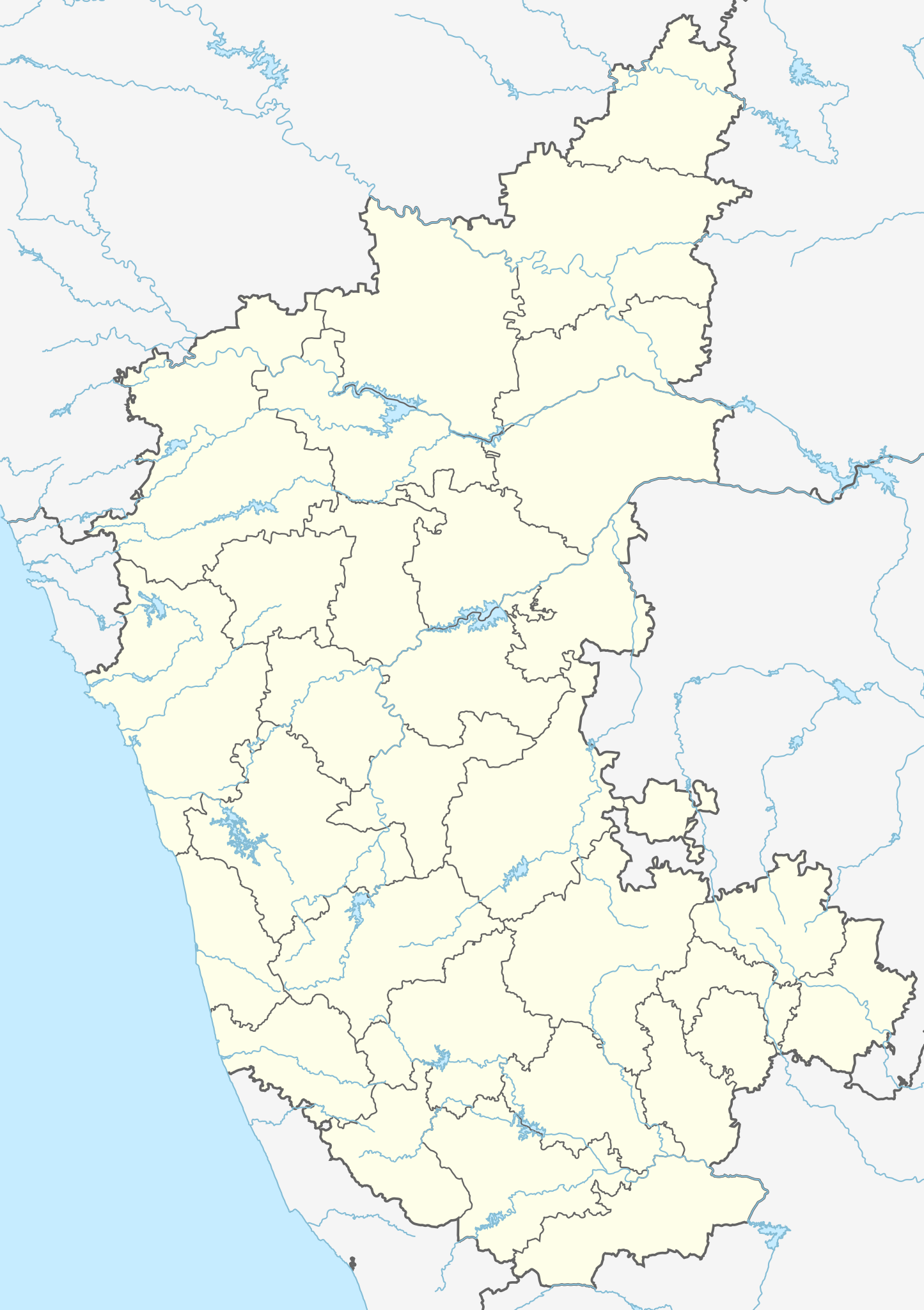
चित्र:India Karnataka location map.svg

Size of this PNG preview of this SVG file: ४२३ × ६०० पिक्सेल. इतर resolutions: १६९ × २४० पिक्सेल | ३३८ × ४८० पिक्सेल | ५४२ × ७६८ पिक्सेल | ७२२ × १,०२४ पिक्सेल | १,४४५ × २,०४८ पिक्सेल | ८९८ × १,२७३ पिक्सेल.
मूळ संचिका (SVG संचिका, साधारणपणे ८९८ × १,२७३ pixels, संचिकेचा आकार: ७५९ कि.बा.)
| वर्णन |
Location map of Karnataka Geographic limits of the map:
|
| दिनांक | (UTC) |
| स्रोत | |
| लेखक |
|
| इतर आवृत्तींस |
Derivative works of this file: |
| This is a retouched picture, which means that it has been digitally altered from its original version. Modifications: Created 3 new districts Chikkaballapur, Ramanagara and Yadgir. Changed conventions per WP:WPMAP. The original can be viewed here: Karnataka locator map.svg:
|
ही संचिका खालील परवान्याअंतर्गत आहे - क्रीएटिव्ह कॉमन्स Attribution-Share Alike 3.0 Unported.
- तुम्ही मुक्त आहात.
- सामायिक करा – नक्कल, वितरण आणि पारेषित करण्यास
- पुर्नमिश्रीत करण्यास – काम गरजेनुसार अनुकुलीत करण्यास
- खालील अटींच्या अधिन राहून:
- रोपण – आपण योग्य क्रेडिट देणे आवश्यक आहे, परवान्यास दुवा प्रदान करणे आवश्यक आहे, आणि बदल केले गेले आहेत हे दर्शविणे आवश्यक आहे. आपण हे कोणत्याही वाजवी मार्गाने करू शकता, परंतु परवानाधारक आपल्यास किंवा आपल्या वापरास मान्यता देतो अशा कोणत्याही मार्गाने नाही.
- जसेहोते-वाटातसेच (शेअर अलाईक) – जर तुम्ही या कामात काही बदल केलात, काटछाट केलीत, किंवा भर घातली, तर असे करून बनलेले नवीन काम तुम्ही केवळ या किंवा यासारख्याच परवान्याअंतर्गत प्रसारित करू शकतात.
चढवल्याचे मुळ विवरण
This image is a derivative work of the following images:
- File:Karnataka_locator_map.svg licensed with Cc-by-sa-3.0
- 2007-05-06T13:55:02Z Planemad 1630x2356 (231773 Bytes) {{WikiProject_India_Maps |Title=Karnataka locator Map |Description=Map of [[w:Karnataka]] with road and rail lines |Source= [http://aquarium.lipetsk.ru/discovery/India2004/karnataka-map.jpg Karnataka Map], [http://www.indianr
Uploaded with derivativeFX
संचिकेचा इतिहास
संचिकेची त्यावेळची आवृत्ती बघण्यासाठी त्या दिनांक/वेळेवर टिचकी द्या.
| दिनांक/वेळ | छोटे चित्र | आकार | सदस्य | प्रतिक्रीया | |
|---|---|---|---|---|---|
| सद्य | ०८:४०, १६ जून २०२३ | | ८९८ × १,२७३ (७५९ कि.बा.) | C1MM | c Vijayanagara district |
| १०:११, १३ ऑगस्ट २०२१ |  | ८५१ × १,२११ (५८२ कि.बा.) | C1MM | Added more rivers | |
| ०९:०३, १६ जुलै २०२१ |  | ८५१ × १,२११ (५६१ कि.बा.) | C1MM | Added more accurate district boundaries | |
| ०५:११, १५ डिसेंबर २०२० |  | १,६३४ × २,३६७ (३४१ कि.बा.) | C1MM | Fixed boundaries of Vijayanagara district | |
| ०३:४०, १५ डिसेंबर २०२० |  | १,६३४ × २,३६७ (३४५ कि.बा.) | C1MM | Added boundaries of AP/Telangana and rivers | |
| ००:५६, १४ डिसेंबर २०२० |  | १,६३४ × २,३६७ (३४२ कि.बा.) | C1MM | Fixed district boundaries of Ballari and added Vijayanagara district | |
| ०९:२३, २१ एप्रिल २०२० |  | १,६३४ × २,३६७ (२८९ कि.बा.) | C1MM | Added rivers | |
| २१:२०, १५ नोव्हेंबर २०१० |  | १,६३० × २,३५६ (२०७ कि.बा.) | Nayvik | Changed background color | |
| २१:०४, १५ नोव्हेंबर २०१० |  | १,६३० × २,३५६ (२०६ कि.बा.) | Nayvik | {{Information |Description=Location map of Karnataka Geographic limits of the map: * 18.5°N * 11.0°N * 73.6°E * 78.7°E |Source=*File:Karnataka_locator_map.svg, [http://www.censusindia.gov.in/2011-Images/ADMINI2011.jpg Census In |
दुवे
खालील पाने या संचिकेला जोडली आहेत:
- एच.ए.एल. विमानतळ
- कुंदापूर
- केंपेगौडा आंतरराष्ट्रीय विमानतळ
- गदग जंक्शन रेल्वे स्थानक
- गुलबर्गा रेल्वे स्थानक
- चिकबल्लपूर
- चित्रदुर्ग
- जोग धबधबा
- तोरणागल्लू
- निपाणी
- बंगळूर सिटी रेल्वे स्थानक
- बंटवाल रेल्वे स्थानक
- बदामी गुंफा मंदिरे
- बेळगांव रेल्वे स्थानक
- बेळ्ळारी
- मुरुदेश्वर
- मैसुरु जंक्शन रेल्वे स्थानक
- यशवंतपूर जंक्शन रेल्वे स्थानक
- यादगीर
- यादगीर रेल्वे स्थानक
- रायचूर रेल्वे स्थानक
- वाडी जंक्शन रेल्वे स्थानक
- शहाबाद
- शहाबाद रेल्वे स्थानक
- सुरतकल
- सैदापूर रेल्वे स्थानक
- हंपी
- हुबळी जंक्शन रेल्वे स्थानक
- होनावर
- होस्पेट
- साचा:Location map कर्नाटक
जागतिक संचिका उपयोग
संचिकाचे इतर विकिपीडियावरील वापरः
- ar.wikipedia.org वरील उपयोग
- as.wikipedia.org वरील उपयोग
- azb.wikipedia.org वरील उपयोग
- تومکور
- بنقلور
- عباسی، کارناتاکا
- اودقولام
- پیکلیهال
- اوداجی (هیندوستان)
- اوچیلا, اودوپی دیستریکت
- اوچاواد
- او خاناپور
- ویراهانوماکاناپالیا
- فاجیر (هیندوستان)
- پتالور (هیندوستان)
- پت آماپور
- ویراکامبا
- ویراپور
- وانور (هیندوستان)
- ساتیجری
- ساتانور, ماقادی
- ساتانور, بانقالور
- ساسالاتی
- سارقور
- ساراواد
- ساراپادی
- ساپتاساقار
- سانتور
- سانتکاسالاجر
- مایاکوندا
- ساناتی
- ماویناکر
- ماوالی
- ماتیواد
- کالادکا
- سانیکاتا
- کالکونت
- کالکری
- ماتماری
- سانقاناهالا
- کالجی (هیندوستان)
- سانقامشوارا, کالاقاتاجی
- ماتاداکوروباراهاتی
- ماستیهولی
- کالاسا, کوندقول
- ماسارکال
- ماسابینال
या संचिकेचे अधिक वैश्विक उपयोग पहा