
चित्र:Yangtze River Map.png
यापेक्षा मोठे चित्र उपलब्ध नाही.
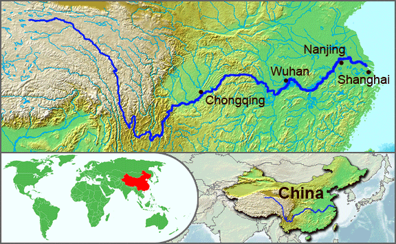
Yangtze_River_Map.png (५७६ × ३५५ पिक्सेल, संचिकेचा आकार: १२३ कि.बा., MIME प्रकार: image/png)
सारांश
| वर्णन |
English: The underlying topographic maps used in this image come from the Demis Web Map Server, and are in the public domain. The world locator map is derived from :Image:BlankMap-World.png. I added the feature layers myself. —Papayoung ☯ 20:57, 1 October 2005 (UTC) |
| दिनांक | ऑक्टोबर १, इ.स. २००५ (original upload date) |
| स्रोत | CommonsHelper द्वारे सदस्य Common Goodने en.wikipedia पासून कॉमन्सवर हस्तांतरित केले. |
| लेखक | The original uploader was Papayoung at इंग्रजी विकिपीडिया. |
| इतर आवृत्तींस |
|
.JPG)
परवाना:
| ही संचिका खालील परवान्याअंतर्गत आहे - क्रीएटिव्ह कॉमन्स Attribution-Share Alike 3.0 Unported. Subject to disclaimers. | ||
| ||
| GFDL चा भाग म्हणून परवाना अपडेट हि परवाना खूण या संचिकेस जोडलेली होती. (संचिका म्हणजे File) |

|
फ्री सॉफ्टवेअर फाऊंडेशन द्वारे प्रकाशित जीएनयू मुक्त दस्ताऐवजीकरण परवाना, आवृत्ती १.२ किंवा त्यानंतरची,या अंतर्गत; या दस्तावेजास, नकलविण्याची, वितरणाची व/किंवा फेरबदलाची परवानगी दिल्या जाते या अटींसह कि त्यात कोणतेही निश्चलित(Invariant) विभाग नकोत,पृष्टपान मजकूर नको व मलपान मजकूर नको. GNU Free Documentation License हा मथळा असलेल्या विभागात,या परवान्याची प्रत अंतर्भूत केलेली आहे. Subject to disclaimers. |
चढवल्याचे मुळ विवरण
The original description page was here. All following user names refer to en.wikipedia.
- 2005-10-01 20:51 Papayoung 576×355× (125604 bytes) The underlying topographic maps used in this image come from the [http://www2.demis.nl/mapserver/mapper.asp Demis Web Map Server], and are in the public domain. The world locator map is derived from [[Commons:Image:BlankMap-World.png|BlankMap-World.png]].
- 2005-09-25 22:57 Papayoung 936×363× (221574 bytes) The underlying topographic maps used in this image come from the [http://www2.demis.nl/mapserver/mapper.asp Demis Web Map Server], and are in the public domain. I added the feature layers myself. —~~~~
संचिकेचा इतिहास
संचिकेची त्यावेळची आवृत्ती बघण्यासाठी त्या दिनांक/वेळेवर टिचकी द्या.
| दिनांक/वेळ | छोटे चित्र | आकार | सदस्य | प्रतिक्रीया | |
|---|---|---|---|---|---|
| सद्य | ०२:००, ८ मे २००९ | | ५७६ × ३५५ (१२३ कि.बा.) | File Upload Bot (Magnus Manske) | {{BotMoveToCommons|en.wikipedia|year={{subst:CURRENTYEAR}}|month={{subst:CURRENTMONTHNAME}}|day={{subst:CURRENTDAY}}}} {{Information |Description={{en|The underlying topographic maps used in this image come from the [http://www2.demis.nl/mapserver/mapper |
दुवे
खालील पाने या संचिकेला जोडली आहेत:
जागतिक संचिका उपयोग
संचिकाचे इतर विकिपीडियावरील वापरः
- af.wikipedia.org वरील उपयोग
- als.wikipedia.org वरील उपयोग
- am.wikipedia.org वरील उपयोग
- ary.wikipedia.org वरील उपयोग
- ast.wikipedia.org वरील उपयोग
- as.wikipedia.org वरील उपयोग
- azb.wikipedia.org वरील उपयोग
- be-tarask.wikipedia.org वरील उपयोग
- bh.wikipedia.org वरील उपयोग
- bn.wikipedia.org वरील उपयोग
- bo.wikipedia.org वरील उपयोग
- br.wikipedia.org वरील उपयोग
- cs.wikipedia.org वरील उपयोग
- de.wikipedia.org वरील उपयोग
- en.wikipedia.org वरील उपयोग
- en.wikinews.org वरील उपयोग
- es.wikipedia.org वरील उपयोग
- et.wikipedia.org वरील उपयोग
- eu.wikipedia.org वरील उपयोग
- fi.wikipedia.org वरील उपयोग
- fo.wikipedia.org वरील उपयोग
- frr.wikipedia.org वरील उपयोग
- fr.wikipedia.org वरील उपयोग
- fr.wikivoyage.org वरील उपयोग
- fr.wiktionary.org वरील उपयोग
- fy.wikipedia.org वरील उपयोग
- hi.wikipedia.org वरील उपयोग
- hu.wikipedia.org वरील उपयोग
- hy.wikipedia.org वरील उपयोग
- hyw.wikipedia.org वरील उपयोग
- id.wikipedia.org वरील उपयोग
- ilo.wikipedia.org वरील उपयोग
- incubator.wikimedia.org वरील उपयोग
- io.wikipedia.org वरील उपयोग
- it.wikipedia.org वरील उपयोग
- ja.wikipedia.org वरील उपयोग
- ka.wikipedia.org वरील उपयोग
- ko.wikipedia.org वरील उपयोग
- ku.wikipedia.org वरील उपयोग
- la.wikipedia.org वरील उपयोग
- lfn.wikipedia.org वरील उपयोग
या संचिकेचे अधिक वैश्विक उपयोग पहा