
चित्र:Sunga-Border.jpg
या झलकेचा आकार: ५३६ × ५९९ पिक्सेल पिक्सेल. इतर resolutions: २१५ × २४० पिक्सेल | ४३० × ४८० पिक्सेल | ७९२ × ८८५ पिक्सेल.
मूळ संचिका (७९२ × ८८५ पिक्सेल, संचिकेचा आकार: ५४५ कि.बा., MIME प्रकार: image/jpeg)
सारांश
| वर्णन |
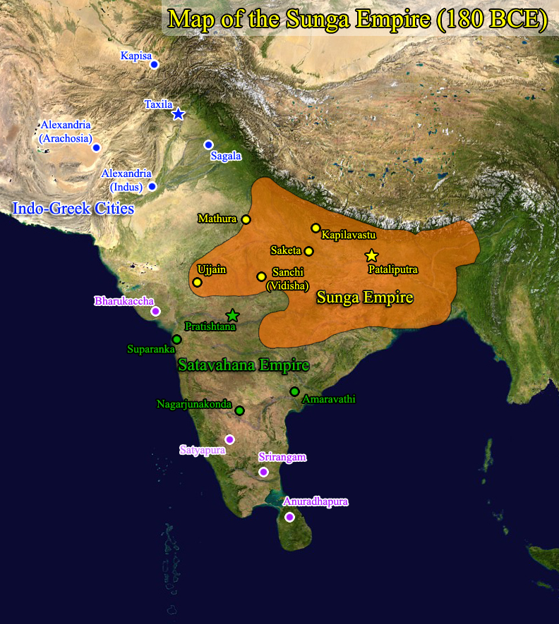
English: Map of the Sunga Empire based on Oxford University Atlas |
| दिनांक | 10/02/2009 |
| स्रोत | स्वतःचे काम (Original text: I (Windy City Dude (talk)) created this work entirely by myself.) |
| लेखक | Windy City Dude |
परवाना:
| This work has been released into the public domain by its author, Windy City Dude at इंग्रजी विकिपीडिया. This applies worldwide. असे करणे काही देशांमधे कायद्यानुसार शक्य नसू शकते. असे असल्यास : Windy City Dude grants anyone the right to use this work for any purpose, without any conditions, unless such conditions are required by law. |
चढवल्याचे मुळ विवरण
CommonsHelper द्वारे सदस्य Alagosने en.wikipedia पासून कॉमन्सवर हस्तांतरित केले.
The original description page was here. All following user names refer to en.wikipedia.
- 2009-10-20 03:36 Windy City Dude 792×885× (557619 bytes) {{Information |Description = Map of the Sunga Empire based on Oxford University Atlas |Source = I (~~~) created this work entirely by myself. |Date = 10/02/2009 |Author = Windy City Dude |other_versions = }}
संचिकेचा इतिहास
संचिकेची त्यावेळची आवृत्ती बघण्यासाठी त्या दिनांक/वेळेवर टिचकी द्या.
| दिनांक/वेळ | छोटे चित्र | आकार | सदस्य | प्रतिक्रीया | |
|---|---|---|---|---|---|
| सद्य | २३:४५, १९ नोव्हेंबर २०१३ | | ७९२ × ८८५ (५४५ कि.बा.) | File Upload Bot (Magnus Manske) | Transfered from en.wikipedia by User:Alagos using CommonsHelper |
दुवे
खालील पाने या संचिकेला जोडली आहेत:
जागतिक संचिका उपयोग
संचिकाचे इतर विकिपीडियावरील वापरः
- ar.wikipedia.org वरील उपयोग
- azb.wikipedia.org वरील उपयोग
- bn.wikipedia.org वरील उपयोग
- ca.wikipedia.org वरील उपयोग
- cv.wikipedia.org वरील उपयोग
- en.wikipedia.org वरील उपयोग
- es.wikipedia.org वरील उपयोग
- fa.wikipedia.org वरील उपयोग
- fr.wikipedia.org वरील उपयोग
- hi.wikipedia.org वरील उपयोग
- hu.wikipedia.org वरील उपयोग
- id.wikibooks.org वरील उपयोग
- pnb.wikipedia.org वरील उपयोग
- pt.wikipedia.org वरील उपयोग
- ro.wikipedia.org वरील उपयोग
- ru.wikipedia.org वरील उपयोग
- ta.wikipedia.org वरील उपयोग
- te.wikipedia.org वरील उपयोग
- tl.wikipedia.org वरील उपयोग
- uk.wikipedia.org वरील उपयोग
- ur.wikipedia.org वरील उपयोग
- www.wikidata.org वरील उपयोग