
चित्र:Roman Italy.gif

या झलकेचा आकार: ५१९ × ६०० पिक्सेल पिक्सेल. इतर resolutions: २०८ × २४० पिक्सेल | ४१५ × ४८० पिक्सेल | ८४६ × ९७८ पिक्सेल.
मूळ संचिका (८४६ × ९७८ पिक्सेल, संचिकेचा आकार: ७२ कि.बा., MIME प्रकार: image/gif)
सारांश

|
This locator map image could be re-created using vector graphics as an SVG file. This has several advantages; see Commons:Media for cleanup for more information. If an SVG form of this image is available, please upload it and afterwards replace this template with
{{vector version available|new image name}}.
It is recommended to name the SVG file “Roman Italy.svg”—then the template Vector version available (or Vva) does not need the new image name parameter. |

| वर्णन |
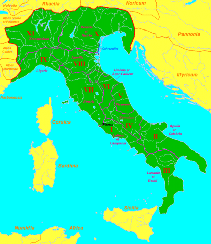
English: Map of Roman Italy (green) and surrounding provinces (orange), showing its division in 11 regiones, with their names.
Sources: partly based in maps of the University of Oregon [1], [2] and several maps and data of Wikipedia. |
| दिनांक | नोव्हेंबर १६, इ.स. २००७ (original upload date) |
| स्रोत | ने en.wikipedia पासून कॉमन्सवर हस्तांतरित केले. |
| लेखक | Sugaar at इंग्रजी विकिपीडिया |
![[1]](http://darkwing.uoregon.edu/~mapplace/EU/EU02-RepItaly/EU02-26.gif)
![[2]](http://darkwing.uoregon.edu/~mapplace/EU/EU02-RepItaly/EU02-25.jpeg)
परवाना:
| This work has been released into the public domain by its author, Sugaar at इंग्रजी विकिपीडिया. This applies worldwide. असे करणे काही देशांमधे कायद्यानुसार शक्य नसू शकते. असे असल्यास : Sugaar grants anyone the right to use this work for any purpose, without any conditions, unless such conditions are required by law. |
चढवल्याचे मुळ विवरण
The original description page was here. All following user names refer to en.wikipedia.
- 2007-11-16 07:29 Sugaar 846×978×8 (43924 bytes) Map of [[Italia (Roman Empire)|Roman Italy]] (green) and surrounding provinces (orange), showing its division in 11 ''regiones'', with their names.
संचिकेचा इतिहास
संचिकेची त्यावेळची आवृत्ती बघण्यासाठी त्या दिनांक/वेळेवर टिचकी द्या.
| दिनांक/वेळ | छोटे चित्र | आकार | सदस्य | प्रतिक्रीया | |
|---|---|---|---|---|---|
| सद्य | ०१:४०, २८ ऑगस्ट २०१३ | | ८४६ × ९७८ (७२ कि.बा.) | Enok | fixed border of Etruria |
| २२:१७, २० फेब्रुवारी २००८ |  | ८४६ × ९७८ (४३ कि.बा.) | Mach | {{Information |Description={{en|Map of Roman Italy (green) and surrounding provinces (orange), showing its division in 11 ''regiones'', with their names. Sources: partly based in maps of the University of Oregon [http://dark |
दुवे
खालील पाने या संचिकेला जोडली आहेत:
जागतिक संचिका उपयोग
संचिकाचे इतर विकिपीडियावरील वापरः
- ar.wikipedia.org वरील उपयोग
- be.wikipedia.org वरील उपयोग
- bg.wikipedia.org वरील उपयोग
- de.wikipedia.org वरील उपयोग
- el.wikipedia.org वरील उपयोग
- en.wikipedia.org वरील उपयोग
- es.wikipedia.org वरील उपयोग
- et.wikipedia.org वरील उपयोग
- fa.wikipedia.org वरील उपयोग
- gl.wikipedia.org वरील उपयोग
- hr.wikipedia.org वरील उपयोग
- hu.wikipedia.org वरील उपयोग
- hy.wikipedia.org वरील उपयोग
- id.wikipedia.org वरील उपयोग
- it.wikipedia.org वरील उपयोग
- ja.wikipedia.org वरील उपयोग
- ka.wikipedia.org वरील उपयोग
- ko.wikipedia.org वरील उपयोग
- lt.wikipedia.org वरील उपयोग
- ms.wikipedia.org वरील उपयोग
- nl.wikipedia.org वरील उपयोग
- no.wikipedia.org वरील उपयोग
- oc.wikipedia.org वरील उपयोग
- pl.wiktionary.org वरील उपयोग
- pt.wikipedia.org वरील उपयोग
- ro.wikipedia.org वरील उपयोग
- ru.wikipedia.org वरील उपयोग
- sh.wikipedia.org वरील उपयोग
- simple.wikipedia.org वरील उपयोग
- sl.wikipedia.org वरील उपयोग
या संचिकेचे अधिक वैश्विक उपयोग पहा