
चित्र:Puducherry Electoral Constituencies Map.svg

Size of this PNG preview of this SVG file: ८०० × ४३६ पिक्सेल. इतर resolutions: ३२० × १७४ पिक्सेल | ६४० × ३४९ पिक्सेल | १,०२४ × ५५८ पिक्सेल | १,२८० × ६९७ पिक्सेल | २,५६० × १,३९४ पिक्सेल | १,४९३ × ८१३ पिक्सेल.
मूळ संचिका (SVG संचिका, साधारणपणे १,४९३ × ८१३ pixels, संचिकेचा आकार: ५९० कि.बा.)
सारांश
| वर्णन |
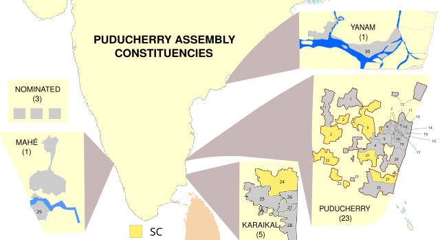
English: Map showing the electoral districts of the Union Territory of Puducherry, India. Uses File:Puducherry Map.svg (self made) as a base. Constituency maps for Puducherry and Karaikal recreated from File:Puducherry-Assembly-Constituencies-1-30-assembly-election-2011.png. |
| दिनांक | 01/03/2021 |
| स्रोत | स्वतःचे काम |
| लेखक | RaviC |
परवाना:
I, the copyright holder of this work, hereby publish it under the following license:
ही संचिका खालील परवान्याअंतर्गत आहे - क्रीएटिव्ह कॉमन्स Attribution-Share Alike 3.0 Unported.
- तुम्ही मुक्त आहात.
- सामायिक करा – नक्कल, वितरण आणि पारेषित करण्यास
- पुर्नमिश्रीत करण्यास – काम गरजेनुसार अनुकुलीत करण्यास
- खालील अटींच्या अधिन राहून:
- रोपण – आपण योग्य क्रेडिट देणे आवश्यक आहे, परवान्यास दुवा प्रदान करणे आवश्यक आहे, आणि बदल केले गेले आहेत हे दर्शविणे आवश्यक आहे. आपण हे कोणत्याही वाजवी मार्गाने करू शकता, परंतु परवानाधारक आपल्यास किंवा आपल्या वापरास मान्यता देतो अशा कोणत्याही मार्गाने नाही.
- जसेहोते-वाटातसेच (शेअर अलाईक) – जर तुम्ही या कामात काही बदल केलात, काटछाट केलीत, किंवा भर घातली, तर असे करून बनलेले नवीन काम तुम्ही केवळ या किंवा यासारख्याच परवान्याअंतर्गत प्रसारित करू शकतात.
संचिकेचा इतिहास
संचिकेची त्यावेळची आवृत्ती बघण्यासाठी त्या दिनांक/वेळेवर टिचकी द्या.
| दिनांक/वेळ | छोटे चित्र | आकार | सदस्य | प्रतिक्रीया | |
|---|---|---|---|---|---|
| सद्य | २१:१७, १५ मार्च २०२१ | | १,४९३ × ८१३ (५९० कि.बा.) | RaviC | Improved constituency boundaries for Puducherry district from File:Wahlkreise zur Vidhan Sabha von Puducherry.svg, added numbering |
| १७:४१, १ मार्च २०२१ |  | १,४९३ × ८१३ (५४१ कि.बा.) | RaviC | more fixes | |
| १७:३५, १ मार्च २०२१ |  | १,४९३ × ८१३ (५४३ कि.बा.) | RaviC | Yanam spelling // Editing SVG source code using c:User:Rillke/SVGedit.js | |
| १७:३१, १ मार्च २०२१ |  | १,४९३ × ८१३ (५४३ कि.बा.) | RaviC | improvements | |
| १७:२१, १ मार्च २०२१ |  | १,४९३ × ८१३ (५४३ कि.बा.) | RaviC | =={{int:filedesc}}== {{Information |description={{en|1=Map showing the electoral districts of the Union Territory of Puducherry, India. Uses File:Puducherry Map.svg (self made) as a base. Constituency maps for Puducherry and Karaikal recreated from Puducherry-Assembly-Constituencies-1-30-assembly-election-2011.png |date=01/03/2021 |source={{own}} |author=RaviC |permission= |other_versions= }} =={{int:license-header}}== {{self|cc-by-sa-3.0}} [[Category:SVG maps... |
दुवे
खालील पाने या संचिकेला जोडली आहेत:
जागतिक संचिका उपयोग
संचिकाचे इतर विकिपीडियावरील वापरः
- en.wikipedia.org वरील उपयोग
- pnb.wikipedia.org वरील उपयोग
- te.wikipedia.org वरील उपयोग
- ur.wikipedia.org वरील उपयोग