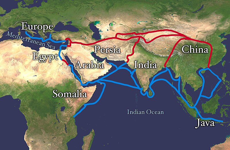
चित्र:Silk route.jpg

या झलकेचा आकार: ८०० × ५२१ पिक्सेल पिक्सेल. इतर resolutions: ३२० × २०८ पिक्सेल | ६४० × ४१६ पिक्सेल | १,०२४ × ६६६ पिक्सेल | १,२८० × ८३३ पिक्सेल | २,८६८ × १,८६६ पिक्सेल.
मूळ संचिका (२,८६८ × १,८६६ पिक्सेल, संचिकेचा आकार: ८१९ कि.बा., MIME प्रकार: image/jpeg)
संचिकेचा इतिहास
संचिकेची त्यावेळची आवृत्ती बघण्यासाठी त्या दिनांक/वेळेवर टिचकी द्या.
| दिनांक/वेळ | छोटे चित्र | आकार | सदस्य | प्रतिक्रीया | |
|---|---|---|---|---|---|
| सद्य | १६:०८, ४ जुलै २०१८ |  | २,८६८ × १,८६६ (८१९ कि.बा.) | Bongan | sea route modify because of Rama Setu ({{Adam's Bridge}}) |
| १९:३१, ८ फेब्रुवारी २०१८ |  | २,८६८ × १,८६६ (१.५७ मे.बा.) | Darwgon0801 | Reverted to version as of 17:45, 30 December 2012 (UTC) | |
| १३:१२, २२ नोव्हेंबर २०१७ |  | २,८६८ × १,८६६ (२.०६ मे.बा.) | Ibrahim Muizzuddin | Reverted to version as of 13:19, 12 April 2012 (UTC) Revert to more credible version | |
| २३:१५, ३० डिसेंबर २०१२ |  | २,८६८ × १,८६६ (१.५७ मे.बा.) | 23prootie~commonswiki | Adding Brunei and the Lucoes | |
| १८:४९, १२ एप्रिल २०१२ |  | २,८६८ × १,८६६ (२.०६ मे.बा.) | Splette | correct typo | |
| १५:४५, १२ एप्रिल २०१२ |  | २,८६८ × १,८६६ (२.०६ मे.बा.) | Splette | correct the position of the 'Somalia' label | |
| १०:२१, २७ मे २०१० |  | २,८६८ × १,८६६ (१.९३ मे.बा.) | Splette | one more try... better contrast | |
| १०:१५, २७ मे २०१० |  | २,८६८ × १,८६६ (१.९४ मे.बा.) | Splette | change colors | |
| १०:०७, २७ मे २०१० |  | २,८६८ × १,८६६ (१.९३ मे.बा.) | Splette | {{Information |Description=Extent of Silk Route/Silk Road. Red is land route and the blue is the sea/water route. |Source=*File:Whole_world_-_land_and_oceans_12000.jpg |Date=2010-05-27 04:33 (UTC) |Author=*[[:File:Whole_world_-_land_and_oceans_12000 |
दुवे
खालील पाने या संचिकेला जोडली आहेत:
जागतिक संचिका उपयोग
संचिकाचे इतर विकिपीडियावरील वापरः
- af.wikipedia.org वरील उपयोग
- anp.wikipedia.org वरील उपयोग
- ast.wikipedia.org वरील उपयोग
- azb.wikipedia.org वरील उपयोग
- az.wikipedia.org वरील उपयोग
- ba.wikipedia.org वरील उपयोग
- be-tarask.wikipedia.org वरील उपयोग
- bg.wikipedia.org वरील उपयोग
- bn.wikipedia.org वरील उपयोग
- bs.wikipedia.org वरील उपयोग
- ca.wikipedia.org वरील उपयोग
- ce.wikipedia.org वरील उपयोग
- chr.wikipedia.org वरील उपयोग
- crh.wikipedia.org वरील उपयोग
- da.wikipedia.org वरील उपयोग
- de.wikipedia.org वरील उपयोग
- el.wikipedia.org वरील उपयोग
- el.wikivoyage.org वरील उपयोग
- en.wikipedia.org वरील उपयोग
या संचिकेचे अधिक वैश्विक उपयोग पहा


