
चित्र:Maps template-en.svg

Size of this PNG preview of this SVG file: ३६५ × ५९८ पिक्सेल. इतर resolutions: १४६ × २४० पिक्सेल | २९३ × ४८० पिक्सेल | ४६८ × ७६८ पिक्सेल | ६२४ × १,०२४ पिक्सेल | १,२४९ × २,०४८ पिक्सेल | १,०९६ × १,७९७ पिक्सेल.
मूळ संचिका (SVG संचिका, साधारणपणे १,०९६ × १,७९७ pixels, संचिकेचा आकार: २९० कि.बा.)
| वर्णन |
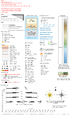
English: Template of Wikipedia map conventions. Français : Version anglais. Modèle pour la création de cartes géographiques et topographiques avec les principaux éléments habituellement employés et qui suit les conventions cartographiques actuelles de WP-fr et pour certains éléments en partie dans WP-de. (Pour le version Français, cliquez ici.) |
||||||||
| दिनांक | 29 November 2014 (English translation); 14 October 2012 (French original work) | ||||||||
| स्रोत |
|
||||||||
| लेखक | Eric Gaba (Sting - fr:Sting) | ||||||||
| परवानगी (या संचिकेचा पुनर्वापर करीत आहे) |
मी, या कामाचा/कामाची परवानाधारक, खालील परवान्यांअंतर्गत हे काम येथे प्रकाशित करत आहे : ही संचिका खालील परवान्याअंतर्गत आहे - क्रीएटिव्ह कॉमन्स Attribution 2.5 Generic.
तुमच्या पसंतीचा परवाना तुम्ही निवडू शकता. |
||||||||
| इतर आवृत्तींस |
English: Versions of the Maps template, a toolbox helping wiki-mapmakers and contains icons and formatted text/objects that serve as a template for Wikipedia map conventions. The French version is the 'mother one', the first to be updated, and is frequently improved and updated following calm talks between mapmakers. Experienced cartographers may propose (using English) a new icon on this talkpage.
|


W3C-validity not checked.
चढवल्याचे मुळ विवरण
This image is a derivative work of the following images:
- File:Maps_template-fr.svg licensed with Cc-by-2.5, Cc-by-2.5, GFDL, GFDL/en
- 2009-01-27T13:06:03Z Yug 1100x1500 (203738 Bytes) MINOR UPDATES: 2009/01/27. Add: port ; bat. judaisme, bat. chinese religions. Correct: terre principal fefee4 -> fefee9 (german usage) Add frames' titles, legend box. Move frames to more suitable place.
- 2008-09-04T00:08:14Z Sting 1100x1500 (176632 Bytes) Several little improvements
- 2008-07-15T14:45:27Z Sting 1100x1500 (170548 Bytes) Some improvements
- 2008-06-24T01:02:19Z Sting 1100x1500 (170673 Bytes) Valors for elevations and depths deleted to avoid confusion
- 2008-06-23T18:53:20Z Sémhur 1100x1500 (170836 Bytes) Change lighthouse icon, and decrease weight
- 2008-06-22T14:26:16Z Sting 1100x1500 (209351 Bytes) Additional topo colors for high elevations/permanent snow areas
- 2008-06-18T13:06:33Z Sting 1100x1500 (202960 Bytes) Additional modifications
- 2008-06-17T02:19:19Z Sting 1100x1500 (202606 Bytes) Some slight modifications
- 2008-06-13T14:51:52Z Sting 1100x1500 (202325 Bytes) Linear scales reduced to one type
- 2008-06-11T22:30:44Z Sting 1100x1500 (331785 Bytes) Some adjustments
- 2008-06-11T03:57:09Z Sting 1100x1500 (324893 Bytes) == Summary == {{Information |Description={{en|Template for the creation of geographic and topographic maps with the most common features used and following the convention to be used in the whole Wikimedia projet. *'''''Import
Uploaded with derivativeFX
संचिकेचा इतिहास
संचिकेची त्यावेळची आवृत्ती बघण्यासाठी त्या दिनांक/वेळेवर टिचकी द्या.
| दिनांक/वेळ | छोटे चित्र | आकार | सदस्य | प्रतिक्रीया | |
|---|---|---|---|---|---|
| सद्य | ११:०१, १३ जुलै २०२२ | | १,०९६ × १,७९७ (२९० कि.बा.) | Chess | fix minor typo |
| २०:३३, ४ डिसेंबर २०१४ |  | १,०९६ × १,७९७ (२९० कि.बा.) | Goran tek-en | This file is now edited so that Id-names and Label-names for objects pass thru the validator (gets green ribbon) for xml [http://validator.w3.org/ w3 validator]. No errors but warnings for no fall back font. The font is also changed to Liberation sans... | |
| ०८:२१, ३० नोव्हेंबर २०१४ |  | १,१०० × १,६०० (२५१ कि.बा.) | AHeneen | Translation of the French version dated 14 October 2012 | |
| १२:०१, १२ जून २०११ |  | १,१०० × १,५०० (१९७ कि.बा.) | Juergeen | typos | |
| १२:००, १२ जून २०११ |  | १,१०० × १,५०० (१९७ कि.बा.) | Juergeen | typos | |
| २३:२३, २७ जानेवारी २००९ |  | १,१०० × १,५०० (१९७ कि.बा.) | Bamse | {{Information |Description={{en|Template for the creation of geographic and topographic maps with the most common features used, following the current convention in WP-fr, and for some elements also in part of WP-de.}} {{fr|Modèle pour la création de ca |
दुवे
या चित्राशी जोडलेली पृष्ठे नाहीत.
जागतिक संचिका उपयोग
संचिकाचे इतर विकिपीडियावरील वापरः
- en.wikipedia.org वरील उपयोग
- Wikipedia:WikiProject Maps
- Wikipedia talk:Manual of Style/Diagrams and maps
- User:Yug
- Wikipedia:WikiProject Maps/Conventions
- Wikipedia:WikiProject Maps/Conventions/Exchanges maps
- Wikipedia:WikiProject Maps/Conventions/Area maps
- Wikipedia:WikiProject Maps/Conventions/Topographic maps
- Wikipedia:WikiProject Maps/Conventions/Location maps
- Wikipedia:WikiProject Maps/Conventions/Locator maps
- Template:Map conventions
- User:Yug/Map convention
- Wikipedia:WikiProject Maps/Conventions/Historical maps
- User:Wereldburger758
- User:DiverDave/Useful
- Wikipedia:WikiProject Maps/Conventions/Orthographic maps
- User:Jm34harvey/Mapping
- Wikipedia talk:WikiProject Maps/Archive 2009
- Wikipedia talk:WikiProject Maps/Archive 2010
- Wikipedia:Village pump (miscellaneous)/Archive 32
- User:Jkan997
- Wikipedia:Graphics Lab/Resources/GIS sources and palettes
- Wikipedia:Reference desk/Archives/Miscellaneous/2011 July 1
- Wikipedia:WikiProject Maps/Conventions/Disputed areas
- Wikipedia:WikiProject Maps/Conventions/Gradient maps
- Wikipedia:WikiProject Maps/Conventions/Pushpin maps
- Wikipedia:WikiProject Maps/Conventions/US locations
- User:Every-leaf-that-trembles
- Wikipedia talk:WikiProject Maps/Archive 2017
- User:Beevil/Useful
- Typography (cartography)
- Wikipedia:WikiProject Maps/Conventions/Location maps (series N)
- ja.wikipedia.org वरील उपयोग
- pl.wikipedia.org वरील उपयोग
- sl.wikipedia.org वरील उपयोग
- tg.wikipedia.org वरील उपयोग
- www.wikidata.org वरील उपयोग
- zh.wikipedia.org वरील उपयोग