
चित्र:Kingdom of Mann and the Isles-en.svg

Size of this PNG preview of this SVG file: ५७१ × ६०० पिक्सेल. इतर resolutions: २२९ × २४० पिक्सेल | ४५७ × ४८० पिक्सेल | ७३१ × ७६८ पिक्सेल | ९७५ × १,०२४ पिक्सेल | १,९५० × २,०४८ पिक्सेल | १,२९७ × १,३६२ पिक्सेल.
मूळ संचिका (SVG संचिका, साधारणपणे १,२९७ × १,३६२ pixels, संचिकेचा आकार: २०९ कि.बा.)
सारांश
| वर्णन |
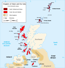
English: Map of the kingdom of Mann and the Isles, nearly the end of eleventh century.
Norðr: Shetland and Orkney
Sodor: Man and Hebrides Français : Carte du royaume de Man et des Îles, vers la fin du onzième siècle.
Norðr : Shetland et Orcades
Sodor : Man et Hebrides |
||
| दिनांक | |||
| स्रोत |
Own work based on: British Isles.svg, Mormaerdoms.png आणि Www.wesleyjohnston.com-users-ireland-maps-historical-map1014.gif |
||
| लेखक | Sémhur | ||
| इतर आवृत्तींस |
Derivative works of this file: Kingdom of Mann and the Isles-es.svg
|
||
| रोपण (required by the license) | © Sémhur / Wikimedia Commons / | ||
| SVG | W3C-validity not checked.
|
||
| Atelier graphique |

| Camera location | | View this and other nearby images on: OpenStreetMap |
|---|
परवाना:
मी, या कामाचा/कामाची परवानाधारक, खालील परवान्यांअंतर्गत हे काम येथे प्रकाशित करत आहे :
| प्रतसोड(कॉपीलेफ्ट):हि कलाकृती मुक्त आहे; तुम्ही ती पुर्नवितरीत करू शकता आणि/किंवा मुक्त कला परवान्यास अनुसरून Free Art License तीला बदलू शकता.या परवान्याचे स्पेसिमन तुम्हाला Copyleft Attitude संकेतस्थळ अथवा इतर संकेतस्थळांवर उपलब्ध होऊ शकते. |
ही संचिका खालील परवान्यांअंतर्गत आहे - क्रीएटिव्ह कॉमन्स Attribution-Share Alike 3.0 Unported, 2.5 Generic, 2.0 Generic आणि 1.0 Generic.
- तुम्ही मुक्त आहात.
- सामायिक करा – नक्कल, वितरण आणि पारेषित करण्यास
- पुर्नमिश्रीत करण्यास – काम गरजेनुसार अनुकुलीत करण्यास
- खालील अटींच्या अधिन राहून:
- रोपण – आपण योग्य क्रेडिट देणे आवश्यक आहे, परवान्यास दुवा प्रदान करणे आवश्यक आहे, आणि बदल केले गेले आहेत हे दर्शविणे आवश्यक आहे. आपण हे कोणत्याही वाजवी मार्गाने करू शकता, परंतु परवानाधारक आपल्यास किंवा आपल्या वापरास मान्यता देतो अशा कोणत्याही मार्गाने नाही.
- जसेहोते-वाटातसेच (शेअर अलाईक) – जर तुम्ही या कामात काही बदल केलात, काटछाट केलीत, किंवा भर घातली, तर असे करून बनलेले नवीन काम तुम्ही केवळ या किंवा यासारख्याच परवान्याअंतर्गत प्रसारित करू शकतात.
तुमच्या पसंतीचा परवाना तुम्ही निवडू शकता.
संचिकेचा इतिहास
संचिकेची त्यावेळची आवृत्ती बघण्यासाठी त्या दिनांक/वेळेवर टिचकी द्या.
| दिनांक/वेळ | छोटे चित्र | आकार | सदस्य | प्रतिक्रीया | |
|---|---|---|---|---|---|
| सद्य | ०१:३६, २७ डिसेंबर २०१५ | | १,२९७ × १,३६२ (२०९ कि.बा.) | Alphathon | Various minor corrections/tweaks |
| १५:३६, १५ ऑक्टोबर २००७ |  | १,२९७ × १,३६२ (२०८ कि.बा.) | Sémhur | {{Information |Description=Map of the kingdom of Mann and the Isles, nearly the end of eleventh century |Source=Own work, from : * Map of British Isles * [[:Image:Mormaerdoms.png|Map of kingdoms of Scotland in the Middle Ages] |
दुवे
या चित्राशी जोडलेली पृष्ठे नाहीत.
जागतिक संचिका उपयोग
संचिकाचे इतर विकिपीडियावरील वापरः
- af.wikipedia.org वरील उपयोग
- be.wikipedia.org वरील उपयोग
- bn.wikipedia.org वरील उपयोग
- br.wikipedia.org वरील उपयोग
- ca.wikipedia.org वरील उपयोग
- cs.wikipedia.org वरील उपयोग
- cy.wikipedia.org वरील उपयोग
- da.wikipedia.org वरील उपयोग
- de.wikipedia.org वरील उपयोग
- el.wikipedia.org वरील उपयोग
- en.wikipedia.org वरील उपयोग
- Hebrides
- Isle of Man
- History of the Isle of Man
- Norn language
- Scotland
- Outer Hebrides
- Kingdom of the Isles
- Slate Islands
- Diocese of Sodor and Man
- User:Jnestorius/Regions with significant island landmass
- Earldom of Orkney
- Thorfinn the Mighty
- List of early Germanic peoples
- Norse–Gaels
- Scotland in the High Middle Ages
- Portal:Middle Ages/Selected article
- Portal:Middle Ages/Selected article/10
- Manx runestones
- Viking expansion
- Kewish
- King of Mann
- List of active separatist movements in Europe
- Scottish island names
- Portal:Scotland/Selected article/2012
- Scandinavian Scotland
- Portal:Scotland/Selected article/Week 2, 2012
- Portal:Scotland/Selected article/2016
- Portal:Scotland/Selected article/Week 2, 2016
- es.wikipedia.org वरील उपयोग
- eu.wikipedia.org वरील उपयोग
या संचिकेचे अधिक वैश्विक उपयोग पहा