
चित्र:Europe-Isle of Man.svg

Size of this PNG preview of this SVG file: ७१३ × ६०० पिक्सेल. इतर resolutions: २८५ × २४० पिक्सेल | ५७१ × ४८० पिक्सेल | ९१३ × ७६८ पिक्सेल | १,२१८ × १,०२४ पिक्सेल | २,४३५ × २,०४८ पिक्सेल | २,०४५ × १,७२० पिक्सेल.
मूळ संचिका (SVG संचिका, साधारणपणे २,०४५ × १,७२० pixels, संचिकेचा आकार: २.२४ मे.बा.)
सारांश
| वर्णन |
English:
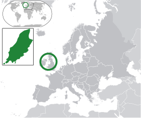
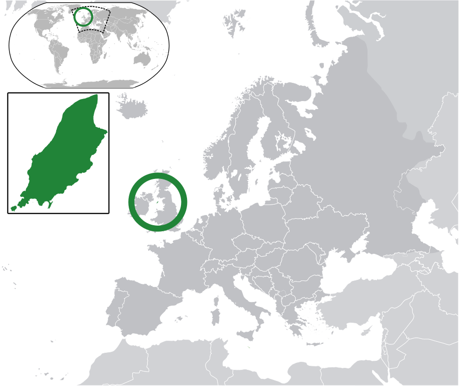
Map in English of the Isle of Man, with bounds of sheadings, towns, villages, districts and parishes. (Green) Isle of Man.
(Gray) Europe.
(Light-gray) The surrounding region.
The Full Map of the Isle of Man |
||
| दिनांक | |||
| स्रोत | Own work based on: IsleOfMan SheadingsAndParishes-en.svg | ||
| लेखक | Chipmunkdavis | ||
| परवानगी (या संचिकेचा पुनर्वापर करीत आहे) |
ही संचिका खालील परवान्याअंतर्गत आहे - क्रीएटिव्ह कॉमन्स Attribution-Share Alike 3.0 Unported.
|
||
| SVG genesis |
|
चढवल्याचे मुळ विवरण
This image is a derivative work of the following images:
- licensed with Cc-by-sa-3.0
- 2011-02-21T07:49:57Z Chipmunkdavis 2045x1720 (2394864 Bytes)
- IsleOfMan SheadingsAndParishes-en.svg licensed with Cc-by-sa-3.0,2.5,2.0,1.0, GFDL
- 2008-01-17T12:48:28Z Sémhur 1200x1100 (227618 Bytes) Update
- 2007-05-29T20:36:04Z Sémhur 0x0 (364350 Bytes) {{Information |Description=Map in English of the [[:en:Isle of Man|Isle of Man]], with bounds of sheadings, towns, villages, districts and parishes. |Source=Own work. Based on maps [[:Image:Isle of Man map-fr.svg]], [[:Image:
Uploaded with derivativeFX
संचिकेचा इतिहास
संचिकेची त्यावेळची आवृत्ती बघण्यासाठी त्या दिनांक/वेळेवर टिचकी द्या.
| दिनांक/वेळ | छोटे चित्र | आकार | सदस्य | प्रतिक्रीया | |
|---|---|---|---|---|---|
| सद्य | ११:४०, २ मार्च २०११ | | २,०४५ × १,७२० (२.२४ मे.बा.) | Chipmunkdavis | Redid inset |
| ११:३३, २ मार्च २०११ |  | २,०४५ × १,७२० (२.२२ मे.बा.) | Chipmunkdavis | Without inset | |
| ११:३१, २ मार्च २०११ |  | २,०४५ × १,७२० (२.२२ मे.बा.) | Chipmunkdavis | One more try | |
| १४:३३, २१ फेब्रुवारी २०११ |  | २,०४५ × १,७२० (२.२२ मे.बा.) | Chipmunkdavis | Grouped inset | |
| १४:३०, २१ फेब्रुवारी २०११ |  | २,०४५ × १,७२० (२.२२ मे.बा.) | Chipmunkdavis | File not appearing properly, reuploading | |
| १३:३६, २१ फेब्रुवारी २०११ |  | २,०४५ × १,७२० (२.२२ मे.बा.) | Chipmunkdavis | {{Information |Description={{en|1={{Europe-SVG-en|Northern Cyprus}}}} {{en|1=The Full Map of Jersey}} Map in english of the Isle of Man, with bounds of sheadings, towns, villages, districts and parishes. |Source=*[[:File:Europe-Jersey. |
दुवे
या चित्राशी जोडलेली पृष्ठे नाहीत.
जागतिक संचिका उपयोग
संचिकाचे इतर विकिपीडियावरील वापरः
- ace.wikipedia.org वरील उपयोग
- an.wikipedia.org वरील उपयोग
- ar.wikipedia.org वरील उपयोग
- arz.wikipedia.org वरील उपयोग
- ast.wikipedia.org वरील उपयोग
- az.wikipedia.org वरील उपयोग
- ba.wikipedia.org वरील उपयोग
- bew.wikipedia.org वरील उपयोग
- bg.wikipedia.org वरील उपयोग
- bh.wikipedia.org वरील उपयोग
- bn.wikipedia.org वरील उपयोग
- ca.wikipedia.org वरील उपयोग
- cdo.wikipedia.org वरील उपयोग
- cs.wikipedia.org वरील उपयोग
- diq.wikipedia.org वरील उपयोग
- en.wikipedia.org वरील उपयोग
- eo.wikipedia.org वरील उपयोग
- es.wikipedia.org वरील उपयोग
- ext.wikipedia.org वरील उपयोग
- fi.wiktionary.org वरील उपयोग
- fr.wikipedia.org वरील उपयोग
- ga.wikipedia.org वरील उपयोग
- gl.wikipedia.org वरील उपयोग
- hak.wikipedia.org वरील उपयोग
- ha.wikipedia.org वरील उपयोग
- he.wikipedia.org वरील उपयोग
- ia.wikipedia.org वरील उपयोग
- incubator.wikimedia.org वरील उपयोग
- it.wikipedia.org वरील उपयोग
- ja.wikipedia.org वरील उपयोग
- kab.wikipedia.org वरील उपयोग
- kk.wikipedia.org वरील उपयोग
- km.wikipedia.org वरील उपयोग
- la.wikipedia.org वरील उपयोग
- lb.wikipedia.org वरील उपयोग
- lij.wikipedia.org वरील उपयोग
- lv.wikipedia.org वरील उपयोग
या संचिकेचे अधिक वैश्विक उपयोग पहा