
चित्र:WestAfrica1625.png
यापेक्षा मोठे चित्र उपलब्ध नाही.
WestAfrica1625.png (४९८ × ३०६ पिक्सेल, संचिकेचा आकार: ३१ कि.बा., MIME प्रकार: image/png)

|
This historical map image could be re-created using vector graphics as an SVG file. This has several advantages; see Commons:Media for cleanup for more information. If an SVG form of this image is available, please upload it and afterwards replace this template with
{{vector version available|new image name}}.
It is recommended to name the SVG file “WestAfrica1625.svg”—then the template Vector version available (or Vva) does not need the new image name parameter. |
सारांश
| वर्णन |
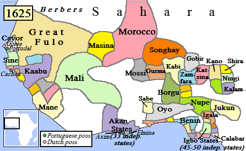
English: Map of West Africa, AD 1625.
(Partially based on Atlas of World History (2007) - Early modern Africa, map.) |
| दिनांक | |
| स्रोत | स्वतःचे काम |
| लेखक | Gabagool |
परवाना:
I, the copyright holder of this work, hereby publish it under the following license:
ही संचिका खालील परवान्याअंतर्गत आहे - क्रीएटिव्ह कॉमन्स Attribution 3.0 Unported.
- तुम्ही मुक्त आहात.
- सामायिक करा – नक्कल, वितरण आणि पारेषित करण्यास
- पुर्नमिश्रीत करण्यास – काम गरजेनुसार अनुकुलीत करण्यास
- खालील अटींच्या अधिन राहून:
- रोपण – आपण योग्य क्रेडिट देणे आवश्यक आहे, परवान्यास दुवा प्रदान करणे आवश्यक आहे, आणि बदल केले गेले आहेत हे दर्शविणे आवश्यक आहे. आपण हे कोणत्याही वाजवी मार्गाने करू शकता, परंतु परवानाधारक आपल्यास किंवा आपल्या वापरास मान्यता देतो अशा कोणत्याही मार्गाने नाही.
संचिकेचा इतिहास
संचिकेची त्यावेळची आवृत्ती बघण्यासाठी त्या दिनांक/वेळेवर टिचकी द्या.
| दिनांक/वेळ | छोटे चित्र | आकार | सदस्य | प्रतिक्रीया | |
|---|---|---|---|---|---|
| सद्य | २३:१२, ५ मे २०१० | | ४९८ × ३०६ (३१ कि.बा.) | Omar-Toons | Reverted to version as of 00:15, 16 June 2009 |
| २३:३५, २० एप्रिल २०१० |  | ४९७ × ३०६ (३१ कि.बा.) | Bokpasa | Saadi dynasty and Tuaregs | |
| ०५:४५, १६ जून २००९ |  | ४९८ × ३०६ (३१ कि.बा.) | Gabagool | rm lines | |
| ०१:२७, २० एप्रिल २००९ |  | ४९८ × ३०६ (३२ कि.बा.) | Gabagool | {{Information |Description={{en|1=Map of West Africa, AD 1625. (Partially based on ''Atlas of World History'' (2007) - Early modern Africa, map.)}} |Source=Own work by uploader |Author=Gabagool |Date=2009-04-19 |Permission= |other_versi |
दुवे
खालील पाने या संचिकेला जोडली आहेत:
जागतिक संचिका उपयोग
संचिकाचे इतर विकिपीडियावरील वापरः
- af.wikipedia.org वरील उपयोग
- als.wikipedia.org वरील उपयोग
- ar.wikipedia.org वरील उपयोग
- azb.wikipedia.org वरील उपयोग
- bn.wikipedia.org वरील उपयोग
- ca.wikipedia.org वरील उपयोग
- da.wikipedia.org वरील उपयोग
- de.wikipedia.org वरील उपयोग
- en.wikipedia.org वरील उपयोग
- Mali Empire
- Songhai Empire
- Songhai people
- Sahelian kingdoms
- Oyo Empire
- History of West Africa
- Islamization of the Sudan region
- Kaabu
- Empire of Great Fulo
- Dendi (province)
- Legends of Africa
- Timeline of Nigerian history
- List of kingdoms in Africa throughout history
- Military history of the Mali Empire
- Nigerian traditional rulers
- User:OnBeyondZebrax/sandbox/African history
- User:Tisquesusa/sandbox9
- The Songhai
- Medieval and early modern Africa
- en.wikibooks.org वरील उपयोग
या संचिकेचे अधिक वैश्विक उपयोग पहा