
चित्र:Tsunami travel time Valdivia 1960.jpg
या झलकेचा आकार: ६४४ × ६०० पिक्सेल पिक्सेल. इतर resolutions: २५८ × २४० पिक्सेल | ५१५ × ४८० पिक्सेल | ८५९ × ८०० पिक्सेल.
मूळ संचिका (८५९ × ८०० पिक्सेल, संचिकेचा आकार: ३२४ कि.बा., MIME प्रकार: image/jpeg)
सारांश
Español: Mapa con el avance del tsunami del terremoto de Valdivia, Chile, 22 de mayo de 1960
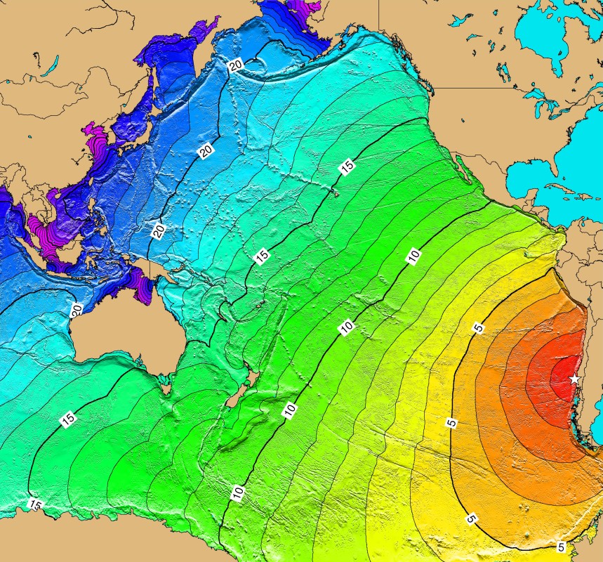
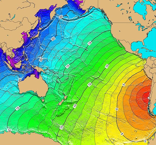
English: Tsunami-Travel-Time of the earthquake of Valdivia, Chile, May 22, 1960. Contours are one hour intervals.
- Source
- was NGDC Tsunami-Travel-Time Maps ; currently see https://earthquake.usgs.gov/earthquakes/world/events/1960_05_22_tsunami.php
परवाना:
This image is in the public domain because it contains materials that originally came from the U.S. National Oceanic and Atmospheric Administration, taken or made as part of an employee's official duties.
|
संचिकेचा इतिहास
संचिकेची त्यावेळची आवृत्ती बघण्यासाठी त्या दिनांक/वेळेवर टिचकी द्या.
| दिनांक/वेळ | छोटे चित्र | आकार | सदस्य | प्रतिक्रीया | |
|---|---|---|---|---|---|
| सद्य | ०६:४८, ११ मार्च २००६ | | ८५९ × ८०० (३२४ कि.बा.) | B1mbo | {{es|Mapa con el avance del tsunami del terremoto de Valdivia, 22 de mayo de 1960}} '''Source:''' [http://www.ngdc.noaa.gov/seg/hazard/img/1960_0522.jpg NGDC Tsunami-Travel-Time Maps] Category:Chile Category:Tsunamis ==Licensing== {{PD-USGov-NO |
दुवे
या चित्राशी जोडलेली पृष्ठे नाहीत.
जागतिक संचिका उपयोग
संचिकाचे इतर विकिपीडियावरील वापरः
- ca.wikipedia.org वरील उपयोग
- ckb.wikipedia.org वरील उपयोग
- cs.wikipedia.org वरील उपयोग
- de.wikipedia.org वरील उपयोग
- en.wikipedia.org वरील उपयोग
- en.wikiquote.org वरील उपयोग
- es.wikipedia.org वरील उपयोग
- fr.wikipedia.org वरील उपयोग
- he.wikipedia.org वरील उपयोग
- id.wikipedia.org वरील उपयोग
- ja.wikipedia.org वरील उपयोग
- ko.wikipedia.org वरील उपयोग
- nl.wikipedia.org वरील उपयोग
- nn.wikipedia.org वरील उपयोग
- pl.wikipedia.org वरील उपयोग
- pt.wikipedia.org वरील उपयोग
- sh.wikipedia.org वरील उपयोग
- sk.wikipedia.org वरील उपयोग
- th.wikipedia.org वरील उपयोग
- tr.wikipedia.org वरील उपयोग
- uk.wikipedia.org वरील उपयोग
- zh.wikipedia.org वरील उपयोग