
चित्र:Smithisland milt.jpg

या झलकेचा आकार: ५४९ × ६०० पिक्सेल पिक्सेल. इतर resolutions: २२० × २४० पिक्सेल | ४३९ × ४८० पिक्सेल | ७०३ × ७६८ पिक्सेल | १,०२४ × १,११९ पिक्सेल.
मूळ संचिका (१,०२४ × १,११९ पिक्सेल, संचिकेचा आकार: २०९ कि.बा., MIME प्रकार: image/jpeg)
सारांश
| वर्णन |
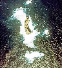
English: Aerial Photograph of Smith Island at Izu Islands in 1978.
日本語: 須美寿島の航空写真(1978年)。1990年代に島が部分的に崩落したため、現在とは形状が異なっている。 |
| दिनांक | |
| स्रोत |
日本語: 国土画像情報(カラー空中写真) |
| लेखक |
日本語: 国土交通省 |
परवाना:

|
The copyright holder of this file, the Ministry of Land, Infrastructure, Transport and Tourism of Japan, allows anyone to use it for any purpose, provided that the copyright holder is properly attributed. Redistribution, derivative work, commercial use, and all other use is permitted. |
रोपण:
Copyright © National Land Image Information (Color Aerial Photographs), Ministry of Land, Infrastructure, Transport and Tourism
|
 |
This image is copyrighted by the Ministry of Land, Infrastructure, Transport and Tourism of Japan. For terms of use, see the stipulation to use of National Land Information (in Japanese) and message from MLIT (in Japanese and English). When you display this image on an article, include the following phrase in the description: "Made based on National Land Image Information (Color Aerial Photographs), Ministry of Land, Infrastructure, Transport and Tourism".
|
संचिकेचा इतिहास
संचिकेची त्यावेळची आवृत्ती बघण्यासाठी त्या दिनांक/वेळेवर टिचकी द्या.
| दिनांक/वेळ | छोटे चित्र | आकार | सदस्य | प्रतिक्रीया | |
|---|---|---|---|---|---|
| सद्य | २०:०८, ९ मे २००६ | | १,०२४ × १,११९ (२०९ कि.बा.) | Tdk~commonswiki | Aerial Photograph of Smith Island at Izu Islands in 1978.{{AerialPhotograph-mlitJP}} |
दुवे
खालील पाने या संचिकेला जोडली आहेत:
जागतिक संचिका उपयोग
संचिकाचे इतर विकिपीडियावरील वापरः
- arz.wikipedia.org वरील उपयोग
- az.wikipedia.org वरील उपयोग
- ceb.wikipedia.org वरील उपयोग
- ckb.wikipedia.org वरील उपयोग
- cs.wikipedia.org वरील उपयोग
- de.wikipedia.org वरील उपयोग
- en.wikipedia.org वरील उपयोग
- es.wikipedia.org वरील उपयोग
- fa.wikipedia.org वरील उपयोग
- frr.wikipedia.org वरील उपयोग
- he.wikipedia.org वरील उपयोग
- hy.wikipedia.org वरील उपयोग
- it.wikipedia.org वरील उपयोग
- ja.wikipedia.org वरील उपयोग
- ko.wikipedia.org वरील उपयोग
- lt.wikipedia.org वरील उपयोग
- no.wikipedia.org वरील उपयोग
- pt.wikipedia.org वरील उपयोग
- ru.wikipedia.org वरील उपयोग
- sk.wikipedia.org वरील उपयोग
- tr.wikipedia.org वरील उपयोग
- uk.wikipedia.org वरील उपयोग
- www.wikidata.org वरील उपयोग
- zh.wikipedia.org वरील उपयोग