
चित्र:SatavahanaMap.jpg

या झलकेचा आकार: ४६७ × ५९९ पिक्सेल पिक्सेल. इतर resolutions: १८७ × २४० पिक्सेल | ३७४ × ४८० पिक्सेल | ५९९ × ७६८ पिक्सेल | १,१२३ × १,४४० पिक्सेल.
मूळ संचिका (१,१२३ × १,४४० पिक्सेल, संचिकेचा आकार: ३२७ कि.बा., MIME प्रकार: image/jpeg)

|
This map has been uploaded by Electionworld from en.wikipedia.org to enable the |

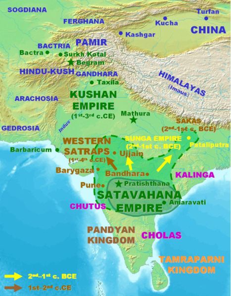
Approximate extent of the Satavahana Empire.
Personal map, 2005. Released in the Public Domain.
| This work has been released into the public domain by its author, PHG. This applies worldwide. असे करणे काही देशांमधे कायद्यानुसार शक्य नसू शकते. असे असल्यास : |
संचिकेचा इतिहास
संचिकेची त्यावेळची आवृत्ती बघण्यासाठी त्या दिनांक/वेळेवर टिचकी द्या.
| दिनांक/वेळ | छोटे चित्र | आकार | सदस्य | प्रतिक्रीया | |
|---|---|---|---|---|---|
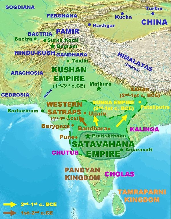
| सद्य | १९:३९, १८ मार्च २००७ | | १,१२३ × १,४४० (३२७ कि.बा.) | World Imaging | Better map, personal creation. |
| ०४:५१, १४ डिसेंबर २००६ |  | ३९५ × ४३२ (२९ कि.बा.) | Electionworld | {{ew|en|PHG}} {{POV-map}} Approximate extent of the Satavahana Empire. Personal map, 2005. Released in the Public Domain. {{pd}} |
दुवे
खालील पाने या संचिकेला जोडली आहेत:
जागतिक संचिका उपयोग
संचिकाचे इतर विकिपीडियावरील वापरः
- ba.wikipedia.org वरील उपयोग
- bn.wikipedia.org वरील उपयोग
- ca.wikipedia.org वरील उपयोग
- cs.wikipedia.org वरील उपयोग
- cv.wikipedia.org वरील उपयोग
- de.wikipedia.org वरील उपयोग
- en.wikipedia.org वरील उपयोग
- es.wikipedia.org वरील उपयोग
- eu.wikipedia.org वरील उपयोग
- fa.wikipedia.org वरील उपयोग
- fi.wikipedia.org वरील उपयोग
- fr.wikipedia.org वरील उपयोग
- hi.wikipedia.org वरील उपयोग
- hy.wikipedia.org वरील उपयोग
- id.wikipedia.org वरील उपयोग
- id.wikibooks.org वरील उपयोग
- it.wikipedia.org वरील उपयोग
- kn.wikipedia.org वरील उपयोग
- ko.wikipedia.org वरील उपयोग
- lt.wikipedia.org वरील उपयोग
- nl.wikipedia.org वरील उपयोग
- pnb.wikipedia.org वरील उपयोग
- ru.wikipedia.org वरील उपयोग
- sa.wikipedia.org वरील उपयोग
- sh.wikipedia.org वरील उपयोग
- si.wikipedia.org वरील उपयोग
- sq.wikipedia.org वरील उपयोग
- sr.wikipedia.org वरील उपयोग
- te.wikipedia.org वरील उपयोग
- th.wikipedia.org वरील उपयोग
- tl.wikipedia.org वरील उपयोग
- tt.wikipedia.org वरील उपयोग
- uk.wikipedia.org वरील उपयोग
- ur.wikipedia.org वरील उपयोग
- www.wikidata.org वरील उपयोग
या संचिकेचे अधिक वैश्विक उपयोग पहा