
चित्र:Sakarya districts.png
या झलकेचा आकार: ७७८ × ६०० पिक्सेल पिक्सेल. इतर resolutions: ३११ × २४० पिक्सेल | ६२३ × ४८० पिक्सेल | ९९६ × ७६८ पिक्सेल | १,०५३ × ८१२ पिक्सेल.
मूळ संचिका (१,०५३ × ८१२ पिक्सेल, संचिकेचा आकार: ८८ कि.बा., MIME प्रकार: image/png)
सारांश
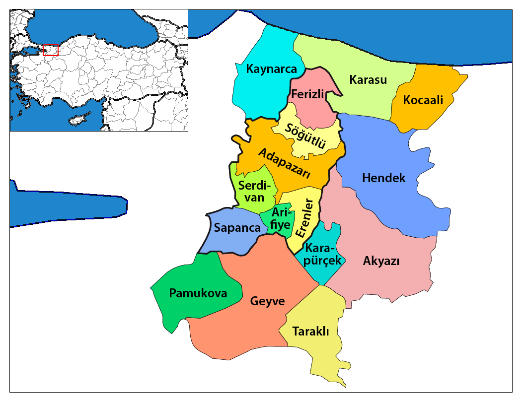
| वर्णन | Map of the districts of Sakarya province in Turkey. Created by Rarelibra 17:12, 4 December 2006 (UTC) for public domain use, using MapInfo Professional v8.5 and various mapping resources. Edited by One Homo Sapiens Corrected text where İ,Ş,ı,ğ,or ş occurs in name. Source: [statoids-com]. Increased font size and enhanced color differences among adjacent districts. |
| दिनांक | डिसेंबर ४, इ.स. २००६ (original upload date) |
| स्रोत | No machine-readable source provided. Own work assumed (based on copyright claims). |
| लेखक | No machine-readable author provided. Rarelibra assumed (based on copyright claims). |
परवाना:
| I, the copyright holder of this work, release this work into the public domain. This applies worldwide. असे करणे काही देशांमधे कायद्यानुसार शक्य नसू शकते. असे असल्यास : मी कोणालाही कोणत्याही कारणासाठी हे काम वापरण्याचे अधिकार कोणत्याही बंधनाशिवाय जर अशी बंधने कायद्याने बंधनकारक नसतीलतर देत आहोत. |
संचिकेचा इतिहास
संचिकेची त्यावेळची आवृत्ती बघण्यासाठी त्या दिनांक/वेळेवर टिचकी द्या.
| दिनांक/वेळ | छोटे चित्र | आकार | सदस्य | प्रतिक्रीया | |
|---|---|---|---|---|---|
| सद्य | ००:१७, २० जानेवारी २०१४ | | १,०५३ × ८१२ (८८ कि.बा.) | Chumwa | Nach der letzten Gebietsreform ist der zentrale Landkreis (in der Karte zuvor "Sakarya Merkez") aufgeteilt worden in: Adapazarı, Arifiye, Erenler und Serdivan. Die Kreise, die zur Großstadtkommune Sakarya gehören, sind umrandet worden. |
| ०७:२८, २९ डिसेंबर २००८ |  | १,०५६ × ८१६ (३३ कि.बा.) | One Homo Sapiens | Corrected text where İ,Ş,ı,ğ,or ş occurs in name. Source: [statoids-com]. Increased font size and enhanced color differences among adjacent districts. | |
| २१:३०, १२ एप्रिल २००७ |  | ७७६ × ६०० (११० कि.बा.) | KureCewlik81 | ||
| २२:४२, ४ डिसेंबर २००६ |  | १,०५६ × ८१६ (३४ कि.बा.) | Rarelibra | Map of the districts of Sakarya province in Turkey. Created by ~~~~ for public domain use, using MapInfo Professional v8.5 and various mapping resources. |
दुवे
खालील पाने या संचिकेला जोडली आहेत:
जागतिक संचिका उपयोग
संचिकाचे इतर विकिपीडियावरील वापरः
- ar.wikipedia.org वरील उपयोग
- arz.wikipedia.org वरील उपयोग
- ast.wikipedia.org वरील उपयोग
- azb.wikipedia.org वरील उपयोग
- az.wikipedia.org वरील उपयोग
- ca.wikipedia.org वरील उपयोग
- ceb.wikipedia.org वरील उपयोग
- ce.wikipedia.org वरील उपयोग
- cs.wikipedia.org वरील उपयोग
- cv.wikipedia.org वरील उपयोग
- de.wikipedia.org वरील उपयोग
- diq.wikipedia.org वरील उपयोग
- en.wikipedia.org वरील उपयोग
या संचिकेचे अधिक वैश्विक उपयोग पहा