
चित्र:Pre Historic Mid Krishna-Tungabhadra Valley sites.jpg
या झलकेचा आकार: ७२६ × ६०० पिक्सेल पिक्सेल. इतर resolutions: २९१ × २४० पिक्सेल | ५८१ × ४८० पिक्सेल | ९२९ × ७६८ पिक्सेल | १,२३९ × १,०२४ पिक्सेल | २,३३८ × १,९३२ पिक्सेल.
मूळ संचिका (२,३३८ × १,९३२ पिक्सेल, संचिकेचा आकार: ८७६ कि.बा., MIME प्रकार: image/jpeg)

|
This historical map image could be re-created using vector graphics as an SVG file. This has several advantages; see Commons:Media for cleanup for more information. If an SVG form of this image is available, please upload it and afterwards replace this template with
{{vector version available|new image name}}.
It is recommended to name the SVG file “Pre Historic Mid Krishna-Tungabhadra Valley sites.svg”—then the template Vector version available (or Vva) does not need the new image name parameter. |


सारांश
| वर्णन |
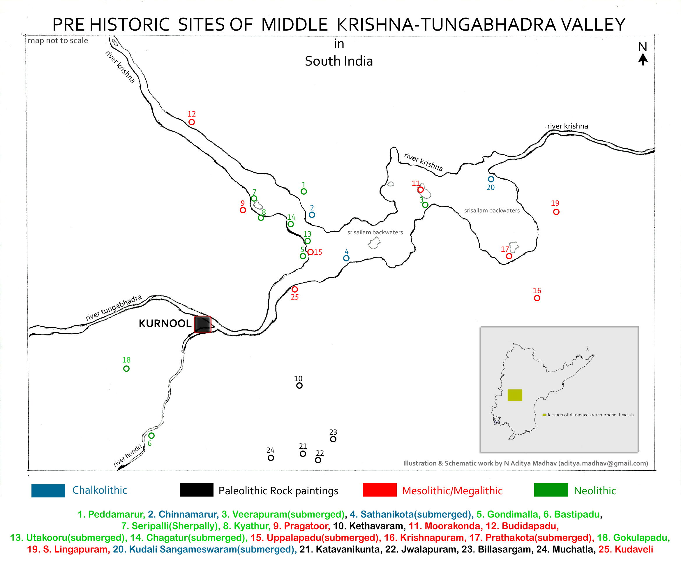
English: Pre Historic Mid Krishna-Tungabhadra Valley sites are:
1. Peddamarur, 2. Chinnamarur, 3. Veerapuram(submerged), 4. Sathanikota(submerged), 5. Gondimalla, 6. Bastipadu, 7. Seripalli(Sherpally), 8. Kyathur, 9. Pragatoor, 10. Kethavaram, 11. Moorakonda, 12. Budidapadu, 13. Utakooru(submerged), 14. Chagatur(submerged), 15. Uppalapadu(submerged), 16. Krishnapuram, 17. Prathakota(submerged), 18. Gokulapadu, 19. S. Lingapuram, 20. Kudali Sangameswaram(submerged), 21. Katavanikunta, 22. Jwalapuram, 23. Billasargam, 24. Muchatla, 25. Kudaveli Note: The map is created for information and educational purposes. People using the map outside Wikipedia projects are requested to attribute it properly. |
| दिनांक | |
| स्रोत | स्वतःचे काम |
| लेखक | Adityamadhav83 |
Data collected from Department of Archaeology and Museums, Hyderabad, Andhra Pradesh and Journals on Proto Historic culture and settlements in Andhra Pradesh.
परवाना:
I, the copyright holder of this work, hereby publish it under the following license:
ही संचिका खालील परवान्याअंतर्गत आहे - क्रीएटिव्ह कॉमन्स Attribution-Share Alike 3.0 Unported.
- तुम्ही मुक्त आहात.
- सामायिक करा – नक्कल, वितरण आणि पारेषित करण्यास
- पुर्नमिश्रीत करण्यास – काम गरजेनुसार अनुकुलीत करण्यास
- खालील अटींच्या अधिन राहून:
- रोपण – आपण योग्य क्रेडिट देणे आवश्यक आहे, परवान्यास दुवा प्रदान करणे आवश्यक आहे, आणि बदल केले गेले आहेत हे दर्शविणे आवश्यक आहे. आपण हे कोणत्याही वाजवी मार्गाने करू शकता, परंतु परवानाधारक आपल्यास किंवा आपल्या वापरास मान्यता देतो अशा कोणत्याही मार्गाने नाही.
- जसेहोते-वाटातसेच (शेअर अलाईक) – जर तुम्ही या कामात काही बदल केलात, काटछाट केलीत, किंवा भर घातली, तर असे करून बनलेले नवीन काम तुम्ही केवळ या किंवा यासारख्याच परवान्याअंतर्गत प्रसारित करू शकतात.
संचिकेचा इतिहास
संचिकेची त्यावेळची आवृत्ती बघण्यासाठी त्या दिनांक/वेळेवर टिचकी द्या.
| दिनांक/वेळ | छोटे चित्र | आकार | सदस्य | प्रतिक्रीया | |
|---|---|---|---|---|---|
| सद्य | १२:२५, १० मे २०१३ | | २,३३८ × १,९३२ (८७६ कि.बा.) | Adityamadhav83 | Location in Andhra Pradesh state included in the illustration |
| ०१:०१, २७ एप्रिल २०१३ |  | २,३३८ × १,९३२ (८४८ कि.बा.) | Adityamadhav83 | User created page with UploadWizard |
दुवे
खालील पाने या संचिकेला जोडली आहेत:
जागतिक संचिका उपयोग
संचिकाचे इतर विकिपीडियावरील वापरः
- ar.wikipedia.org वरील उपयोग
- bn.wikipedia.org वरील उपयोग
- ca.wikipedia.org वरील उपयोग
- de.wikipedia.org वरील उपयोग
- en.wikipedia.org वरील उपयोग
- es.wikipedia.org वरील उपयोग
- fr.wikipedia.org वरील उपयोग
- kn.wikipedia.org वरील उपयोग
- pa.wikipedia.org वरील उपयोग
- pnb.wikipedia.org वरील उपयोग
- si.wikipedia.org वरील उपयोग
- sr.wikipedia.org वरील उपयोग
- ta.wikipedia.org वरील उपयोग
- te.wikipedia.org वरील उपयोग
- tr.wikipedia.org वरील उपयोग
- ur.wikipedia.org वरील उपयोग
- zh.wikipedia.org वरील उपयोग