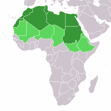
चित्र:LocationNorthernAfrica.png
LocationNorthernAfrica.png (३५९ × ३५९ पिक्सेल, संचिकेचा आकार: ८ कि.बा., MIME प्रकार: image/png)
संचिकेचा इतिहास
संचिकेची त्यावेळची आवृत्ती बघण्यासाठी त्या दिनांक/वेळेवर टिचकी द्या.
| दिनांक/वेळ | छोटे चित्र | आकार | सदस्य | प्रतिक्रीया | |
|---|---|---|---|---|---|
| सद्य | १८:४६, ११ नोव्हेंबर २०२२ |  | ३५९ × ३५९ (८ कि.बा.) | ColorfulSmoke | . |
| १७:२४, ११ नोव्हेंबर २०२२ |  | ३६० × ३५९ (८ कि.बा.) | ColorfulSmoke | ||
| २२:२७, १७ मार्च २०१८ |  | ३६० × ३९२ (१० कि.बा.) | Maphobbyist | Montenegro border | |
| २३:४९, १० फेब्रुवारी २०१४ |  | ३६० × ३९२ (८ कि.बा.) | Knyaz-1988 | New version | |
| १०:३५, १२ जानेवारी २०१३ |  | ३६० × ३९२ (१३ कि.बा.) | Kuohatti | Reverted to version as of 21:04, 9 July 2011. According to http://unstats.un.org/unsd/methods/m49/m49regin.htm#africa UN doesn't count South Sudan in North Africa. | |
| १८:१७, २० जुलै २०११ |  | ३६० × ३९२ (८ कि.बा.) | Kahusi | See http://unstats.un.org/unsd/methods/m49/m49regin.htm | |
| ०२:३४, १० जुलै २०११ |  | ३६० × ३९२ (१३ कि.बा.) | Maphobbyist | South Sudan has become independent on July 9, 2011. Sudan and South Sudan are shown with the new international border between them. | |
| ००:२५, २८ मे २००९ |  | ३६० × ३९२ (१४ कि.बा.) | Elmondo21st | Reverted to version as of 08:13, 11 December 2007 | |
| २३:४३, ५ एप्रिल २००९ |  | ३६० × ३९२ (१४ कि.बा.) | Elmondo21st | The map of the northern Africa is about 5 main countries; Morocco, Algeria, Tunisia, Libya and Egypt. The greater northern Africa includes the Sahara countries among them Sudan. | |
| १३:४३, ११ डिसेंबर २००७ |  | ३६० × ३९२ (१४ कि.बा.) | Hoshie | added Cabinda (Angola) |
दुवे
खालील पाने या संचिकेला जोडली आहेत:
जागतिक संचिका उपयोग
संचिकाचे इतर विकिपीडियावरील वापरः
- ace.wikipedia.org वरील उपयोग
- af.wikipedia.org वरील उपयोग
- als.wikipedia.org वरील उपयोग
- am.wikipedia.org वरील उपयोग
- ar.wikipedia.org वरील उपयोग
- ليبيا
- جيبوتي
- موريتانيا
- تونس
- السودان
- الصحراء الغربية
- أنغولا
- أوغندا
- إسبانيا
- تشاد
- النيجر
- مالي
- السنغال
- غامبيا
- غينيا بيساو
- غينيا
- سيراليون
- ليبيريا
- غانا
- توغو
- بنين
- بوركينا فاسو
- الصومال
- كينيا
- تنزانيا
- الغابون
- زامبيا
- موزمبيق
- زيمبابوي
- البرتغال
- الكاميرون
- جمهورية الكونغو الديمقراطية
- بوتسوانا
- جنوب إفريقيا
- جمهورية إفريقيا الوسطى
- جمهورية الكونغو
- سيشل
- ناميبيا
- مدغشقر
- ليسوتو
- موريشيوس
या संचिकेचे अधिक वैश्विक उपयोग पहा


