
चित्र:Ahmedabad 1855.jpg

या झलकेचा आकार: ८०० × ५४५ पिक्सेल पिक्सेल. इतर resolutions: ३२० × २१८ पिक्सेल | ६४० × ४३६ पिक्सेल | १,०२४ × ६९८ पिक्सेल | १,२८० × ८७३ पिक्सेल | २,३२५ × १,५८५ पिक्सेल.
मूळ संचिका (२,३२५ × १,५८५ पिक्सेल, संचिकेचा आकार: ९१७ कि.बा., MIME प्रकार: image/jpeg)
सारांश
| वर्णन |
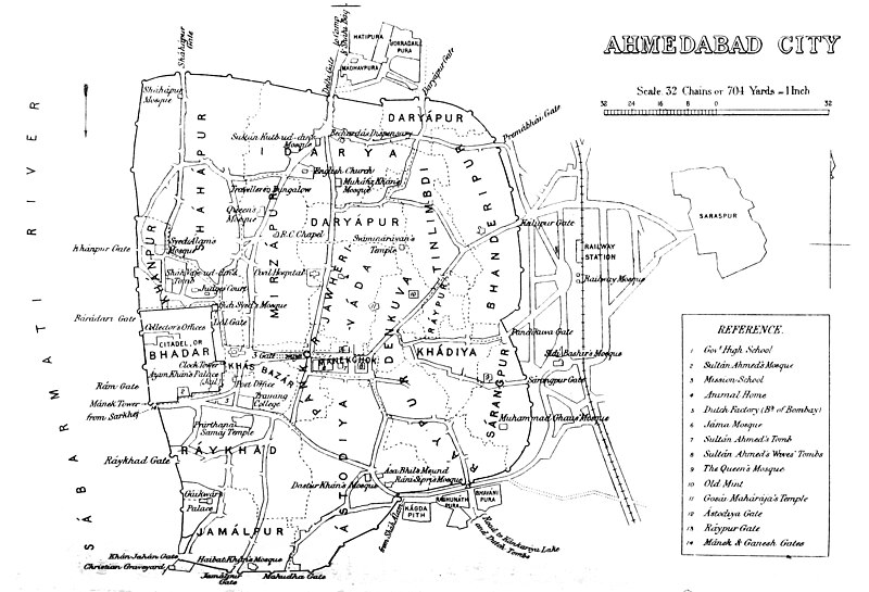
Deutsch: Alte Karte der Stadtumwallung von Ahmedabad, einschließlich Lage der Stadttore. Der Bahnhof befindet sich außerhalb des Festungsgeländes.
English: Map of Ahmedabad |
|||||||||
| दिनांक | ||||||||||
| स्रोत | Gazetteer of the Bombay Presidency. (1896) by James M. Campbell | |||||||||
| रचनाकार |
Various |
|||||||||
| Geotemporal data | ||||||||||
| Bounding box |
|
|||||||||
| Georeferencing | ||||||||||
परवाना:
|
This work is in the public domain in its country of origin and other countries and areas where the copyright term is the author's life plus 70 years or fewer. This work is in the public domain in the United States because it was published (or registered with the U.S. Copyright Office) before January 1, 1929. | |
| This file has been identified as being free of known restrictions under copyright law, including all related and neighboring rights. | |
संचिकेचा इतिहास
संचिकेची त्यावेळची आवृत्ती बघण्यासाठी त्या दिनांक/वेळेवर टिचकी द्या.
| दिनांक/वेळ | छोटे चित्र | आकार | सदस्य | प्रतिक्रीया | |
|---|---|---|---|---|---|
| सद्य | २०:४८, ५ नोव्हेंबर २०१४ | | २,३२५ × १,५८५ (९१७ कि.बा.) | Shyamal | User created page with UploadWizard |
दुवे
खालील पाने या संचिकेला जोडली आहेत:
जागतिक संचिका उपयोग
संचिकाचे इतर विकिपीडियावरील वापरः
- en.wikipedia.org वरील उपयोग
- fa.wikipedia.org वरील उपयोग
- gu.wikipedia.org वरील उपयोग
- kn.wikipedia.org वरील उपयोग
- ur.wikipedia.org वरील उपयोग
- vi.wikipedia.org वरील उपयोग
- zh.wikipedia.org वरील उपयोग