
चित्र:Sinai-peninsula-map.jpg

या झलकेचा आकार: ४८३ × ६०० पिक्सेल पिक्सेल. इतर resolutions: १९३ × २४० पिक्सेल | ३८७ × ४८० पिक्सेल | ९४१ × १,१६८ पिक्सेल.
मूळ संचिका (९४१ × १,१६८ पिक्सेल, संचिकेचा आकार: ६६५ कि.बा., MIME प्रकार: image/jpeg)
فلسطين
सारांश
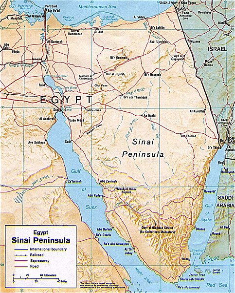
| वर्णन | Shaded relief map of the Sinai Peninsula, 1992, produced by the U.S. Central Intelligence Agency. |
| दिनांक | |
| स्रोत | University of Texas Libraries, Perry-Castañeda Library Map Collection: Egypt Maps |
| लेखक | CIA |
| इतर आवृत्तींस |
|


परवाना:
| This image is a work of a Central Intelligence Agency employee, taken or made as part of that person's official duties. As a Work of the United States Government, this image or media is in the public domain in the United States.
|

|
संचिकेचा इतिहास
संचिकेची त्यावेळची आवृत्ती बघण्यासाठी त्या दिनांक/वेळेवर टिचकी द्या.
| दिनांक/वेळ | छोटे चित्र | आकार | सदस्य | प्रतिक्रीया | |
|---|---|---|---|---|---|
| सद्य | ०२:१५, १३ मे २०११ | | ९४१ × १,१६८ (६६५ कि.बा.) | Ras67 | cropped |
| ०४:२८, ५ मार्च २००७ |  | ९५६ × १,१९६ (३०७ कि.बा.) | Joao Xavier | Map of the Sinai Peninsula. (U.S. Central Intelligence Agency, https://www.cia.gov/cia/publications/mapspub/index.shtml) originally found on University of Texas library website (http://www.lib.utexas.edu/maps/middle_east_and_asia/sinai.jpg) and claimed as |
दुवे
खालील पाने या संचिकेला जोडली आहेत:
जागतिक संचिका उपयोग
संचिकाचे इतर विकिपीडियावरील वापरः
- af.wikipedia.org वरील उपयोग
- als.wikipedia.org वरील उपयोग
- ar.wikipedia.org वरील उपयोग
- ast.wikipedia.org वरील उपयोग
- azb.wikipedia.org वरील उपयोग
- az.wikipedia.org वरील उपयोग
- az.wiktionary.org वरील उपयोग
- ba.wikipedia.org वरील उपयोग
- bn.wikipedia.org वरील उपयोग
- bs.wikipedia.org वरील उपयोग
- ca.wikipedia.org वरील उपयोग
- cs.wikipedia.org वरील उपयोग
- da.wikipedia.org वरील उपयोग
- de.wikipedia.org वरील उपयोग
- de.wikinews.org वरील उपयोग
- de.wiktionary.org वरील उपयोग
- diq.wikipedia.org वरील उपयोग
- el.wikipedia.org वरील उपयोग
- el.wiktionary.org वरील उपयोग
- en.wikipedia.org वरील उपयोग
- eo.wikipedia.org वरील उपयोग
- es.wikipedia.org वरील उपयोग
- eu.wikipedia.org वरील उपयोग
या संचिकेचे अधिक वैश्विक उपयोग पहा