
चित्र:Ng-map.png
यापेक्षा मोठे चित्र उपलब्ध नाही.
Ng-map.png (३२९ × ३५२ पिक्सेल, संचिकेचा आकार: १२ कि.बा., MIME प्रकार: image/png)
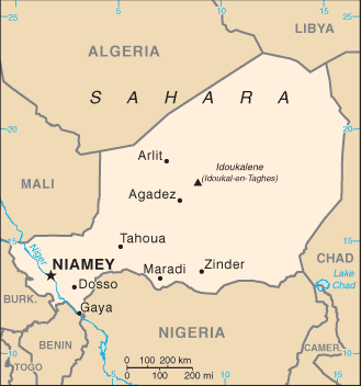
CIA map of Niger
This image is in the public domain because it contains materials that originally came from the United States Central Intelligence Agency's World Factbook.
|
 |
संचिकेचा इतिहास
संचिकेची त्यावेळची आवृत्ती बघण्यासाठी त्या दिनांक/वेळेवर टिचकी द्या.
| दिनांक/वेळ | छोटे चित्र | आकार | सदस्य | प्रतिक्रीया | |
|---|---|---|---|---|---|
| सद्य | ०२:२३, ५ मार्च २००५ | | ३२९ × ३५२ (१२ कि.बा.) | Alfio | CIA map of Niger |
दुवे
खालील पाने या संचिकेला जोडली आहेत:
जागतिक संचिका उपयोग
संचिकाचे इतर विकिपीडियावरील वापरः
- als.wikipedia.org वरील उपयोग
- be-tarask.wikipedia.org वरील उपयोग
- bn.wikipedia.org वरील उपयोग
- ca.wikipedia.org वरील उपयोग
- ckb.wikipedia.org वरील उपयोग
- da.wikipedia.org वरील उपयोग
- de.wikipedia.org वरील उपयोग
- dsb.wikipedia.org वरील उपयोग
- en.wikipedia.org वरील उपयोग
- en.wikinews.org वरील उपयोग
- es.wikipedia.org वरील उपयोग
- eu.wikipedia.org वरील उपयोग
- fa.wikipedia.org वरील उपयोग
- fi.wikipedia.org वरील उपयोग
- fi.wikivoyage.org वरील उपयोग
- gl.wikipedia.org वरील उपयोग
- he.wikipedia.org वरील उपयोग
- hif.wikipedia.org वरील उपयोग
- hu.wikipedia.org वरील उपयोग
- hu.wiktionary.org वरील उपयोग
- hy.wikipedia.org वरील उपयोग
- io.wikipedia.org वरील उपयोग
- it.wikipedia.org वरील उपयोग
- lfn.wikipedia.org वरील उपयोग
- mdf.wikipedia.org वरील उपयोग
- ms.wikipedia.org वरील उपयोग
- nds-nl.wikipedia.org वरील उपयोग
- nds.wikipedia.org वरील उपयोग
- no.wikipedia.org वरील उपयोग
- pl.wikipedia.org वरील उपयोग
- ps.wikipedia.org वरील उपयोग
- pt.wikipedia.org वरील उपयोग
- ru.wikipedia.org वरील उपयोग
- sg.wikipedia.org वरील उपयोग
- sg.wiktionary.org वरील उपयोग
- si.wikipedia.org वरील उपयोग
- sq.wikipedia.org वरील उपयोग
- sr.wikipedia.org वरील उपयोग
- stq.wikipedia.org वरील उपयोग
- sw.wikipedia.org वरील उपयोग
- te.wikipedia.org वरील उपयोग
- th.wikipedia.org वरील उपयोग
या संचिकेचे अधिक वैश्विक उपयोग पहा