
चित्र:International Hydrographic Organization countries.PNG

या झलकेचा आकार: ८०० × ३७० पिक्सेल पिक्सेल. इतर resolutions: ३२० × १४८ पिक्सेल | ६४० × २९६ पिक्सेल | १,३५० × ६२५ पिक्सेल.
मूळ संचिका (१,३५० × ६२५ पिक्सेल, संचिकेचा आकार: ३७ कि.बा., MIME प्रकार: image/png)

|
This organization map image could be re-created using vector graphics as an SVG file. This has several advantages; see Commons:Media for cleanup for more information. If an SVG form of this image is available, please upload it and afterwards replace this template with
{{vector version available|new image name}}.
It is recommended to name the SVG file “International Hydrographic Organization countries.svg”—then the template Vector version available (or Vva) does not need the new image name parameter. |
सारांश
| वर्णन |
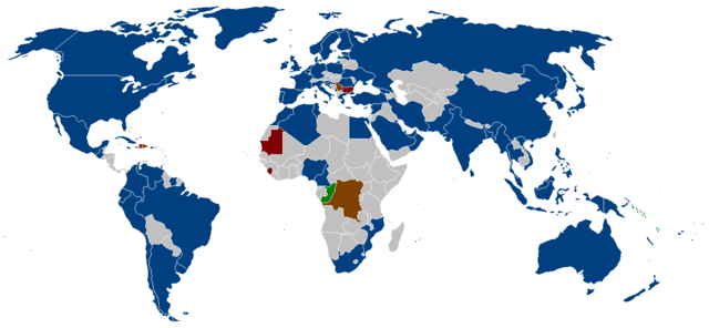
English: The member states of the International Hydrographic Organization as listed on their website.
Blue = members
Brown = suspended members
Red = approved, but awaiting deposit of Instrument of Accession
Green = membership Applications Deutsch: Die Mitgliedsstaaten der Internationalen Hydrographischen Organisation wie auf der Webseite angegeben.
Blau = Mitglieder
Braun = suspendierte Mitglieder
Rot = genehmigt, aber in Erwartung der Hinterlegung der Beitrittsurkunde
Grün = Mitgliedschaftsanträge |
| स्रोत | |
| लेखक |
परवाना:

|
फ्री सॉफ्टवेअर फाऊंडेशन द्वारे प्रकाशित जीएनयू मुक्त दस्ताऐवजीकरण परवाना, आवृत्ती १.२ किंवा त्यानंतरची,या अंतर्गत; या दस्तावेजास, नकलविण्याची, वितरणाची व/किंवा फेरबदलाची परवानगी दिल्या जाते या अटींसह कि त्यात कोणतेही निश्चलित(Invariant) विभाग नकोत,पृष्टपान मजकूर नको व मलपान मजकूर नको. GNU Free Documentation License हा मथळा असलेल्या विभागात,या परवान्याची प्रत अंतर्भूत केलेली आहे. |
| ही संचिका खालील परवान्याअंतर्गत आहे - क्रीएटिव्ह कॉमन्स Attribution-Share Alike 3.0 Unported. | ||
| ||
| GFDL चा भाग म्हणून परवाना अपडेट हि परवाना खूण या संचिकेस जोडलेली होती. (संचिका म्हणजे File) |
संचिकेचा इतिहास
संचिकेची त्यावेळची आवृत्ती बघण्यासाठी त्या दिनांक/वेळेवर टिचकी द्या.
| दिनांक/वेळ | छोटे चित्र | आकार | सदस्य | प्रतिक्रीया | |
|---|---|---|---|---|---|
| सद्य | ०३:०१, ९ सप्टेंबर २०१५ | | १,३५० × ६२५ (३७ कि.बा.) | Zntrip | Updated |
| १८:१७, ९ जुलै २०११ |  | १,३५० × ६२५ (५३ कि.बा.) | Maphobbyist | South Sudan has become independent on July 9, 2011. Sudan and South Sudan are shown with the new international border between them. | |
| १५:५८, २२ सप्टेंबर २००८ |  | १,३५० × ६२५ (३० कि.बा.) | Jackaranga | update | |
| १५:५४, २२ सप्टेंबर २००८ |  | १,३५० × ६२५ (३० कि.बा.) | Jackaranga | update | |
| ०८:४७, ६ जून २००६ |  | १,३५० × ६२५ (५४ कि.बा.) | Zntrip | Added Montenegro | |
| ०८:१४, १६ मे २००६ |  | १,३५० × ६२५ (५४ कि.बा.) | Zntrip | added more stiff | |
| ०८:०९, १६ मे २००६ |  | १,३५० × ६२५ (५४ कि.बा.) | Zntrip | Updated | |
| १७:५५, २८ एप्रिल २००६ |  | १,३५७ × ६२८ (५३ कि.बा.) | Roke~commonswiki | forgot china | |
| १७:५३, २८ एप्रिल २००६ |  | १,३५७ × ६२८ (५३ कि.बा.) | Roke~commonswiki | member states of the w:International Hydrographic Organization as listed on their [http://www.iho.shom.fr/ website] *yellow= members *orange = suspended members (note there is a mistake in their map - which shows the republic of Congo, instead of t |
दुवे
खालील पाने या संचिकेला जोडली आहेत:
जागतिक संचिका उपयोग
संचिकाचे इतर विकिपीडियावरील वापरः
- an.wikipedia.org वरील उपयोग
- ar.wikipedia.org वरील उपयोग
- ast.wikipedia.org वरील उपयोग
- ca.wikipedia.org वरील उपयोग
- de.wikipedia.org वरील उपयोग
- en.wikipedia.org वरील उपयोग
- eo.wikipedia.org वरील उपयोग
- es.wikipedia.org वरील उपयोग
- fy.wikipedia.org वरील उपयोग
- gl.wikipedia.org वरील उपयोग
- he.wikipedia.org वरील उपयोग
- it.wikipedia.org वरील उपयोग
- ja.wikipedia.org वरील उपयोग
- ko.wikipedia.org वरील उपयोग
- ms.wikipedia.org वरील उपयोग
- nl.wikipedia.org वरील उपयोग
- pl.wikipedia.org वरील उपयोग
- pt.wikipedia.org वरील उपयोग
- sw.wikipedia.org वरील उपयोग
- vi.wikipedia.org वरील उपयोग
- zh.wikipedia.org वरील उपयोग