
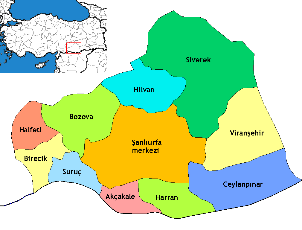
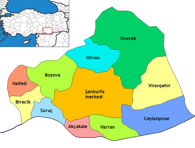
चित्र:Şanlıurfa districts.png
या झलकेचा आकार: ७८८ × ६०० पिक्सेल पिक्सेल. इतर resolutions: ३१५ × २४० पिक्सेल | ६३१ × ४८० पिक्सेल | १,०१० × ७६९ पिक्सेल.
मूळ संचिका (१,०१० × ७६९ पिक्सेल, संचिकेचा आकार: २७ कि.बा., MIME प्रकार: image/png)

|
This locator map image could be re-created using vector graphics as an SVG file. This has several advantages; see Commons:Media for cleanup for more information. If an SVG form of this image is available, please upload it and afterwards replace this template with
{{vector version available|new image name}}.
It is recommended to name the SVG file “Şanlıurfa districts.svg”—then the template Vector version available (or Vva) does not need the new image name parameter. |
सारांश
Map of the districts of Şanlıurfa province in Turkey. Created by Rarelibra 17:13, 4 December 2006 (UTC) for public domain use, using MapInfo Professional v8.5 and various mapping resources. Edited by One Homo Sapiens Corrected text where İ,Ş,ı,ğ,or ş occurs in name. Source: [statoids-com]. Increased font size and enhanced color differences among adjacent districts.
परवाना:
I, the copyright holder of this work, hereby publish it under the following license:
ही संचिका खालील परवान्याअंतर्गत आहे - क्रीएटिव्ह कॉमन्स Attribution-Share Alike 2.5 Generic.
- तुम्ही मुक्त आहात.
- सामायिक करा – नक्कल, वितरण आणि पारेषित करण्यास
- पुर्नमिश्रीत करण्यास – काम गरजेनुसार अनुकुलीत करण्यास
- खालील अटींच्या अधिन राहून:
- रोपण – आपण योग्य क्रेडिट देणे आवश्यक आहे, परवान्यास दुवा प्रदान करणे आवश्यक आहे, आणि बदल केले गेले आहेत हे दर्शविणे आवश्यक आहे. आपण हे कोणत्याही वाजवी मार्गाने करू शकता, परंतु परवानाधारक आपल्यास किंवा आपल्या वापरास मान्यता देतो अशा कोणत्याही मार्गाने नाही.
- जसेहोते-वाटातसेच (शेअर अलाईक) – जर तुम्ही या कामात काही बदल केलात, काटछाट केलीत, किंवा भर घातली, तर असे करून बनलेले नवीन काम तुम्ही केवळ या किंवा यासारख्याच परवान्याअंतर्गत प्रसारित करू शकतात.
संचिकेचा इतिहास
संचिकेची त्यावेळची आवृत्ती बघण्यासाठी त्या दिनांक/वेळेवर टिचकी द्या.
| दिनांक/वेळ | छोटे चित्र | आकार | सदस्य | प्रतिक्रीया | |
|---|---|---|---|---|---|
| सद्य | ०६:४९, ६ नोव्हेंबर २००९ | | १,०१० × ७६९ (२७ कि.बा.) | ZooFari | Trimmed |
| ०७:५९, २९ डिसेंबर २००८ |  | १,०५६ × ८१६ (२८ कि.बा.) | One Homo Sapiens | Corrected text where İ,Ş,ı,ğ,or ş occurs in name. Source: [statoids-com]. Increased font size and enhanced color differences among adjacent districts. | |
| ०३:३३, १६ एप्रिल २००७ |  | १,०५६ × ८१६ (३३ कि.बा.) | Denizz~commonswiki | == Summary == Map of the districts of Şanlıurfa province in Turkey. Created by Rarelibra 17:13, 4 December 2006 (UTC) for public domain use, using MapInfo Professional v8.5 and various mapping resources. == Licensing == {{self|cc-by-s |
दुवे
खालील पाने या संचिकेला जोडली आहेत:
जागतिक संचिका उपयोग
संचिकाचे इतर विकिपीडियावरील वापरः
- ar.wikipedia.org वरील उपयोग
- ast.wikipedia.org वरील उपयोग
- avk.wikipedia.org वरील उपयोग
- ca.wikipedia.org वरील उपयोग
- diq.wikipedia.org वरील उपयोग
- Qori
- Babıci
- Şablon:Karber Sêwrege
- Şablon:Karber Rıha
- Alan, Sêwrege
- Alanqoz
- Anazo
- Arastul
- Axsun
- Bab
- Babvêren
- Bahser
- Sahrık
- İniyoderg
- Tıl
- Xırabrês
- Hop, Sêwrege
- Modan, Sêwrege
- Mextele
- Qetine
- Hadro
- Kelosk
- Kolik
- Baxce
- Benek
- Bexdes
- Bideri
- Boxcık
- Bitik
- Buxdikan
- Catax
- Celkani
- Celtug
- Dewık (Sêwrege)
- Alangoza Cêri
- Cepni
- Cımo qelısi
- Daragon
- Dinar (dewe)
- Gerisar
- Bılerız
- Qışlan
- Herheri
- Xalokend
- Salıcan
- Xarzeno
या संचिकेचे अधिक वैश्विक उपयोग पहा