
चित्र:Map of Ohio NA.png

या झलकेचा आकार: ८०० × ५४२ पिक्सेल पिक्सेल. इतर resolutions: ३२० × २१७ पिक्सेल | ६४० × ४३४ पिक्सेल | १,०२४ × ६९४ पिक्सेल | १,२८० × ८६७ पिक्सेल | १,९६७ × १,३३३ पिक्सेल.
मूळ संचिका (१,९६७ × १,३३३ पिक्सेल, संचिकेचा आकार: २.०२ मे.बा., MIME प्रकार: image/png)
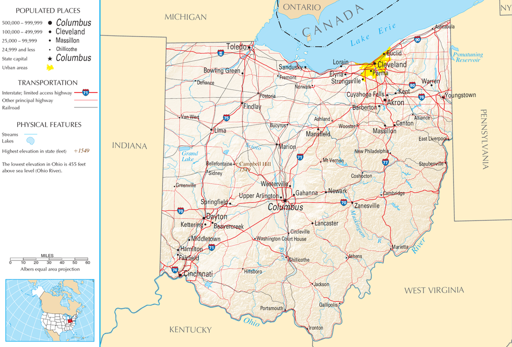
| वर्णन | Map of Ohio |
| स्रोत | National Atlas |
| लेखक |
This map was obtained from an edition of the National Atlas of the United States. Like almost all works of the U.S. federal government, works from the National Atlas are in the public domain in the United States.
Online access: NationalAtlas.gov | 1970 print edition: Library of Congress, Perry-Castañeda Library
|
संचिकेचा इतिहास
संचिकेची त्यावेळची आवृत्ती बघण्यासाठी त्या दिनांक/वेळेवर टिचकी द्या.
| दिनांक/वेळ | छोटे चित्र | आकार | सदस्य | प्रतिक्रीया | |
|---|---|---|---|---|---|
| सद्य | १६:५१, ३० ऑगस्ट २००७ | | १,९६७ × १,३३३ (२.०२ मे.बा.) | Conscious | cropped |
| १३:३२, १५ ऑगस्ट २००६ |  | २,१२२ × १,६४० (२.१७ मे.बा.) | Huebi~commonswiki | {{Information| |Description=Map of Ohio |Source=[http://www.nationalatlas.gov National Atlas] }} Category:Maps of the United States Category:Maps of Ohio {{PD-USGov-Atlas}} |
दुवे
खालील पाने या संचिकेला जोडली आहेत:
जागतिक संचिका उपयोग
संचिकाचे इतर विकिपीडियावरील वापरः
- arz.wikipedia.org वरील उपयोग
- de.wikipedia.org वरील उपयोग
- en.wikipedia.org वरील उपयोग
- es.wikipedia.org वरील उपयोग
- eu.wikipedia.org वरील उपयोग
- fr.wikipedia.org वरील उपयोग
- gl.wikipedia.org वरील उपयोग
- hr.wiktionary.org वरील उपयोग
- hsb.wikipedia.org वरील उपयोग
- hu.wikipedia.org वरील उपयोग
- incubator.wikimedia.org वरील उपयोग
- io.wikipedia.org वरील उपयोग
- it.wikipedia.org वरील उपयोग
- ja.wikipedia.org वरील उपयोग
- kk.wikipedia.org वरील उपयोग
- mk.wikipedia.org वरील उपयोग
- nl.wikipedia.org वरील उपयोग
- rue.wikipedia.org वरील उपयोग
- ru.wikipedia.org वरील उपयोग
- stq.wikipedia.org वरील उपयोग
- sw.wikipedia.org वरील उपयोग
- szl.wikipedia.org वरील उपयोग
- zea.wikipedia.org वरील उपयोग