
चित्र:Yugoslavia 1956-1990.svg

Size of this PNG preview of this SVG file: ४५० × ४५६ पिक्सेल. इतर resolutions: २३७ × २४० पिक्सेल | ४७४ × ४८० पिक्सेल | ७५८ × ७६८ पिक्सेल | १,०११ × १,०२४ पिक्सेल | २,०२१ × २,०४८ पिक्सेल.
मूळ संचिका (SVG संचिका, साधारणपणे ४५० × ४५६ pixels, संचिकेचा आकार: ४७५ कि.बा.)
सारांश


.svg)
.svg)
.svg)
.svg)
.svg)


.svg)
.svg)
.svg)


.png)
.png)


.svg)


.svg)

.svg)


.svg)
.svg)
.svg)
.svg)


.svg)
.png)


.svg)


.svg)
.svg)


.svg)


.svg)


.svg)
.svg)
.svg)
.svg)
.svg)
.svg)
.svg)
_cropped.svg)
.svg)
.svg)
.svg)
.svg)
.svg)
.svg)
.svg)
.svg)
.svg)
.svg)
.svg)
.svg)
.svg)
.svg)
.svg)
.svg)
.svg)
.svg)
.svg)
.svg)
.svg)
.svg)
.svg)
.svg)
.svg)
.svg)
.svg)
.svg)
.svg)
.svg)
.svg)
.svg)
.svg)
.svg)
.svg)
.svg)
.svg)
.svg)
.svg)
.svg)
.svg)
.svg)
.svg)
.svg)
.svg)
| This is a retouched picture, which means that it has been digitally altered from its original version. The original can be viewed here: Blank map of Europe 1956-1990.svg:
|
परवाना:
I, the copyright holder of this work, hereby publish it under the following license:
ही संचिका खालील परवान्याअंतर्गत आहे - क्रीएटिव्ह कॉमन्स Attribution-Share Alike 3.0 Unported.
- तुम्ही मुक्त आहात.
- सामायिक करा – नक्कल, वितरण आणि पारेषित करण्यास
- पुर्नमिश्रीत करण्यास – काम गरजेनुसार अनुकुलीत करण्यास
- खालील अटींच्या अधिन राहून:
- रोपण – आपण योग्य क्रेडिट देणे आवश्यक आहे, परवान्यास दुवा प्रदान करणे आवश्यक आहे, आणि बदल केले गेले आहेत हे दर्शविणे आवश्यक आहे. आपण हे कोणत्याही वाजवी मार्गाने करू शकता, परंतु परवानाधारक आपल्यास किंवा आपल्या वापरास मान्यता देतो अशा कोणत्याही मार्गाने नाही.
- जसेहोते-वाटातसेच (शेअर अलाईक) – जर तुम्ही या कामात काही बदल केलात, काटछाट केलीत, किंवा भर घातली, तर असे करून बनलेले नवीन काम तुम्ही केवळ या किंवा यासारख्याच परवान्याअंतर्गत प्रसारित करू शकतात.
चढवल्याचे मुळ विवरण
This image is a derivative work of the following images:
- File:Blank_map_of_Europe_1956-1990.svg licensed with Cc-by-sa-3.0
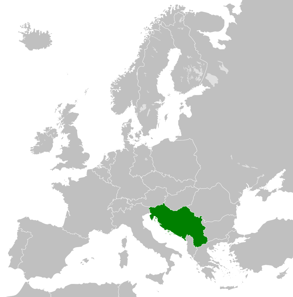
- 2011-10-30T04:43:42Z Alphathon 450x456 (485146 Bytes) == {{int:filedesc}} == {{Information |Description={{en|Blank map of Europe showing national borders as they stood from 1956-1990.}} |Source=*[[:File:Blank_map_of_Europe.svg|]] |Date=2011-10-30 04:42 (UTC) |Author=*[[:File:Bla
| Annotations | This image is annotated: View the annotations at Commons |
संचिकेचा इतिहास
संचिकेची त्यावेळची आवृत्ती बघण्यासाठी त्या दिनांक/वेळेवर टिचकी द्या.
| दिनांक/वेळ | छोटे चित्र | आकार | सदस्य | प्रतिक्रीया | |
|---|---|---|---|---|---|
| सद्य | ०६:३०, २६ नोव्हेंबर २०११ | | ४५० × ४५६ (४७५ कि.बा.) | StalwartUK | == {{int:filedesc}} == {{Information |Description={{en|Map of Socialist Federal Republic of Yugoslavia as it was from 1945-1992. Surrounding countries accurate from 1956-1990.}} |Source=*[[:File:Blank_map_o |
दुवे
खालील पाने या संचिकेला जोडली आहेत:
जागतिक संचिका उपयोग
संचिकाचे इतर विकिपीडियावरील वापरः
- ar.wikipedia.org वरील उपयोग
- arz.wikipedia.org वरील उपयोग
- ast.wikipedia.org वरील उपयोग
- ast.wiktionary.org वरील उपयोग
- azb.wikipedia.org वरील उपयोग
- az.wikipedia.org वरील उपयोग
- az.wiktionary.org वरील उपयोग
- be-tarask.wikipedia.org वरील उपयोग
- be.wikipedia.org वरील उपयोग
- bg.wikipedia.org वरील उपयोग
- bs.wikipedia.org वरील उपयोग
- ca.wikipedia.org वरील उपयोग
- ce.wikipedia.org वरील उपयोग
- cs.wikipedia.org वरील उपयोग
- da.wikipedia.org वरील उपयोग
- de.wikipedia.org वरील उपयोग
- en.wikipedia.org वरील उपयोग
- Socialist Federal Republic of Yugoslavia
- User:Mr Hall of England/sandbox
- Telephone numbers in Yugoslavia
- User:Falcaorib
- Soviet involvement in regime change
- User:XP6287/sandbox
- Guyana–Yugoslavia relations
- Cyprus–Yugoslavia relations
- Afghanistan–Yugoslavia relations
- Pakistan–Yugoslavia relations
- Canada–Yugoslavia relations
- Malta–Yugoslavia relations
- Germany–Yugoslavia relations
- Nicaragua–Yugoslavia relations
- Brazil–Yugoslavia relations
- Cambodia–Yugoslavia relations
- List of companies of the Socialist Federal Republic of Yugoslavia
- en.wiktionary.org वरील उपयोग
- es.wikipedia.org वरील उपयोग
- es.wiktionary.org वरील उपयोग
- eu.wikipedia.org वरील उपयोग
- fa.wikipedia.org वरील उपयोग
- fi.wikipedia.org वरील उपयोग
- fo.wikipedia.org वरील उपयोग
- frr.wikipedia.org वरील उपयोग
- fr.wikipedia.org वरील उपयोग
या संचिकेचे अधिक वैश्विक उपयोग पहा