
चित्र:Tu-map.png
यापेक्षा मोठे चित्र उपलब्ध नाही.
Tu-map.png (६३१ × ३२१ पिक्सेल, संचिकेचा आकार: २३ कि.बा., MIME प्रकार: image/png)
From en.wikipedia
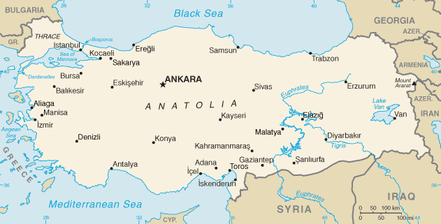
map of Turkey, converted directly from CIA World Factbook GIF
This image is in the public domain because it contains materials that originally came from the United States Central Intelligence Agency's World Factbook.
|
 |
derivative works
Derivative works of this file: Tu-map-ar.png
संचिकेचा इतिहास
संचिकेची त्यावेळची आवृत्ती बघण्यासाठी त्या दिनांक/वेळेवर टिचकी द्या.
| दिनांक/वेळ | छोटे चित्र | आकार | सदस्य | प्रतिक्रीया | |
|---|---|---|---|---|---|
| सद्य | १३:०५, १९ फेब्रुवारी २०२२ | | ६३१ × ३२१ (२३ कि.बा.) | Lojwe | Cropped < 1 % horizontally, 1 % vertically using CropTool with precise mode. |
| ०६:५५, १३ सप्टेंबर २०१२ |  | ६३४ × ३२४ (४१ कि.बा.) | Thricecube | Updated map | |
| १३:०१, २७ सप्टेंबर २००५ |  | ७३७ × ३७५ (१९२ कि.बा.) | Kgyt | From en.wikipedia map of Turkey, converted directly from CIA World Factbook GIF {{PD-USGov-CIA-WF}} | |
| ०१:१९, ७ जानेवारी २००५ |  | ६३४ × ३२४ (१९ कि.बा.) | Lukius~commonswiki | From en.wikipedia |
दुवे
खालील पाने या संचिकेला जोडली आहेत:
जागतिक संचिका उपयोग
संचिकाचे इतर विकिपीडियावरील वापरः
- az.wikipedia.org वरील उपयोग
- be-tarask.wikipedia.org वरील उपयोग
- bh.wikipedia.org वरील उपयोग
- bn.wikipedia.org वरील उपयोग
- bxr.wikipedia.org वरील उपयोग
- ckb.wikipedia.org वरील उपयोग
- da.wikipedia.org वरील उपयोग
- dsb.wikipedia.org वरील उपयोग
- en.wikipedia.org वरील उपयोग
- en.wikivoyage.org वरील उपयोग
- eo.wikipedia.org वरील उपयोग
- es.wikipedia.org वरील उपयोग
- gag.wikipedia.org वरील उपयोग
- gl.wikipedia.org वरील उपयोग
- hi.wikipedia.org वरील उपयोग
- hu.wikipedia.org वरील उपयोग
- id.wikipedia.org वरील उपयोग
- incubator.wikimedia.org वरील उपयोग
- io.wikipedia.org वरील उपयोग
- is.wikipedia.org वरील उपयोग
- it.wikipedia.org वरील उपयोग
- it.wikinews.org वरील उपयोग
- ja.wikipedia.org वरील उपयोग
- jv.wikipedia.org वरील उपयोग
- ko.wikipedia.org वरील उपयोग
- lfn.wikipedia.org वरील उपयोग
या संचिकेचे अधिक वैश्विक उपयोग पहा