
चित्र:Tokara-eilanden.png
यापेक्षा मोठे चित्र उपलब्ध नाही.
Tokara-eilanden.png (४१९ × १७५ पिक्सेल, संचिकेचा आकार: ४ कि.बा., MIME प्रकार: image/png)
सारांश
| वर्णन |
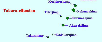
English: Map of the Tokara Islands, Kagoshima Prefecture, Japan |
||
| दिनांक | (UTC) | ||
| स्रोत | |||
| लेखक |
|
||
| इतर आवृत्तींस |
|

| This is a retouched picture, which means that it has been digitally altered from its original version. The original can be viewed here: Satsunan Islands.png:
|
परवाना:
I, the copyright holder of this work, hereby publish it under the following license:
| I, the copyright holder of this work, release this work into the public domain. This applies worldwide. असे करणे काही देशांमधे कायद्यानुसार शक्य नसू शकते. असे असल्यास : मी कोणालाही कोणत्याही कारणासाठी हे काम वापरण्याचे अधिकार कोणत्याही बंधनाशिवाय जर अशी बंधने कायद्याने बंधनकारक नसतीलतर देत आहोत. |
चढवल्याचे मुळ विवरण
This image is a derivative work of the following images:
- File:Satsunan_Islands.png licensed with PD-self
- 2007-01-05T16:16:30Z Krisgrotius 780x1083 (77720 Bytes) {{Information |Description=Map of the Satsunan Islands (Ōsumi Islands + Tokara Islands + Amami Islands), Ryukyu , Japan |Source= own work |Date=~~~~~ |Author=~~~ |Permission= |other_versions= public }}
Uploaded with derivativeFX
संचिकेचा इतिहास
संचिकेची त्यावेळची आवृत्ती बघण्यासाठी त्या दिनांक/वेळेवर टिचकी द्या.
| दिनांक/वेळ | छोटे चित्र | आकार | सदस्य | प्रतिक्रीया | |
|---|---|---|---|---|---|
| सद्य | ००:२५, २ मार्च २००९ | | ४१९ × १७५ (४ कि.बा.) | A1000 | {{Information |Description=Map of the Satsunan Islands (Ōsumi Islands + Tokara Islands + Amami Islands), Ryukyu , Japan |Source=*File:Satsunan_Islands.png |Date=2009-03-01 18:54 (UTC) |Author=*File:Satsunan_Islands.png: [[User:Krisgrotius|Kri |
दुवे
खालील पाने या संचिकेला जोडली आहेत:
जागतिक संचिका उपयोग
संचिकाचे इतर विकिपीडियावरील वापरः
- arz.wikipedia.org वरील उपयोग
- cs.wikipedia.org वरील उपयोग
- de.wikipedia.org वरील उपयोग
- en.wikipedia.org वरील उपयोग
- es.wikipedia.org वरील उपयोग
- fr.wikipedia.org वरील उपयोग
- ml.wikipedia.org वरील उपयोग
- no.wikipedia.org वरील उपयोग
- pl.wikipedia.org वरील उपयोग
- uk.wikipedia.org वरील उपयोग
- www.wikidata.org वरील उपयोग
- zh-min-nan.wikipedia.org वरील उपयोग
- zh-yue.wikipedia.org वरील उपयोग
- zh.wikipedia.org वरील उपयोग