
चित्र:Solapur district tehsils.svg

Size of this PNG preview of this SVG file: ७२८ × ६०० पिक्सेल. इतर resolutions: २९२ × २४० पिक्सेल | ५८३ × ४८० पिक्सेल | ९३३ × ७६८ पिक्सेल | १,२४४ × १,०२४ पिक्सेल | २,४८७ × २,०४८ पिक्सेल | ८५० × ७०० पिक्सेल.
मूळ संचिका (SVG संचिका, साधारणपणे ८५० × ७०० pixels, संचिकेचा आकार: १२४ कि.बा.)
| वर्णन |
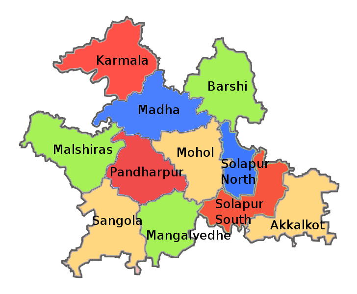
English: Tehsil map of Solapur district in the Indian state of Maharashtra. Created using this official map on Solapur district website: http://solapur.gov.in/map/smap6.html |
| दिनांक | |
| स्रोत | |
| लेखक |
|
| इतर आवृत्तींस | Derivative works of this file: Solapur district tehsils Marathi.png |
| This is a retouched picture, which means that it has been digitally altered from its original version. The original can be viewed here: Solapur district blank map.svg:
|
I, the copyright holder of this work, hereby publish it under the following license:
ही संचिका खालील परवान्याअंतर्गत आहे - क्रीएटिव्ह कॉमन्स Attribution-Share Alike 3.0 Unported.
- तुम्ही मुक्त आहात.
- सामायिक करा – नक्कल, वितरण आणि पारेषित करण्यास
- पुर्नमिश्रीत करण्यास – काम गरजेनुसार अनुकुलीत करण्यास
- खालील अटींच्या अधिन राहून:
- रोपण – आपण योग्य क्रेडिट देणे आवश्यक आहे, परवान्यास दुवा प्रदान करणे आवश्यक आहे, आणि बदल केले गेले आहेत हे दर्शविणे आवश्यक आहे. आपण हे कोणत्याही वाजवी मार्गाने करू शकता, परंतु परवानाधारक आपल्यास किंवा आपल्या वापरास मान्यता देतो अशा कोणत्याही मार्गाने नाही.
- जसेहोते-वाटातसेच (शेअर अलाईक) – जर तुम्ही या कामात काही बदल केलात, काटछाट केलीत, किंवा भर घातली, तर असे करून बनलेले नवीन काम तुम्ही केवळ या किंवा यासारख्याच परवान्याअंतर्गत प्रसारित करू शकतात.
चढवल्याचे मुळ विवरण
This image is a derivative work of the following images:
- File:Solapur_district_blank_map.svg licensed with Cc-by-sa-3.0
- 2011-08-17T20:23:57Z Abhijitsathe 850x700 (34718 Bytes) '
Uploaded with derivativeFX
संचिकेचा इतिहास
संचिकेची त्यावेळची आवृत्ती बघण्यासाठी त्या दिनांक/वेळेवर टिचकी द्या.
| दिनांक/वेळ | छोटे चित्र | आकार | सदस्य | प्रतिक्रीया | |
|---|---|---|---|---|---|
| सद्य | ०२:११, १८ ऑगस्ट २०११ | | ८५० × ७०० (१२४ कि.बा.) | Abhijitsathe | {{Information |Description={{en|1=Tehsil map of Solapur district in the Indian state of Maharashtra. Created using this official map on Solapur district website: http://solapur.gov.in/map/smap6.html}} |date=2011-08-17 |Source=*[[:File:Solapur_dist |
दुवे
खालील पाने या संचिकेला जोडली आहेत:
जागतिक संचिका उपयोग
संचिकाचे इतर विकिपीडियावरील वापरः
- bn.wikipedia.org वरील उपयोग
- en.wikipedia.org वरील उपयोग
- ka.wikipedia.org वरील उपयोग
- sat.wikipedia.org वरील उपयोग
- te.wikipedia.org वरील उपयोग