
चित्र:SFO map.png
यापेक्षा मोठे चित्र उपलब्ध नाही.
SFO_map.png (४०५ × ५८३ पिक्सेल, संचिकेचा आकार: ५७ कि.बा., MIME प्रकार: image/png)
सारांश
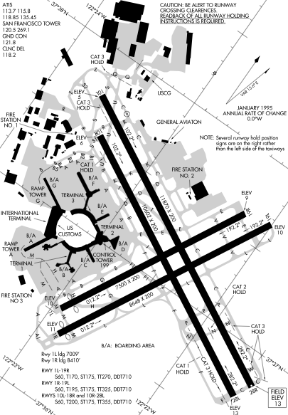
Detail from FAA diagram of San Francisco International Airport. Warning, this diagram contains material which is subject to change, do not use for navigation. There is also at least one error. The text block in the lower left gives lengths for runway "10L-18R." The runway designation should be "10L-28R."
परवाना:
This image or file is a work of a Federal Aviation Administration employee, taken or made as part of that person's official duties. As a work of the U.S. federal government, the image is in the public domain in the United States.
|
 |
संचिकेचा इतिहास
संचिकेची त्यावेळची आवृत्ती बघण्यासाठी त्या दिनांक/वेळेवर टिचकी द्या.
| दिनांक/वेळ | छोटे चित्र | आकार | सदस्य | प्रतिक्रीया | |
|---|---|---|---|---|---|
| सद्य | ०४:४४, १७ डिसेंबर २००५ | | ४०५ × ५८३ (५७ कि.बा.) | Sam916~commonswiki | ==Summary== Detail from FAA diagram of San Francisco International Airport. Warning, this diagram contains material which is subject to change, do not use for navigation. ==Licensing== {{PD-USGov-FAA}} |
दुवे
खालील पाने या संचिकेला जोडली आहेत:
जागतिक संचिका उपयोग
संचिकाचे इतर विकिपीडियावरील वापरः
- ca.wikipedia.org वरील उपयोग
- de.wikipedia.org वरील उपयोग
- fr.wikipedia.org वरील उपयोग
- he.wikipedia.org वरील उपयोग
- id.wikipedia.org वरील उपयोग
- ja.wikipedia.org वरील उपयोग
- ms.wikipedia.org वरील उपयोग
- ta.wikipedia.org वरील उपयोग
- th.wikipedia.org वरील उपयोग
- vi.wikipedia.org वरील उपयोग