
चित्र:Russia Rail Map.svg

Size of this PNG preview of this SVG file: ८०० × ४५० पिक्सेल. इतर resolutions: ३२० × १८० पिक्सेल | ६४० × ३६० पिक्सेल | १,०२४ × ५७६ पिक्सेल | १,२८० × ७२० पिक्सेल | २,५६० × १,४४० पिक्सेल | १,२९६ × ७२९ पिक्सेल.
मूळ संचिका (SVG संचिका, साधारणपणे १,२९६ × ७२९ pixels, संचिकेचा आकार: १४० कि.बा.)
सारांश
| वर्णन |
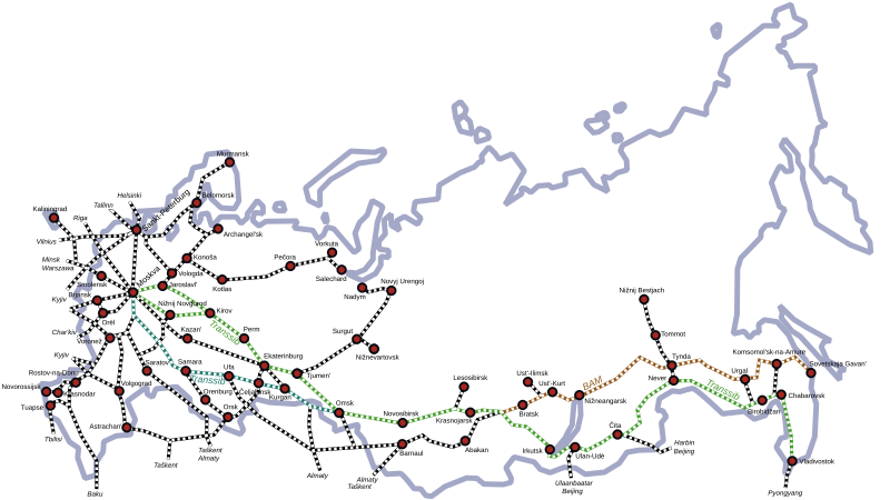
English: Russia's most important railway lines
Русский: Схема железных дорог Российской Федерации. |
| दिनांक | (UTC) |
| स्रोत | |
| लेखक |
|
| इतर आवृत्तींस |
[]
|


|
This SVG file contains embedded text that can be translated into your language, using any capable SVG editor, text editor or the SVG Translate tool. For more information see: About translating SVG files. |
| This is a retouched picture, which means that it has been digitally altered from its original version. Modifications: vector version. The original can be viewed here: Russia Rail Map.png:
|
परवाना:
I, the copyright holder of this work, hereby publish it under the following license:
| I, the copyright holder of this work, release this work into the public domain. This applies worldwide. असे करणे काही देशांमधे कायद्यानुसार शक्य नसू शकते. असे असल्यास : मी कोणालाही कोणत्याही कारणासाठी हे काम वापरण्याचे अधिकार कोणत्याही बंधनाशिवाय जर अशी बंधने कायद्याने बंधनकारक नसतीलतर देत आहोत. |
चढवल्याचे मुळ विवरण
This image is a derivative work of the following images:
- File:Russia_Rail_Map.png licensed with PD-self, PD-self/en
- 2007-09-02T21:36:21Z Voland77 1296x729 (350075 Bytes) {{Information |Description=Russia's most important railway lines |Source=own work |Date=2007-09-02 |Author=Voland77 |Permission= |other_versions= }}
Uploaded with derivativeFX
संचिकेचा इतिहास
संचिकेची त्यावेळची आवृत्ती बघण्यासाठी त्या दिनांक/वेळेवर टिचकी द्या.
| दिनांक/वेळ | छोटे चित्र | आकार | सदस्य | प्रतिक्रीया | |
|---|---|---|---|---|---|
| सद्य | १९:४६, २२ मे २०१७ | | १,२९६ × ७२९ (१४० कि.बा.) | Carfois | - Colored in emerald color the historical Transsiberian line. - Colored in green the route via Nižnij Novgorod used today by the Transsiberian trains № 002М/001М «Россия» like the other route, via Jaroslavl', used today by the other Transs... |
| १६:०३, २१ मे २०१७ |  | १,२९६ × ७२९ (१३८ कि.बा.) | Carfois | - Added Ufa, Perm, Krasnodar - Corrected Birobidžan position - Added layers in the file (please don't remove them) | |
| १९:०५, १९ डिसेंबर २०११ |  | १,२९६ × ७२९ (१३९ कि.बा.) | Insider | fix Belomorsk and Oboserskaya-Belomorsk railway | |
| ०३:४२, ११ फेब्रुवारी २००९ |  | १,२९६ × ७२९ (१३४ कि.बा.) | Voland77 | {{Information |Description=Russia's most important railway lines |Source=*File:Russia_Rail_Map.png |Date=2009-02-10 22:12 (UTC) |Author=*File:Russia_Rail_Map.png: Voland77 *derivative work: ~~~ |Permission=see below |other_versions= }} {{Reto |
दुवे
खालील पाने या संचिकेला जोडली आहेत:
जागतिक संचिका उपयोग
संचिकाचे इतर विकिपीडियावरील वापरः
- ab.wikipedia.org वरील उपयोग
- ast.wikipedia.org वरील उपयोग
- bg.wikipedia.org वरील उपयोग
- da.wikipedia.org वरील उपयोग
- de.wikipedia.org वरील उपयोग
- en.wikipedia.org वरील उपयोग
- es.wikipedia.org वरील उपयोग
- fa.wikipedia.org वरील उपयोग
- fr.wikipedia.org वरील उपयोग
- he.wikipedia.org वरील उपयोग
- he.wikivoyage.org वरील उपयोग
- hu.wikipedia.org वरील उपयोग
- id.wikipedia.org वरील उपयोग
- ja.wikipedia.org वरील उपयोग
- no.wikipedia.org वरील उपयोग
- ro.wikipedia.org वरील उपयोग
- ru.wikipedia.org वरील उपयोग
- simple.wikipedia.org वरील उपयोग
- sv.wikipedia.org वरील उपयोग
- th.wikipedia.org वरील उपयोग
- uk.wikipedia.org वरील उपयोग
- zh.wikipedia.org वरील उपयोग