
चित्र:Pakistan population density.png
या झलकेचा आकार: ६४० × ५९९ पिक्सेल पिक्सेल. इतर resolutions: २५६ × २४० पिक्सेल | ८२० × ७६८ पिक्सेल | १,०९४ × १,०२४ पिक्सेल | २,१८७ × २,०४८ पिक्सेल | ५,४०० × ५,०५६ पिक्सेल.
मूळ संचिका (५,४०० × ५,०५६ पिक्सेल, संचिकेचा आकार: १.८८ मे.बा., MIME प्रकार: image/png)

|
This file has been superseded by Population Density by Pakistani District - 2017 Census.SVG. It is recommended to use the other file. Please note that deleting superseded images requires consent. Reason to use the other file: "SVG File that uses a better template, is more detailed, and fixes many errors"
|
new file |
सारांश
| वर्णन |
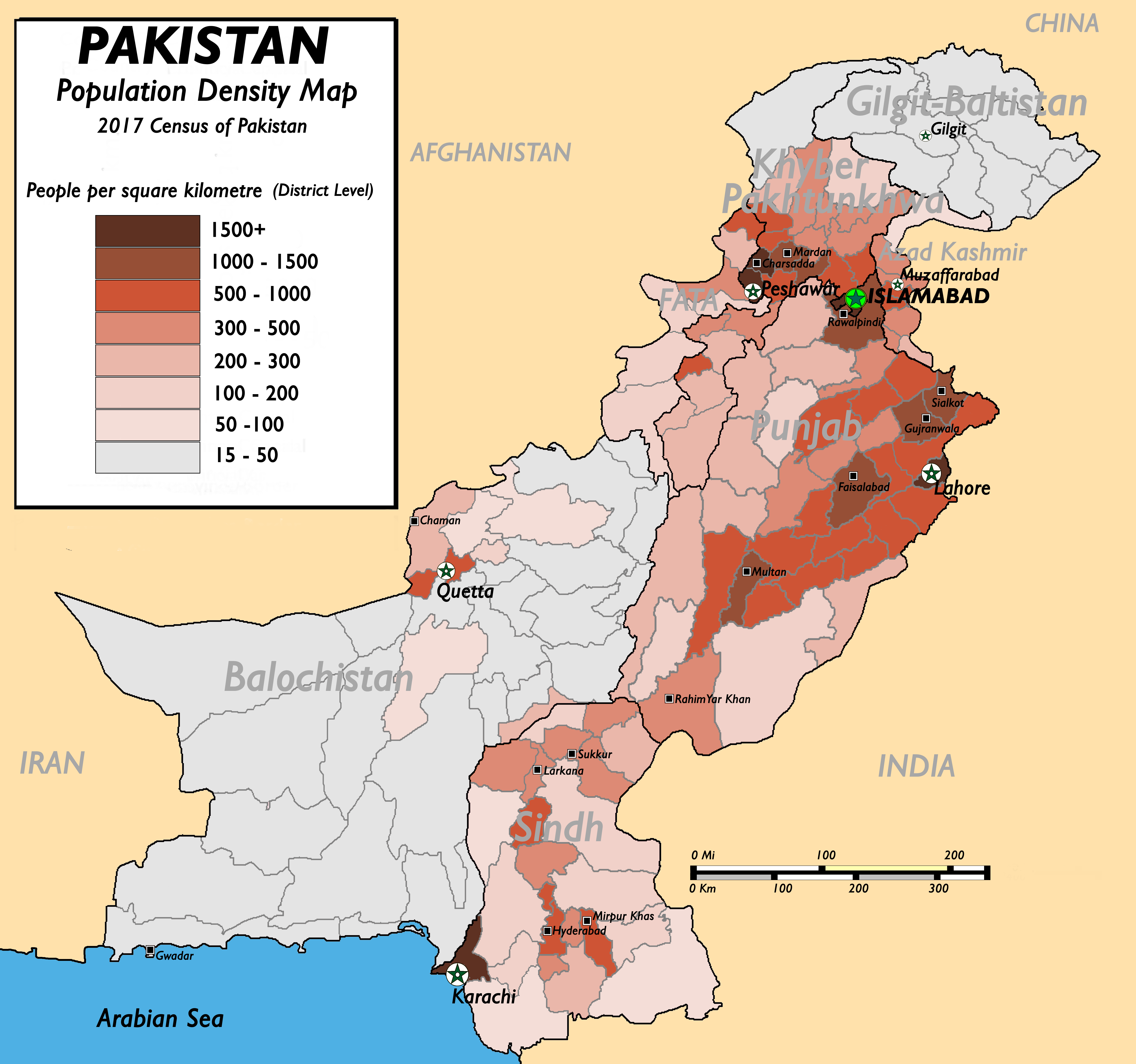
English: Pakistan Population Density Map (English). (Abbreviations used: 1. NWFP = North West Frontier Province, 2. FATA = Federally Administered Tribal Areas.) |
| दिनांक | ऑगस्ट १३, इ.स. २००९ (original upload date) |
| स्रोत |
(New version uploaded by using data from 2017 Pakistan Population Census, Official Website (Original text: I created this work by myself with the sources of World Trade Press and Population census organisation, Government of Pakistan.) |
| लेखक | nomi887 (talk) |
परवाना:
Nomi887 at इंग्रजी विकिपीडिया, या कामाच्या प्रताधिकार असलेली व्यक्ती , याद्वारे खालील परवान्यांच्या अधिन राहून प्रसिद्ध करीत आहे:
ही संचिका खालील परवान्याअंतर्गत आहे - क्रीएटिव्ह कॉमन्स Attribution-Share Alike 3.0 Unported.
रोपण: Nomi887 at इंग्रजी विकिपीडिया
- तुम्ही मुक्त आहात.
- सामायिक करा – नक्कल, वितरण आणि पारेषित करण्यास
- पुर्नमिश्रीत करण्यास – काम गरजेनुसार अनुकुलीत करण्यास
- खालील अटींच्या अधिन राहून:
- रोपण – आपण योग्य क्रेडिट देणे आवश्यक आहे, परवान्यास दुवा प्रदान करणे आवश्यक आहे, आणि बदल केले गेले आहेत हे दर्शविणे आवश्यक आहे. आपण हे कोणत्याही वाजवी मार्गाने करू शकता, परंतु परवानाधारक आपल्यास किंवा आपल्या वापरास मान्यता देतो अशा कोणत्याही मार्गाने नाही.
- जसेहोते-वाटातसेच (शेअर अलाईक) – जर तुम्ही या कामात काही बदल केलात, काटछाट केलीत, किंवा भर घातली, तर असे करून बनलेले नवीन काम तुम्ही केवळ या किंवा यासारख्याच परवान्याअंतर्गत प्रसारित करू शकतात.

|
फ्री सॉफ्टवेअर फाऊंडेशन द्वारे प्रकाशित जीएनयू मुक्त दस्ताऐवजीकरण परवाना, आवृत्ती १.२ किंवा त्यानंतरची,या अंतर्गत; या दस्तावेजास, नकलविण्याची, वितरणाची व/किंवा फेरबदलाची परवानगी दिल्या जाते या अटींसह कि त्यात कोणतेही निश्चलित(Invariant) विभाग नकोत,पृष्टपान मजकूर नको व मलपान मजकूर नको. GNU Free Documentation License हा मथळा असलेल्या विभागात,या परवान्याची प्रत अंतर्भूत केलेली आहे. |
तुमच्या पसंतीचा परवाना तुम्ही निवडू शकता.
चढवल्याचे मुळ विवरण
The original description page was here. All following user names refer to en.wikipedia.
- 2009-08-13 11:22 Brainlara73 1357×1348× (210478 bytes) Reverted to version as of 11:06, 13 August 2009
- 2009-08-13 11:07 Brainlara73 1357×1348× (210478 bytes) location corrected
- 2009-08-13 11:06 Brainlara73 1357×1348× (210478 bytes) location corrected
- 2009-08-13 09:57 Nomi887 1357×1348× (235717 bytes) More scrutinized version.
- 2009-07-07 11:18 Brainlara73 1361×1390× (195660 bytes) Added Jhelum in Punjab
- 2009-06-11 09:46 Nomi887 1361×1390× (212195 bytes) {{Information |Description = Pakistan Population Density Map (English). |Source = I created this work by myself with the sources of [http://www.bestcountryreports.com/Population_Map_Pakistan.html World Trade Press] and [http://www.statpak.gov
संचिकेचा इतिहास
संचिकेची त्यावेळची आवृत्ती बघण्यासाठी त्या दिनांक/वेळेवर टिचकी द्या.
| दिनांक/वेळ | छोटे चित्र | आकार | सदस्य | प्रतिक्रीया | |
|---|---|---|---|---|---|
| सद्य | १८:१३, १७ डिसेंबर २०१८ | | ५,४०० × ५,०५६ (१.८८ मे.बा.) | Nomi887 | New version as per Pakistan Population Census of 2017 by using data from #REDIRECTCensus Data, Pakistan Bureau of Statistics |
| १३:२७, ११ एप्रिल २०११ |  | १,३८९ × १,३८३ (२२० कि.बा.) | Nomi887 | minor corrections in locations and density | |
| २३:०५, १८ मार्च २०१० |  | १,३५७ × १,३४८ (२०६ कि.बा.) | Ranveig | {{Information |Description={{en|Pakistan Population Density Map (English). ''(Abbreviations used: 1. NWFP = North West Frontier Province, 2. FATA = Federally Administered Tribal Areas.)''}} |Source=Transferred from [http://en.wikipedia.org en.wikipedia]<b |
दुवे
खालील पाने या संचिकेला जोडली आहेत:
जागतिक संचिका उपयोग
संचिकाचे इतर विकिपीडियावरील वापरः
- ba.wikipedia.org वरील उपयोग
- bn.wikipedia.org वरील उपयोग
- bs.wikipedia.org वरील उपयोग
- de.wikipedia.org वरील उपयोग
- diq.wikipedia.org वरील उपयोग
- en.wikipedia.org वरील उपयोग
- fr.wikipedia.org वरील उपयोग
- fr.wikinews.org वरील उपयोग
- hu.wikipedia.org वरील उपयोग
- inh.wikipedia.org वरील उपयोग
- io.wikipedia.org वरील उपयोग
- ja.wikipedia.org वरील उपयोग
- nl.wikipedia.org वरील उपयोग
- nl.wikinews.org वरील उपयोग
- nn.wikipedia.org वरील उपयोग
- no.wikipedia.org वरील उपयोग
- pnb.wikipedia.org वरील उपयोग
- pt.wikipedia.org वरील उपयोग
- ru.wikipedia.org वरील उपयोग
- th.wikipedia.org वरील उपयोग
- uk.wikipedia.org वरील उपयोग
- ur.wikipedia.org वरील उपयोग
- vi.wikipedia.org वरील उपयोग
- zh.wikipedia.org वरील उपयोग