
चित्र:Northern Mariana Islands map.gif
यापेक्षा मोठे चित्र उपलब्ध नाही.
Northern_Mariana_Islands_map.gif (३४५ × ३७१ पिक्सेल, संचिकेचा आकार: २४ कि.बा., MIME प्रकार: image/gif)
सारांश
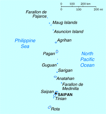
| वर्णन | Map of the Northern Mariana Islands |
| स्रोत | http://www.doi.gov/oia/Islandpages/cnmipage.htm |
| लेखक | United States Department of the Interior |
परवाना:
| This image or media file contains material based on a work of a United States Department of the Interior employee, created as part of that person's official duties. As a work of the U.S. federal government, such work is in the public domain in the United States. See the Department of the Interior copyright policy for more information. |  |
संचिकेचा इतिहास
संचिकेची त्यावेळची आवृत्ती बघण्यासाठी त्या दिनांक/वेळेवर टिचकी द्या.
| दिनांक/वेळ | छोटे चित्र | आकार | सदस्य | प्रतिक्रीया | |
|---|---|---|---|---|---|
| सद्य | ०८:४७, १८ ऑगस्ट २०१० | | ३४५ × ३७१ (२४ कि.बा.) | Ras67 | cropped |
| ०५:५४, १७ मे २००८ |  | ३५१ × ३७७ (२५ कि.बा.) | Scanlan | {{Information |Description=Map of the Northern Mariana Islands |Source=http://www.doi.gov/oia/Islandpages/cnmipage.htm |Date= |Author=United States Department of the Interior |Permission= |other_versions= }} [[Category:Maps of the Northern Marian |
दुवे
खालील पाने या संचिकेला जोडली आहेत:
जागतिक संचिका उपयोग
संचिकाचे इतर विकिपीडियावरील वापरः
- af.wikipedia.org वरील उपयोग
- ar.wikipedia.org वरील उपयोग
- ast.wikipedia.org वरील उपयोग
- be-tarask.wikipedia.org वरील उपयोग
- bn.wikipedia.org वरील उपयोग
- ch.wikipedia.org वरील उपयोग
- cs.wikipedia.org वरील उपयोग
- cy.wikipedia.org वरील उपयोग
- da.wikipedia.org वरील उपयोग
- en.wikipedia.org वरील उपयोग
- es.wikipedia.org वरील उपयोग
- fa.wikipedia.org वरील उपयोग
- fr.wikipedia.org वरील उपयोग
- he.wikipedia.org वरील उपयोग
- id.wikipedia.org वरील उपयोग
- incubator.wikimedia.org वरील उपयोग
- io.wikipedia.org वरील उपयोग
- ja.wikipedia.org वरील उपयोग
- ka.wikipedia.org वरील उपयोग
- ml.wikipedia.org वरील उपयोग
- pt.wikipedia.org वरील उपयोग
- ru.wikipedia.org वरील उपयोग
- ta.wikipedia.org वरील उपयोग
- to.wikipedia.org वरील उपयोग
- tr.wiktionary.org वरील उपयोग
- tt.wikipedia.org वरील उपयोग
- uk.wikipedia.org वरील उपयोग