
चित्र:North ossetia alania map.png

या झलकेचा आकार: ५३४ × ५९९ पिक्सेल पिक्सेल. इतर resolutions: २१४ × २४० पिक्सेल | ४२८ × ४८० पिक्सेल | ७२० × ८०८ पिक्सेल.
मूळ संचिका (७२० × ८०८ पिक्सेल, संचिकेचा आकार: ५३ कि.बा., MIME प्रकार: image/png)
सारांश
| वर्णन |
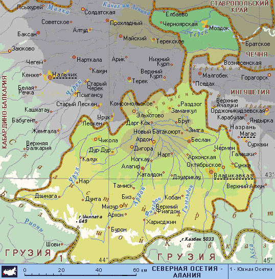
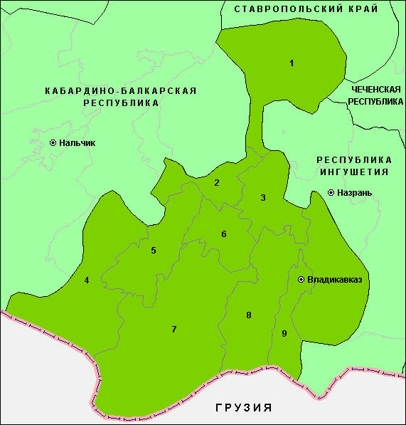
English: Map of the Republic of North Ossetia-Alania. |
| दिनांक | |
| स्रोत | स्वतःचे काम |
| लेखक | PANONIAN |
परवाना:
I, the copyright holder of this work, hereby publish it under the following license:
| This file is made available under the Creative Commons CC0 1.0 Universal Public Domain Dedication. | |
| The person who associated a work with this deed has dedicated the work to the public domain by waiving all of their rights to the work worldwide under copyright law, including all related and neighboring rights, to the extent allowed by law. You can copy, modify, distribute and perform the work, even for commercial purposes, all without asking permission.
|
References
Maps from external links:
- http://www.skppk.ru/i/map/osetiya_region_map.jpg
- http://ossetians.com/pictures/Map_1.jpg
- http://topwar.ru/uploads/posts/2011-06/1309189225_alania_karta.jpg
- http://www.stopwatchhut.com/places/770.jpg
- http://nocss.ru/projects/10/images/map-1.jpg
- http://karty.narod.ru/maps/sosetia/s-osetia.GIF
- http://obkom.com/russia/fussr/osetiya-yuzhnaya/images/karta-osetia-sev-yuzh.jpg
- http://karta-russia.ru/maps/map-severnaya-osetiya-karta.jpg
- http://alcoinf.com/images/severnaya-osetiya.gif
- http://sif.ru/images/maps/Severnaya-Osetiya2.gif
- http://region15.ru/img/territor/map-adm.gif
- http://www.hge.pu.ru/mapgis/subekt/osetia/osetia.gif
- http://www.smsr-senclub.ru/upload/medialibrary/ece/ece341c19c79030e09063fff6763d2d5.jpg
- http://www.rossadovod.ru/regions/osetia-alania/map.jpg
- http://www.ntsomz.ru/img/severnaya%20osetiya_800x566.jpg
- http://trasa.ru/img/regions/sevosetiya.gif
- http://dic.academic.ru/pictures/enc_geo/Severnaya_Osetia-Alania.jpg
- http://geo.1september.ru/2008/22/40-1.jpg
- http://openbudget.karelia.ru/budnord/russian/north-caucasian/northern-ossetiya-republic/images/karta_alania.jpg
List of largest cities and towns:
संचिकेचा इतिहास
संचिकेची त्यावेळची आवृत्ती बघण्यासाठी त्या दिनांक/वेळेवर टिचकी द्या.
| दिनांक/वेळ | छोटे चित्र | आकार | सदस्य | प्रतिक्रीया | |
|---|---|---|---|---|---|
| सद्य | १२:२१, १७ जून २०१२ | | ७२० × ८०८ (५३ कि.बा.) | PANONIAN | {{Information |Description ={{en|1=Map of the Republic of North Ossetia-Alania.}} |Source ={{own}} |Author =PANONIAN |Date =2012 |Permission = |other_versions = }} |
दुवे
खालील पाने या संचिकेला जोडली आहेत:
जागतिक संचिका उपयोग
संचिकाचे इतर विकिपीडियावरील वापरः
- ace.wikipedia.org वरील उपयोग
- ast.wikipedia.org वरील उपयोग
- az.wikipedia.org वरील उपयोग
- ba.wikipedia.org वरील उपयोग
- be-tarask.wikipedia.org वरील उपयोग
- be.wikipedia.org वरील उपयोग
- bg.wikipedia.org वरील उपयोग
- br.wikipedia.org वरील उपयोग
- bs.wikipedia.org वरील उपयोग
- bxr.wikipedia.org वरील उपयोग
- ce.wikipedia.org वरील उपयोग
- cs.wikipedia.org वरील उपयोग
- cv.wikipedia.org वरील उपयोग
- diq.wikipedia.org वरील उपयोग
- en.wikipedia.org वरील उपयोग
- es.wikipedia.org वरील उपयोग
- et.wikipedia.org वरील उपयोग
- eu.wikipedia.org वरील उपयोग
- fo.wikipedia.org वरील उपयोग
- ga.wikipedia.org वरील उपयोग
- gl.wikipedia.org वरील उपयोग
- got.wikipedia.org वरील उपयोग
- hy.wikipedia.org वरील उपयोग
- id.wikipedia.org वरील उपयोग
- is.wikipedia.org वरील उपयोग
- it.wikipedia.org वरील उपयोग
- ka.wikipedia.org वरील उपयोग
- kbd.wikipedia.org वरील उपयोग
- koi.wikipedia.org वरील उपयोग
- krc.wikipedia.org वरील उपयोग
- kv.wikipedia.org वरील उपयोग
- la.wikipedia.org वरील उपयोग
- lbe.wikipedia.org वरील उपयोग
- lmo.wikipedia.org वरील उपयोग
- lt.wikipedia.org वरील उपयोग
- mhr.wikipedia.org वरील उपयोग
- mn.wikipedia.org वरील उपयोग
- ms.wikipedia.org वरील उपयोग
- myv.wikipedia.org वरील उपयोग
- nn.wikipedia.org वरील उपयोग
- pnb.wikipedia.org वरील उपयोग
- ps.wikipedia.org वरील उपयोग
- ro.wikipedia.org वरील उपयोग
- rw.wikipedia.org वरील उपयोग
- sah.wikipedia.org वरील उपयोग
- scn.wikipedia.org वरील उपयोग
- sco.wikipedia.org वरील उपयोग
- se.wikipedia.org वरील उपयोग
- simple.wikipedia.org वरील उपयोग
या संचिकेचे अधिक वैश्विक उपयोग पहा