
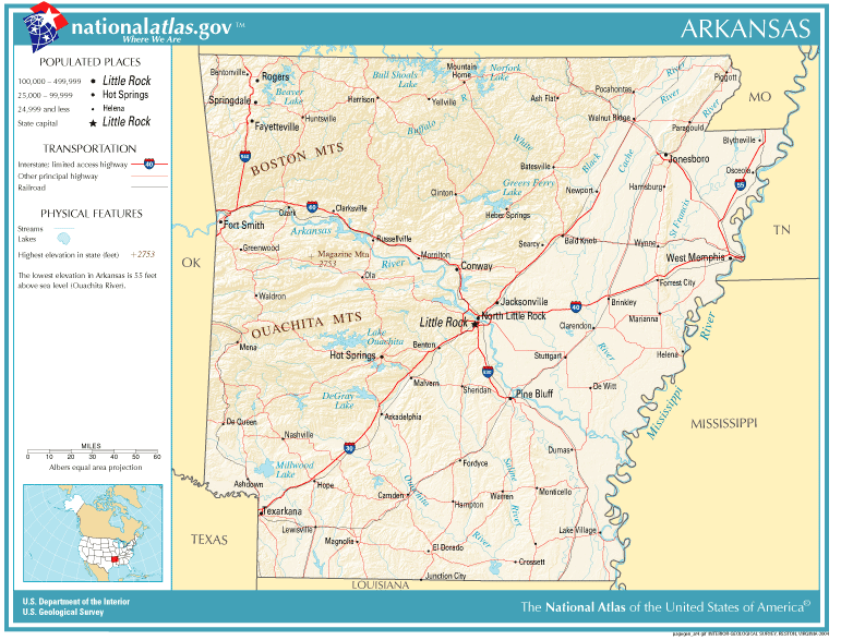
चित्र:National-atlas-arkansas.PNG
यापेक्षा मोठे चित्र उपलब्ध नाही.
National-atlas-arkansas.PNG (७७१ × ५८७ पिक्सेल, संचिकेचा आकार: १४४ कि.बा., MIME प्रकार: image/png)
सारांश
| वर्णन | |
| दिनांक | |
| स्रोत | |
| लेखक | National Atlas of the United States |
| परवानगी (या संचिकेचा पुनर्वापर करीत आहे) |
Public domain |
परवाना:
This map was obtained from an edition of the National Atlas of the United States. Like almost all works of the U.S. federal government, works from the National Atlas are in the public domain in the United States.
Online access: NationalAtlas.gov | 1970 print edition: Library of Congress, Perry-Castañeda Library
|
संचिकेचा इतिहास
संचिकेची त्यावेळची आवृत्ती बघण्यासाठी त्या दिनांक/वेळेवर टिचकी द्या.
| दिनांक/वेळ | छोटे चित्र | आकार | सदस्य | प्रतिक्रीया | |
|---|---|---|---|---|---|
| सद्य | ०४:४०, ३ जून २००६ | | ७७१ × ५८७ (१४४ कि.बा.) | Starscream | Category:Maps of Arkansas |
दुवे
खालील पाने या संचिकेला जोडली आहेत:
जागतिक संचिका उपयोग
संचिकाचे इतर विकिपीडियावरील वापरः
- en.wikipedia.org वरील उपयोग
- fr.wikipedia.org वरील उपयोग
- lt.wikipedia.org वरील उपयोग
- nl.wikipedia.org वरील उपयोग
- pl.wikipedia.org वरील उपयोग
- sq.wiktionary.org वरील उपयोग