
चित्र:Namibia map.png
यापेक्षा मोठे चित्र उपलब्ध नाही.
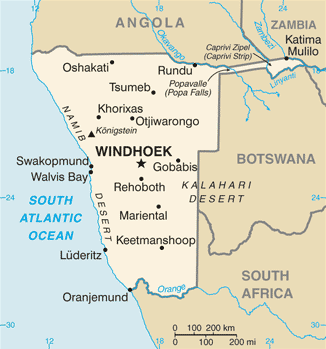
Namibia_map.png (३२६ × ३४९ पिक्सेल, संचिकेचा आकार: १९ कि.बा., MIME प्रकार: image/png)
CIA map of Namibia
- See also the 2004 version.
.png)
This image is in the public domain because it contains materials that originally came from the United States Central Intelligence Agency's World Factbook.
|
 |
derivative works
Derivative works of this file: Namibia map-sv.png
संचिकेचा इतिहास
संचिकेची त्यावेळची आवृत्ती बघण्यासाठी त्या दिनांक/वेळेवर टिचकी द्या.
| दिनांक/वेळ | छोटे चित्र | आकार | सदस्य | प्रतिक्रीया | |
|---|---|---|---|---|---|
| सद्य | १५:४७, १७ जानेवारी २०२२ | | ३२६ × ३४९ (१९ कि.बा.) | Lojwe | Cropped 1 % horizontally, 1 % vertically using CropTool with precise mode. |
| १३:२९, २१ जुलै २००७ |  | ३२८ × ३५३ (२० कि.बा.) | Hoshie | Updated map of Namibia from the CIA World Factbook, 14 June 07 rev. Src: https://www.cia.gov/library/publications/the-world-factbook/maps/wa-map.gif | |
| ०२:२१, ५ मार्च २००५ |  | ३३० × ३५५ (९ कि.बा.) | Alfio | CIA map of Namibia |
दुवे
या चित्राशी जोडलेली पृष्ठे नाहीत.
जागतिक संचिका उपयोग
संचिकाचे इतर विकिपीडियावरील वापरः
- af.wikipedia.org वरील उपयोग
- ar.wikipedia.org वरील उपयोग
- bg.wikipedia.org वरील उपयोग
- ca.wikipedia.org वरील उपयोग
- da.wikipedia.org वरील उपयोग
- de.wikipedia.org वरील उपयोग
- dsb.wikipedia.org वरील उपयोग
- en.wikipedia.org वरील उपयोग
- fi.wikipedia.org वरील उपयोग
- fr.wikipedia.org वरील उपयोग
- hif.wikipedia.org वरील उपयोग
- hr.wikipedia.org वरील उपयोग
- hu.wikipedia.org वरील उपयोग
- hu.wiktionary.org वरील उपयोग
- incubator.wikimedia.org वरील उपयोग
- it.wikipedia.org वरील उपयोग
- ja.wikipedia.org वरील उपयोग
- ka.wikipedia.org वरील उपयोग
- kg.wikipedia.org वरील उपयोग
- kn.wikipedia.org वरील उपयोग
या संचिकेचे अधिक वैश्विक उपयोग पहा