
चित्र:NImap-CIA.jpg

या झलकेचा आकार: ७२७ × ५९९ पिक्सेल पिक्सेल. इतर resolutions: २९१ × २४० पिक्सेल | ५८२ × ४८० पिक्सेल | ९३२ × ७६८ पिक्सेल | १,२५२ × १,०३२ पिक्सेल.
मूळ संचिका (१,२५२ × १,०३२ पिक्सेल, संचिकेचा आकार: २७४ कि.बा., MIME प्रकार: image/jpeg)
सारांश
| वर्णन |
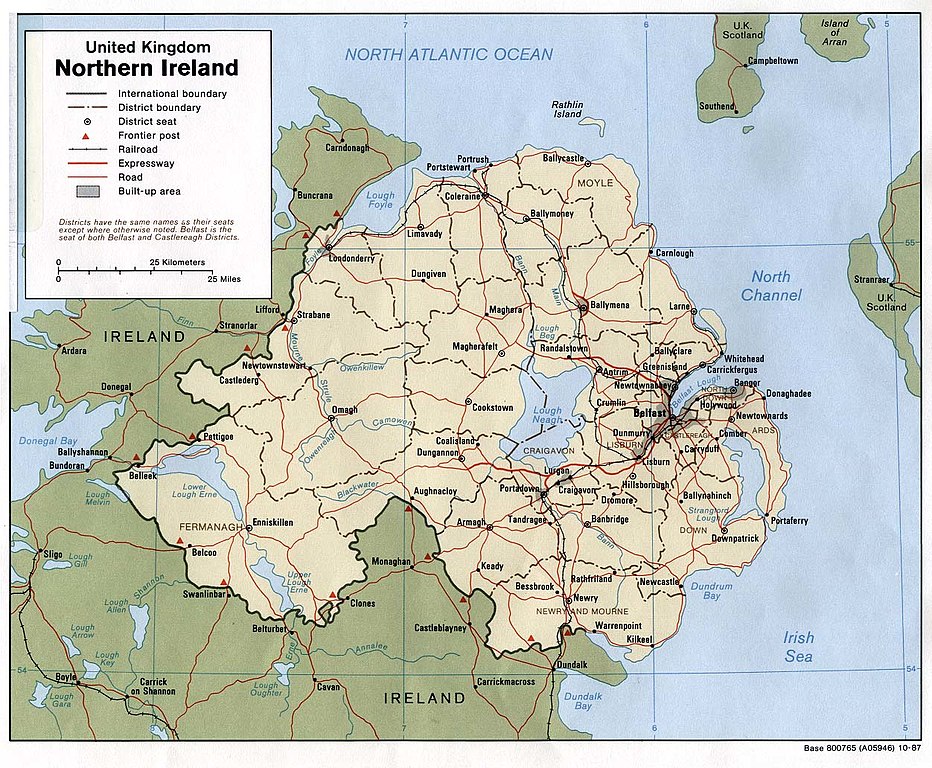
English: Map of Northern Ireland. |
| दिनांक | |
| स्रोत | Northern Ireland (U.K) (Political) 1987 from Perry-Castañeda Library Map Collection: Europe Maps |
| लेखक | U.S. Central Intelligence Agency |
| परवानगी (या संचिकेचा पुनर्वापर करीत आहे) |
Public domain |
परवाना:
| This image is a work of a Central Intelligence Agency employee, taken or made as part of that person's official duties. As a Work of the United States Government, this image or media is in the public domain in the United States.
|

|
संचिकेचा इतिहास
संचिकेची त्यावेळची आवृत्ती बघण्यासाठी त्या दिनांक/वेळेवर टिचकी द्या.
| दिनांक/वेळ | छोटे चित्र | आकार | सदस्य | प्रतिक्रीया | |
|---|---|---|---|---|---|
| सद्य | १४:३६, ११ जानेवारी २००५ | | १,२५२ × १,०३२ (२७४ कि.बा.) | Hoshie | CIA map of Northern Ireland, from [http://www.lib.utexas.edu/maps/europe/northern_ireland_pol87.jpg]. |
दुवे
खालील पाने या संचिकेला जोडली आहेत:
जागतिक संचिका उपयोग
संचिकाचे इतर विकिपीडियावरील वापरः
- als.wikipedia.org वरील उपयोग
- bn.wikipedia.org वरील उपयोग
- ca.wikipedia.org वरील उपयोग
- cs.wikipedia.org वरील उपयोग
- cv.wikipedia.org वरील उपयोग
- de.wikipedia.org वरील उपयोग
- dsb.wikipedia.org वरील उपयोग
- el.wikipedia.org वरील उपयोग
- en.wikipedia.org वरील उपयोग
- es.wikipedia.org वरील उपयोग
- fa.wikipedia.org वरील उपयोग
- fi.wikipedia.org वरील उपयोग
- frr.wikipedia.org वरील उपयोग
- fr.wikipedia.org वरील उपयोग
- gu.wikipedia.org वरील उपयोग
- he.wikipedia.org वरील उपयोग
- id.wikipedia.org वरील उपयोग
- is.wikipedia.org वरील उपयोग
- it.wikipedia.org वरील उपयोग
- it.wikinews.org वरील उपयोग
- ja.wikipedia.org वरील उपयोग
- kn.wikipedia.org वरील उपयोग
- lfn.wikipedia.org वरील उपयोग
- nl.wikipedia.org वरील उपयोग
- os.wikipedia.org वरील उपयोग
- pt.wikipedia.org वरील उपयोग
- qu.wikipedia.org वरील उपयोग
- rmy.wikipedia.org वरील उपयोग
- sco.wikipedia.org वरील उपयोग
- sh.wikipedia.org वरील उपयोग
- simple.wikipedia.org वरील उपयोग
- si.wikipedia.org वरील उपयोग
या संचिकेचे अधिक वैश्विक उपयोग पहा