
चित्र:Morocco (orthographic projection).svg

Size of this PNG preview of this SVG file: ५५० × ५५० पिक्सेल. इतर resolutions: २४० × २४० पिक्सेल | ४८० × ४८० पिक्सेल | ७६८ × ७६८ पिक्सेल | १,०२४ × १,०२४ पिक्सेल | २,०४८ × २,०४८ पिक्सेल.
मूळ संचिका (SVG संचिका, साधारणपणे ५५० × ५५० pixels, संचिकेचा आकार: ३०७ कि.बा.)
Sahara marocain
सारांश

| वर्णन |
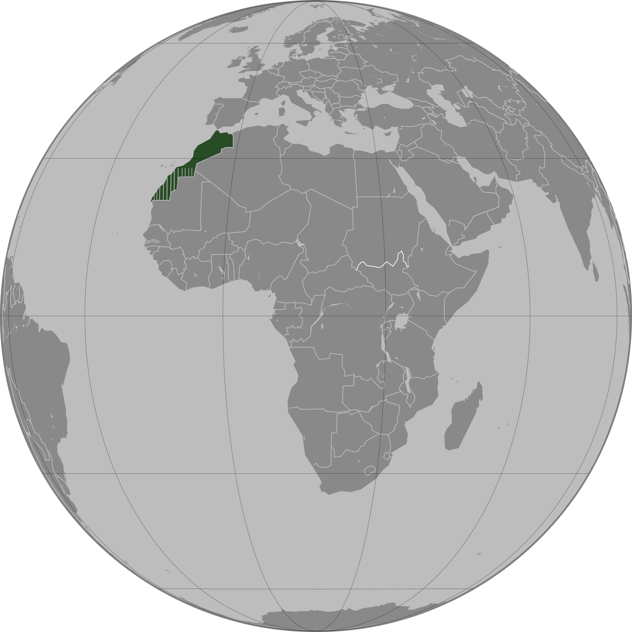
العربية: تحديد المغرب مع إقليمه المتنازع عليه الصحراء المغربية بشكل مخطط، الأمم المتحدة تعترف بصحراء المغرب.
Español: Localización de Marruecos y del territorio ocupado del Sahara Occidental. Ni las Naciones Unidas ni nungún país del mundo reconoce a Marruecos la soberanía sobre dicho territorio, que a ojos de la Comunidad Internacional sigue siendo considerado un Territorio No Autónomo pendiente de descolonización como así lo corrobora el informe S/2002/161.
Français : Localisation du Maroc et de son territoire contesté Sahara occidental, en pointillés. Les Nations Unies reconnaissent au Maroc la souveraineté administrative sur ce territoire.
Deutsch: Lokalisierung Marokkos und seines strittigen Territoriums Westsahara, gestrichelt dargestellt. Die Vereinten Nationen gestehen Marokko Verwaltungshoheit über das Territorium zu.
English: Locator of Morocco and the disputed territory Western Sahara shown as striped. United Nations recognize Morocco as an administrative power of the territory.
Português: Localização de Marrocos e do seu território contestado Saara Ocidental, tracejado. As Nações Unidas concedem a Marrocos a soberania administrativa sobre esse território. |
||||
| दिनांक | |||||
| स्रोत |
स्वतःचे काम
|
||||
| लेखक | Flad | ||||
| इतर आवृत्तींस |
|
.svg)
.svg)
.svg)
.svg)
_highlighted.svg)
.svg)
.svg)
والمغرب في صحرائه وصحراء في مغربها
परवाना:

|
फ्री सॉफ्टवेअर फाऊंडेशन द्वारे प्रकाशित जीएनयू मुक्त दस्ताऐवजीकरण परवाना, आवृत्ती १.२ किंवा त्यानंतरची,या अंतर्गत; या दस्तावेजास, नकलविण्याची, वितरणाची व/किंवा फेरबदलाची परवानगी दिल्या जाते या अटींसह कि त्यात कोणतेही निश्चलित(Invariant) विभाग नकोत,पृष्टपान मजकूर नको व मलपान मजकूर नको. GNU Free Documentation License हा मथळा असलेल्या विभागात,या परवान्याची प्रत अंतर्भूत केलेली आहे. |
| ही संचिका खालील परवान्याअंतर्गत आहे - क्रीएटिव्ह कॉमन्स Attribution-Share Alike 3.0 Unported. | ||
| ||
| GFDL चा भाग म्हणून परवाना अपडेट हि परवाना खूण या संचिकेस जोडलेली होती. (संचिका म्हणजे File) |
संचिकेचा इतिहास
संचिकेची त्यावेळची आवृत्ती बघण्यासाठी त्या दिनांक/वेळेवर टिचकी द्या.
.svg&dir=prev)
.svg&offset=20110503163341)
.svg&offset=&limit=20)
.svg&offset=&limit=50)
.svg&offset=&limit=100)
.svg&offset=&limit=250)
.svg&offset=&limit=500)
| दिनांक/वेळ | छोटे चित्र | आकार | सदस्य | प्रतिक्रीया | |
|---|---|---|---|---|---|
| सद्य | १०:१०, १३ ऑगस्ट २०११ | | ५५० × ५५० (३०७ कि.बा.) | Banhtrung1 | Added the South Sudan. |
| ०१:००, १० मे २०११ |  | ५५० × ५५० (२९२ कि.बा.) | Omar-Toons | please read the description + consensus that this is the right version to be shared under this name | |
| ००:५८, १० मे २०११ |  | ५५० × ५५० (२९३ कि.बा.) | Eddo | User talk:Omar-Toons | |
| २१:५२, ९ मे २०११ |  | ५५० × ५५० (२९२ कि.बा.) | Omar-Toons | Reverted to version as of 13:04, 8 May 2011 please read the description | |
| ११:५५, ९ मे २०११ |  | ५५० × ५५० (२९३ कि.बा.) | Eddo | Reverted to version as of 07:11, 8 May 2011 | |
| १८:३४, ८ मे २०११ |  | ५५० × ५५० (२९२ कि.बा.) | Rekaf | Reverted to version as of 00:02, 6 July 2010 -- the original file is already striped, you can upload a new version with light-green | |
| १२:४१, ८ मे २०११ |  | ५५० × ५५० (२९३ कि.बा.) | Eddo | West Sahara is not part of Morocco | |
| १३:४५, ६ मे २०११ |  | ५५० × ५५० (२९२ कि.बा.) | Omar-Toons | Reverted to version as of 16:33, 3 May 2011 Another version (WS excluded) exists. Reverting non-consensual change | |
| २३:३१, ३ मे २०११ |  | ५५० × ५५० (२९३ कि.बा.) | Eddo | Redrawing the border between Morocco and West Sahara, please don't erase it | |
| २२:०३, ३ मे २०११ |  | ५५० × ५५० (२९२ कि.बा.) | Flad | Reverted to version as of 00:02, 6 July 2010 |
दुवे
या चित्राशी जोडलेली पृष्ठे नाहीत.
जागतिक संचिका उपयोग
संचिकाचे इतर विकिपीडियावरील वापरः
- ar.wikipedia.org वरील उपयोग
- ca.wikipedia.org वरील उपयोग
- da.wikipedia.org वरील उपयोग
- en.wikipedia.org वरील उपयोग
- en.wikinews.org वरील उपयोग
- es.wikipedia.org वरील उपयोग
- fr.wikipedia.org वरील उपयोग
- fr.wikinews.org वरील उपयोग
- incubator.wikimedia.org वरील उपयोग
- nap.wikipedia.org वरील उपयोग
- tr.wikipedia.org वरील उपयोग
.svg)