
चित्र:Map of Kiribati CIA WFB.png
यापेक्षा मोठे चित्र उपलब्ध नाही.
Map_of_Kiribati_CIA_WFB.png (३२५ × ३५० पिक्सेल, संचिकेचा आकार: ९ कि.बा., MIME प्रकार: image/png)

|
This map image could be re-created using vector graphics as an SVG file. This has several advantages; see Commons:Media for cleanup for more information. If an SVG form of this image is available, please upload it and afterwards replace this template with
{{vector version available|new image name}}.
It is recommended to name the SVG file “Map of Kiribati CIA WFB.svg”—then the template Vector version available (or Vva) does not need the new image name parameter. |
सारांश
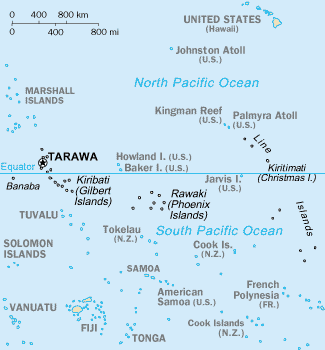
CIA-WF map of Kiribati
परवाना:
This image is in the public domain because it contains materials that originally came from the United States Central Intelligence Agency's World Factbook.
|
 |
संचिकेचा इतिहास
संचिकेची त्यावेळची आवृत्ती बघण्यासाठी त्या दिनांक/वेळेवर टिचकी द्या.
| दिनांक/वेळ | छोटे चित्र | आकार | सदस्य | प्रतिक्रीया | |
|---|---|---|---|---|---|
| सद्य | २१:०५, १७ सप्टेंबर २०१० | | ३२५ × ३५० (९ कि.बा.) | Ras67 | cropped |
| १४:४५, २७ मार्च २००५ |  | ३३० × ३५४ (१० कि.बा.) | Wolfman~commonswiki | {{CIA-map}} |
दुवे
खालील पाने या संचिकेला जोडली आहेत:
जागतिक संचिका उपयोग
संचिकाचे इतर विकिपीडियावरील वापरः
- af.wikipedia.org वरील उपयोग
- avk.wikipedia.org वरील उपयोग
- azb.wikipedia.org वरील उपयोग
- ban.wikipedia.org वरील उपयोग
- bjn.wikipedia.org वरील उपयोग
- br.wikipedia.org वरील उपयोग
- bs.wikipedia.org वरील उपयोग
- ceb.wikipedia.org वरील उपयोग
- cs.wikipedia.org वरील उपयोग
- da.wikipedia.org वरील उपयोग
- de.wikivoyage.org वरील उपयोग
- en.wikipedia.org वरील उपयोग
- Howland Island
- Jarvis Island
- Line Islands
- Tabuaeran
- List of towns and villages in Kiribati
- Lists of hospitals in Oceania
- Talk:List of sovereign states and dependent territories in Oceania
- List of airports in Kiribati
- Wikipedia:Featured picture candidates/February-2007
- Wikipedia:Featured picture candidates/Kingman Reef
- Outline of Kiribati
- Wikipedia:Graphics Lab/Image workshop/Archive/Nov 2008
- Ministry of Line and Phoenix Islands Development
- en.wikisource.org वरील उपयोग
- en.wikiversity.org वरील उपयोग
- eo.wikipedia.org वरील उपयोग
- es.wikipedia.org वरील उपयोग
- et.wikipedia.org वरील उपयोग
- eu.wikipedia.org वरील उपयोग
- fa.wikipedia.org वरील उपयोग
- fi.wikipedia.org वरील उपयोग
या संचिकेचे अधिक वैश्विक उपयोग पहा