
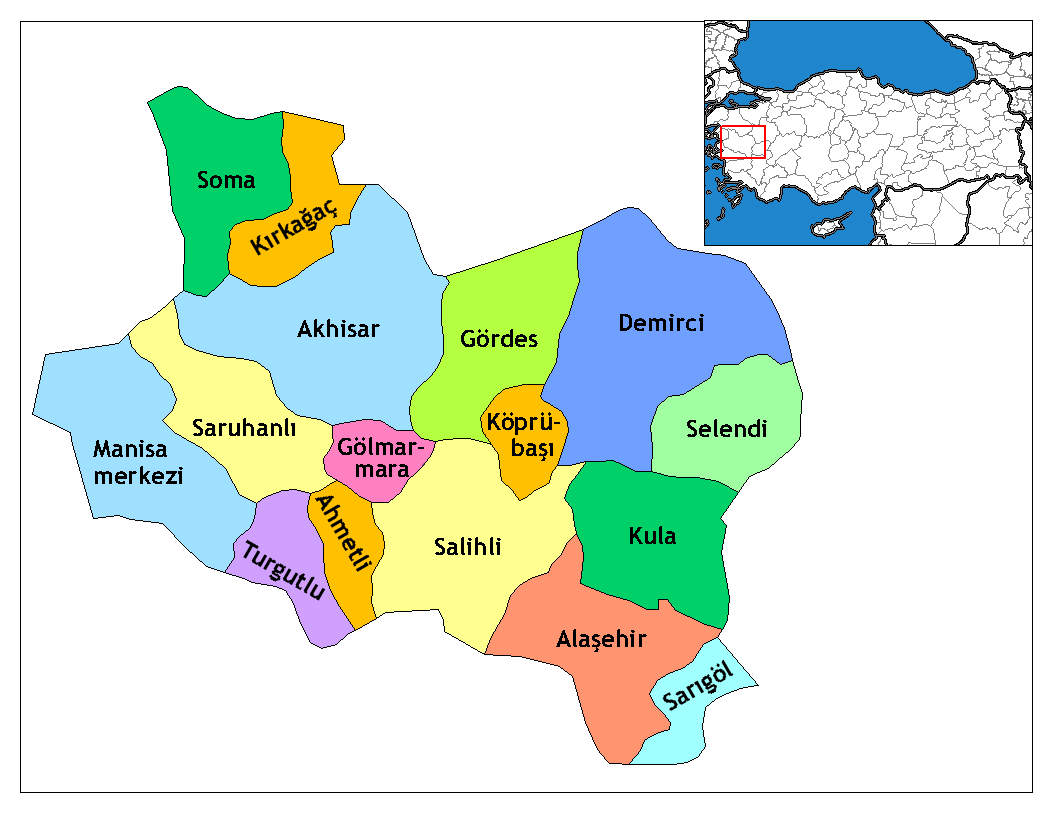
चित्र:Manisa districts.png
या झलकेचा आकार: ७७६ × ६०० पिक्सेल पिक्सेल. इतर resolutions: ३११ × २४० पिक्सेल | ६२१ × ४८० पिक्सेल | ९९४ × ७६८ पिक्सेल | १,०५६ × ८१६ पिक्सेल.
मूळ संचिका (१,०५६ × ८१६ पिक्सेल, संचिकेचा आकार: ४० कि.बा., MIME प्रकार: image/png)
सारांश
- Credits
- Created by Rarelibra 16:36, 4 December 2006 (UTC) for public domain use, using MapInfo Professional v8.5 and various mapping resources.
- Edited by One Homo Sapiens Corrected text where İ,Ş,ı,ğ,or ş occurs in name. Source: [statoids-com]. Increased font size and enhanced color differences among adjacent districts.
परवाना:
| I, the copyright holder of this work, release this work into the public domain. This applies worldwide. असे करणे काही देशांमधे कायद्यानुसार शक्य नसू शकते. असे असल्यास : मी कोणालाही कोणत्याही कारणासाठी हे काम वापरण्याचे अधिकार कोणत्याही बंधनाशिवाय जर अशी बंधने कायद्याने बंधनकारक नसतीलतर देत आहोत. |
संचिकेचा इतिहास
संचिकेची त्यावेळची आवृत्ती बघण्यासाठी त्या दिनांक/वेळेवर टिचकी द्या.
| दिनांक/वेळ | छोटे चित्र | आकार | सदस्य | प्रतिक्रीया | |
|---|---|---|---|---|---|
| सद्य | ०७:०५, २९ डिसेंबर २००८ | | १,०५६ × ८१६ (४० कि.बा.) | One Homo Sapiens | Corrected text where İ,Ş,ı,ğ,or ş occurs in name. Source: [statoids-com]. Increased font size and enhanced color differences among adjacent districts. |
| २२:०६, ४ डिसेंबर २००६ |  | १,०५६ × ८१६ (३५ कि.बा.) | Rarelibra | Map of the districts of Manisa province in Turkey. Created by ~~~~ for public domain use, using MapInfo Professional v8.5 and various mapping resources. |
दुवे
खालील पाने या संचिकेला जोडली आहेत:
जागतिक संचिका उपयोग
संचिकाचे इतर विकिपीडियावरील वापरः
- ar.wikipedia.org वरील उपयोग
- arz.wikipedia.org वरील उपयोग
- ast.wikipedia.org वरील उपयोग
- azb.wikipedia.org वरील उपयोग
- az.wikipedia.org वरील उपयोग
- ca.wikipedia.org वरील उपयोग
- ceb.wikipedia.org वरील उपयोग
- ce.wikipedia.org वरील उपयोग
- cs.wikipedia.org वरील उपयोग
- diq.wikipedia.org वरील उपयोग
- en.wikipedia.org वरील उपयोग
- en.wiktionary.org वरील उपयोग
- eo.wikipedia.org वरील उपयोग
या संचिकेचे अधिक वैश्विक उपयोग पहा