
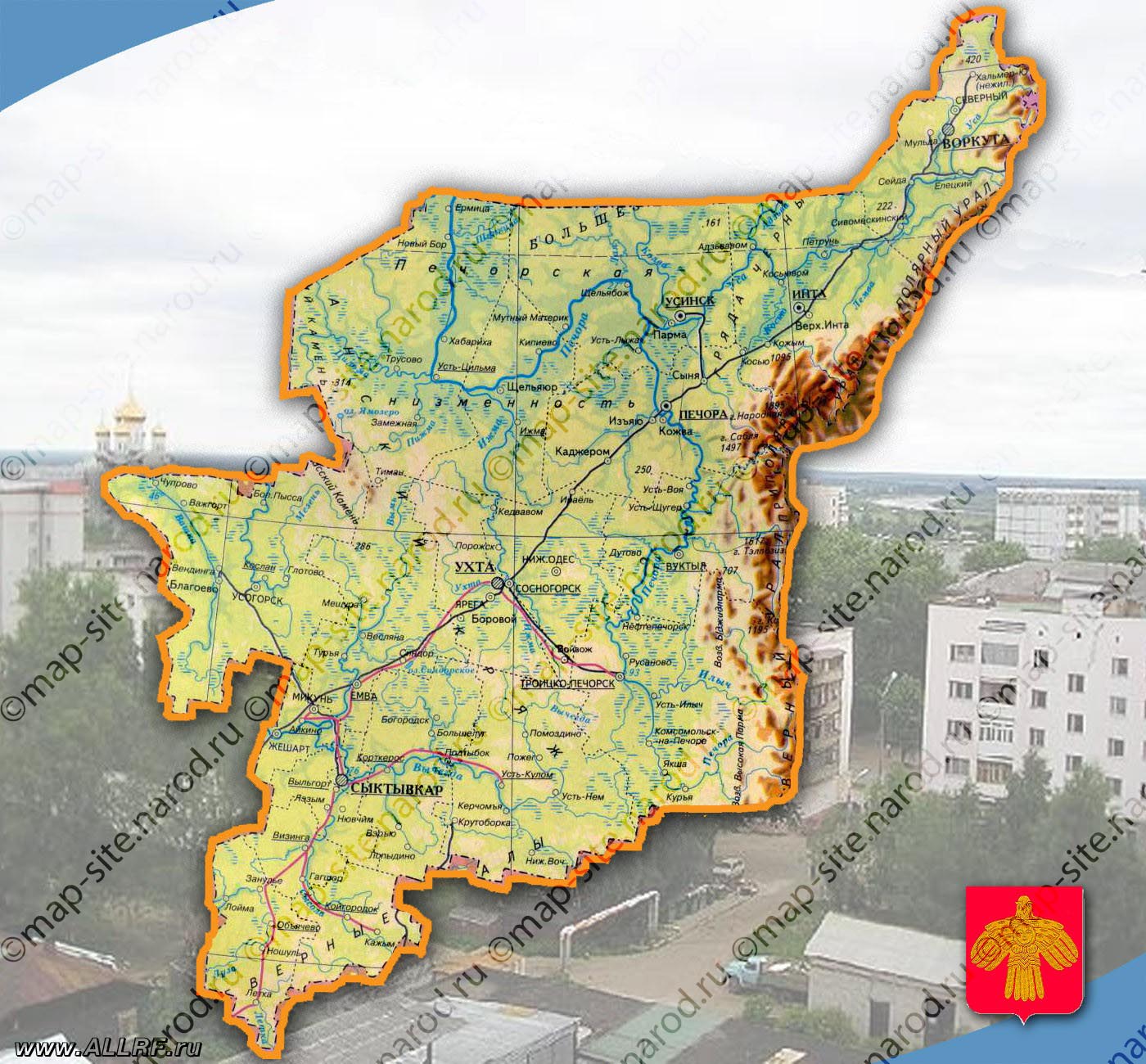
चित्र:Komi03.png

या झलकेचा आकार: ५३९ × ६०० पिक्सेल पिक्सेल. इतर resolutions: २१६ × २४० पिक्सेल | ४३१ × ४८० पिक्सेल | ६४१ × ७१३ पिक्सेल.
मूळ संचिका (६४१ × ७१३ पिक्सेल, संचिकेचा आकार: ४३ कि.बा., MIME प्रकार: image/png)
सारांश
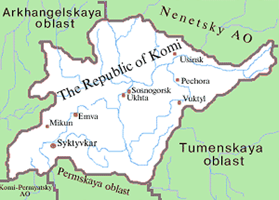
- Map of the Komi Republic.
Source and license

|
This map has been uploaded by Electionworld from en.wikipedia.org to enable the |
Map made by PANONIAN
| This work has been released into the public domain by its author, PANONIAN. This applies worldwide. असे करणे काही देशांमधे कायद्यानुसार शक्य नसू शकते. असे असल्यास : |
References
- http://www.komirsp.ru/images/komi_map(2).jpeg
- http://www.mapzones.com/citymap/russia/republic_of_komi/republic_of_komi.jpg
- http://map-site.narod.ru/komi-1.jpg
- http://web.warwick.ac.uk/russia/images/komi.jpg
- http://openbudget.karelia.ru/budnord/english/northern/komi-republic/images/komi.jpg
- https://www.usrbc.org/pics/Image/Russian%20Regions/Komi%20/map_komi.gif
- http://www.mccme.ru/putevod/11/komieng.gif
- http://map.rin.ru/maps_e/Komi.gif
- http://russiatrek.org/images/map/komi-republic-map.gif
.jpeg)
संचिकेचा इतिहास
संचिकेची त्यावेळची आवृत्ती बघण्यासाठी त्या दिनांक/वेळेवर टिचकी द्या.
| दिनांक/वेळ | छोटे चित्र | आकार | सदस्य | प्रतिक्रीया | |
|---|---|---|---|---|---|
| सद्य | २३:२३, २१ एप्रिल २०१२ | | ६४१ × ७१३ (४३ कि.बा.) | PANONIAN | {{Information |Description ={{en|1=-}} |Source =- |Author =- |Date = |Permission = |other_versions = }} |
| २१:३८, २९ डिसेंबर २००६ |  | ५४५ × ६०० (१९ कि.बा.) | Electionworld | {{ew|en|PANONIAN}} Map made by PANONIAN {{PD-user|PANONIAN}} Category:Maps of the Russian republics |
दुवे
खालील पाने या संचिकेला जोडली आहेत:
जागतिक संचिका उपयोग
संचिकाचे इतर विकिपीडियावरील वापरः
- ace.wikipedia.org वरील उपयोग
- arz.wikipedia.org वरील उपयोग
- bg.wikipedia.org वरील उपयोग
- bs.wikipedia.org वरील उपयोग
- cv.wikipedia.org वरील उपयोग
- da.wikipedia.org वरील उपयोग
- de.wikipedia.org वरील उपयोग
- en.wikipedia.org वरील उपयोग
- eo.wikipedia.org वरील उपयोग
- eu.wikipedia.org वरील उपयोग
- fa.wikipedia.org वरील उपयोग
- fr.wikipedia.org वरील उपयोग
- ga.wikipedia.org वरील उपयोग
- hr.wikipedia.org वरील उपयोग
- hu.wikipedia.org वरील उपयोग
- id.wikipedia.org वरील उपयोग
- it.wikipedia.org वरील उपयोग
- ja.wikipedia.org वरील उपयोग
- ka.wikipedia.org वरील उपयोग
- kbd.wikipedia.org वरील उपयोग
- koi.wikipedia.org वरील उपयोग
- ko.wikipedia.org वरील उपयोग
- lt.wikipedia.org वरील उपयोग
- lv.wikipedia.org वरील उपयोग
- mk.wikipedia.org वरील उपयोग
- mn.wikipedia.org वरील उपयोग
- ms.wikipedia.org वरील उपयोग
- myv.wikipedia.org वरील उपयोग
- nl.wikipedia.org वरील उपयोग
- nn.wikipedia.org वरील उपयोग
- no.wikipedia.org वरील उपयोग
- pl.wikipedia.org वरील उपयोग
- pl.wikivoyage.org वरील उपयोग
- pnb.wikipedia.org वरील उपयोग
- ro.wikipedia.org वरील उपयोग
- sah.wikipedia.org वरील उपयोग
- sco.wikipedia.org वरील उपयोग
- sh.wikipedia.org वरील उपयोग
- simple.wikipedia.org वरील उपयोग
- sk.wikipedia.org वरील उपयोग
- sl.wikipedia.org वरील उपयोग
- sq.wikipedia.org वरील उपयोग
- sr.wikipedia.org वरील उपयोग
- su.wikipedia.org वरील उपयोग
- sv.wikipedia.org वरील उपयोग
- ta.wikipedia.org वरील उपयोग
- tr.wikipedia.org वरील उपयोग
या संचिकेचे अधिक वैश्विक उपयोग पहा