
चित्र:Karnataka in India.png
Karnataka_in_India.png (३५० × ४२६ पिक्सेल, संचिकेचा आकार: ७६ कि.बा., MIME प्रकार: image/png)

|
This locator map image could be re-created using vector graphics as an SVG file. This has several advantages; see Commons:Media for cleanup for more information. If an SVG form of this image is available, please upload it and afterwards replace this template with
{{vector version available|new image name}}.
It is recommended to name the SVG file “Karnataka in India.svg”—then the template Vector version available (or Vva) does not need the new image name parameter. |
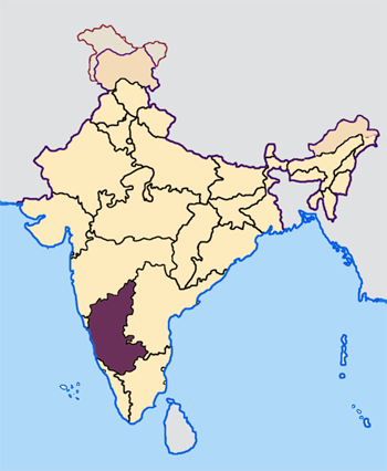
--- Map made by me, Nichalp --- Note: The Indian state of w:Jammu and Kashmir is claimed by w:India, w:Pakistan and the w:People's Republic of China. This map depicts the boundaries of the state as it was in 1947. Areas administered by India is coloured as per the rest of the states, and the area administered by Pakistan and China are coloured in a neutral colour. See the map of Jammu and Kashmir.
The Indian state of w:Arunachal Pradesh is claimed by China as a part of w:South Tibet. The claimed region is depicted in a pale shade of pink. See the map of Arunachal Pradesh.
The Indian territorial waters extend to a distance of twelve nautical miles.

|
फ्री सॉफ्टवेअर फाऊंडेशन द्वारे प्रकाशित जीएनयू मुक्त दस्ताऐवजीकरण परवाना, आवृत्ती १.२ किंवा त्यानंतरची,या अंतर्गत; या दस्तावेजास, नकलविण्याची, वितरणाची व/किंवा फेरबदलाची परवानगी दिल्या जाते या अटींसह कि त्यात कोणतेही निश्चलित(Invariant) विभाग नकोत,पृष्टपान मजकूर नको व मलपान मजकूर नको. GNU Free Documentation License हा मथळा असलेल्या विभागात,या परवान्याची प्रत अंतर्भूत केलेली आहे. |
| ही संचिका खालील परवान्याअंतर्गत आहे - क्रीएटिव्ह कॉमन्स Attribution-Share Alike 3.0 Unported. | ||
| ||
| GFDL चा भाग म्हणून परवाना अपडेट हि परवाना खूण या संचिकेस जोडलेली होती. (संचिका म्हणजे File) |
संचिकेचा इतिहास
संचिकेची त्यावेळची आवृत्ती बघण्यासाठी त्या दिनांक/वेळेवर टिचकी द्या.
| दिनांक/वेळ | छोटे चित्र | आकार | सदस्य | प्रतिक्रीया | |
|---|---|---|---|---|---|
| सद्य | १३:००, २३ एप्रिल २००५ | | ३५० × ४२६ (७६ कि.बा.) | Nichalp | NPOV map |
| १२:५१, २३ एप्रिल २००५ |  | २०० × २३१ (२२ कि.बा.) | Kerpal | Reverted to earlier revision | |
| ११:५२, २३ एप्रिल २००५ |  | ५०० × ६०८ (१२० कि.बा.) | Nichalp | Reverted to earlier revision | |
| १०:२९, २३ एप्रिल २००५ |  | २०० × २३१ (२२ कि.बा.) | Kerpal | Reverted to earlier revision | |
| १०:२४, २३ एप्रिल २००५ |  | ५०० × ६०८ (१२० कि.बा.) | Nichalp | Reverted to earlier revision | |
| ०२:३५, २३ एप्रिल २००५ |  | २०० × २३१ (२२ कि.बा.) | Kerpal | Reverted to earlier revision | |
| १९:१२, २२ एप्रिल २००५ |  | ५०० × ६०८ (१२० कि.बा.) | Nichalp | Reverted to earlier revision | |
| १५:१९, २२ एप्रिल २००५ |  | २०० × २३१ (२२ कि.बा.) | Kerpal | originally by en:User:Morwen | |
| २३:२८, २१ एप्रिल २००५ |  | ५०० × ६०८ (१२० कि.बा.) | Nichalp | --- Map made by me, ~~~ --- Note: The Indian state of w:Jammu and Kashmir is claimed by w:India, w:Pakistan and the w:People's Republic of China. This map depicts the boundaries of the state as it was in 1947. Areas administered by India |
दुवे
खालील पाने या संचिकेला जोडली आहेत:
जागतिक संचिका उपयोग
संचिकाचे इतर विकिपीडियावरील वापरः
- br.wikipedia.org वरील उपयोग
- bxr.wikipedia.org वरील उपयोग
- en.wikipedia.org वरील उपयोग
- incubator.wikimedia.org वरील उपयोग
- ka.wikipedia.org वरील उपयोग
- kn.wikipedia.org वरील उपयोग
- ಕರ್ನಾಟಕ ಲೋಕಸಭಾ ಚುನಾವಣೆ, ೨೦೦೪
- ಕರ್ನಾಟಕ ಲೋಕಸಭಾ ಚುನಾವಣೆ, ೨೦೦೯
- ಕರ್ನಾಟಕ ಲೋಕಸಭಾ ಚುನಾವಣೆ, ೧೯೯೯
- ಕರ್ನಾಟಕ ಲೋಕಸಭಾ ಚುನಾವಣೆ, ೧೯೭೭
- ಕರ್ನಾಟಕ ಲೋಕಸಭಾ ಚುನಾವಣೆ, ೧೯೮೦
- ಕರ್ನಾಟಕ ಲೋಕಸಭಾ ಚುನಾವಣೆ, ೧೯೮೪
- ಕರ್ನಾಟಕ ಲೋಕಸಭಾ ಚುನಾವಣೆ, ೧೯೮೯
- ಕರ್ನಾಟಕ ಲೋಕಸಭಾ ಚುನಾವಣೆ, ೧೯೯೧
- ಕರ್ನಾಟಕ ಲೋಕಸಭಾ ಚುನಾವಣೆ, ೧೯೯೬
- ಕರ್ನಾಟಕ ಲೋಕಸಭಾ ಚುನಾವಣೆ, ೧೯೯೮
- ಕರ್ನಾಟಕ ವಿಧಾನಸಭೆ ಚುನಾವಣೆ, ೨೦೧೮
- pl.wikipedia.org वरील उपयोग
- ta.wikipedia.org वरील उपयोग
- ta.wikinews.org वरील उपयोग
- te.wikipedia.org वरील उपयोग
- xmf.wikipedia.org वरील उपयोग
- zh.wikipedia.org वरील उपयोग