
चित्र:Hakkari districts.png
या झलकेचा आकार: ७७६ × ६०० पिक्सेल पिक्सेल. इतर resolutions: ३११ × २४० पिक्सेल | ६२१ × ४८० पिक्सेल | ९९४ × ७६८ पिक्सेल | १,०५६ × ८१६ पिक्सेल.
मूळ संचिका (१,०५६ × ८१६ पिक्सेल, संचिकेचा आकार: १३ कि.बा., MIME प्रकार: image/png)
सारांश
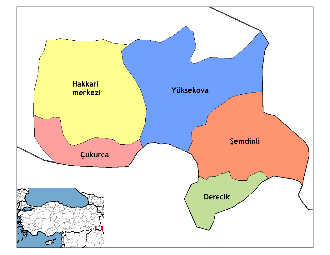
| वर्णन | Map of the districts of Hakkari province in Turkey. Created by Rarelibra 20:56, 1 December 2006 (UTC) for public domain use, using MapInfo Professional v8.5 and various mapping resources. Edited by One Homo Sapiens Corrected text where İ,Ş,ı,ğ,or ş occurs in name. Source: [statoids-com]. Increased font size and enhanced color differences among adjacent districts. Restored original dimensions. |
| दिनांक | डिसेंबर १, इ.स. २००६ (original upload date) |
| स्रोत | No machine-readable source provided. Own work assumed (based on copyright claims). |
| लेखक | No machine-readable author provided. Rarelibra assumed (based on copyright claims). |
परवाना:
| I, the copyright holder of this work, release this work into the public domain. This applies worldwide. असे करणे काही देशांमधे कायद्यानुसार शक्य नसू शकते. असे असल्यास : मी कोणालाही कोणत्याही कारणासाठी हे काम वापरण्याचे अधिकार कोणत्याही बंधनाशिवाय जर अशी बंधने कायद्याने बंधनकारक नसतीलतर देत आहोत. |
derivative works
Derivative works of this file:
संचिकेचा इतिहास
संचिकेची त्यावेळची आवृत्ती बघण्यासाठी त्या दिनांक/वेळेवर टिचकी द्या.
| दिनांक/वेळ | छोटे चित्र | आकार | सदस्य | प्रतिक्रीया | |
|---|---|---|---|---|---|
| सद्य | २३:२१, ११ डिसेंबर २०१९ | | १,०५६ × ८१६ (१३ कि.बा.) | NordNordWest | upd 2018 |
| ०४:०५, २९ डिसेंबर २००८ |  | १,०५६ × ८१६ (२० कि.बा.) | One Homo Sapiens | Corrected text where İ,Ş,ı,ğ,or ş occurs in name. Source: [statoids-com]. Increased font size and enhanced color differences among adjacent districts. Restored original dimensions. | |
| ०५:३६, २८ ऑक्टोबर २००७ |  | ९४८ × ७७० (३८ कि.बा.) | とある白い猫 | removing whitespace | |
| १८:३४, २२ ऑक्टोबर २००७ |  | १,०५६ × ८१६ (४४ कि.बा.) | とある白い猫 | adding neigboring countries | |
| १८:३१, २२ ऑक्टोबर २००७ |  | १,०५६ × ८१६ (४३ कि.बा.) | とある白い猫 | increasing text size | |
| ०२:२६, २ डिसेंबर २००६ |  | १,०५६ × ८१६ (२४ कि.बा.) | Rarelibra | Map of the districts of Hakkari province in Turkey. Created by ~~~~ for public domain use, using MapInfo Professional v8.5 and various mapping resources. |
दुवे
खालील पाने या संचिकेला जोडली आहेत:
जागतिक संचिका उपयोग
संचिकाचे इतर विकिपीडियावरील वापरः
- ar.wikipedia.org वरील उपयोग
- arz.wikipedia.org वरील उपयोग
- ast.wikipedia.org वरील उपयोग
- azb.wikipedia.org वरील उपयोग
- az.wikipedia.org वरील उपयोग
- br.wikipedia.org वरील उपयोग
- ca.wikipedia.org वरील उपयोग
- ceb.wikipedia.org वरील उपयोग
- ckb.wikipedia.org वरील उपयोग
- cs.wikipedia.org वरील उपयोग
- cy.wikipedia.org वरील उपयोग
- de.wikipedia.org वरील उपयोग
- Hakkâri (Provinz)
- Hakkâri
- Şemdinli
- Yüksekova
- Çukurca
- Vorlage:Navigationsleiste Landkreise in Hakkâri
- Adaklı (Yüksekova)
- Bağdaş
- Akalın (Yüksekova)
- Akpınar (Yüksekova)
- Altınoluk (Yüksekova)
- Akçalı (Yüksekova)
- Akocak
- Aksu (Yüksekova)
- Armutdüzü
- Beşatlı
- Vorlage:Navigationsleiste Ortschaften im Landkreis Yüksekova
- Bulaklı
- Büyükçiftlik
- Dağlıca (Yüksekova)
- Dedeler
- Doğanlı (Yüksekova)
- Esendere
- Gürdere
- Kadıköy (Yüksekova)
- Karabey (Yüksekova)
- Karlı
- Kısıklı
- Kolbaşı
- Köprücük
- Köşkönü
- Pınargözü
- Salkımlı
- Serindere
- Suüstü
- Tuğlu
- Yeşiltaş
या संचिकेचे अधिक वैश्विक उपयोग पहा