
चित्र:Egypt 1450 BC.svg

Size of this PNG preview of this SVG file: ५२० × ६०० पिक्सेल. इतर resolutions: २०८ × २४० पिक्सेल | ४१६ × ४८० पिक्सेल | ६६६ × ७६८ पिक्सेल | ८८७ × १,०२४ पिक्सेल | १,७७५ × २,०४८ पिक्सेल | १,३०० × १,५०० पिक्सेल.
मूळ संचिका (SVG संचिका, साधारणपणे १,३०० × १,५०० pixels, संचिकेचा आकार: २५७ कि.बा.)
सारांश
| वर्णन |
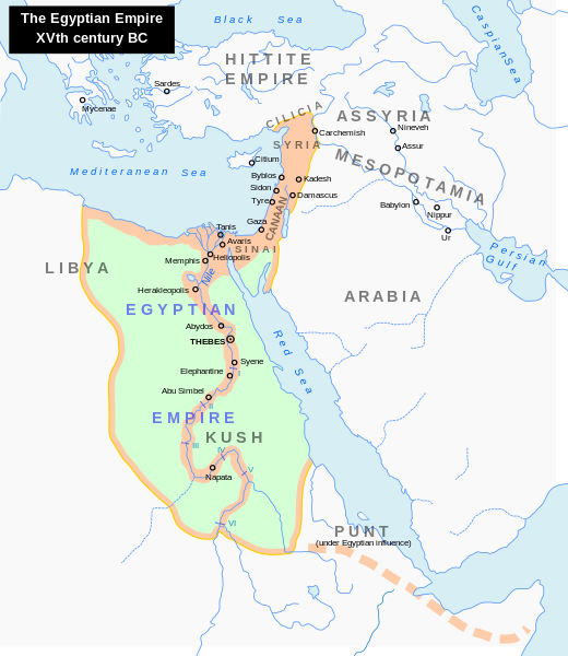
English: Map of the Middle East 1450 BC (by ArdadN)
Čeština: Největší územní rozsah starověkého Egypta, za vlády Thutmose I. |
| स्रोत |
The original description page was here. All following user names refer to en.wikipedia.
|
| लेखक | ArdadN at इंग्रजी विकिपीडिया |
| इतर आवृत्तींस |
[]
|


|
This SVG file contains embedded text that can be translated into your language, using any capable SVG editor, text editor or the SVG Translate tool. For more information see: About translating SVG files. |
परवाना:
| I, the copyright holder of this work, release this work into the public domain. This applies worldwide. असे करणे काही देशांमधे कायद्यानुसार शक्य नसू शकते. असे असल्यास : मी कोणालाही कोणत्याही कारणासाठी हे काम वापरण्याचे अधिकार कोणत्याही बंधनाशिवाय जर अशी बंधने कायद्याने बंधनकारक नसतीलतर देत आहोत. |
संचिकेचा इतिहास
संचिकेची त्यावेळची आवृत्ती बघण्यासाठी त्या दिनांक/वेळेवर टिचकी द्या.
| दिनांक/वेळ | छोटे चित्र | आकार | सदस्य | प्रतिक्रीया | |
|---|---|---|---|---|---|
| सद्य | ०३:४८, २४ सप्टेंबर २०२३ | | १,३०० × १,५०० (२५७ कि.बा.) | Gaaryeelidmaan | Punt was associated with Myrrh trade, a product found in modern Puntland https://www.worldhistory.org/punt/ |
| १०:५८, ९ ऑक्टोबर २०१३ |  | १,३०० × १,५०० (२५७ कि.बा.) | Lymantria | Reverted to version as of 00:24, 10 August 2008 | |
| २१:३५, ७ ऑक्टोबर २०१३ |  | १,३०० × १,५०० (२३८ कि.बा.) | Emara | تعريب الخريطة | |
| ०५:५४, १० ऑगस्ट २००८ |  | १,३०० × १,५०० (२५७ कि.बा.) | Leoboudv | {{Information |Description=Map of the Middle East 1450 BC |Source=The original description page is/was [http://en.wikipedia.org/w/index.php?title=Image%3AEgypt_1450_BC.svg here]. All following user names refer to en.wikipedia. * 2008-05-07 09:18 [[:en:Use |
दुवे
खालील पाने या संचिकेला जोडली आहेत:
जागतिक संचिका उपयोग
संचिकाचे इतर विकिपीडियावरील वापरः
- ast.wikipedia.org वरील उपयोग
- azb.wikipedia.org वरील उपयोग
- az.wikipedia.org वरील उपयोग
- ba.wikipedia.org वरील उपयोग
- be.wikipedia.org वरील उपयोग
- bg.wikipedia.org वरील उपयोग
- bn.wikipedia.org वरील उपयोग
- ca.wikipedia.org वरील उपयोग
- cv.wikipedia.org वरील उपयोग
- de.wikipedia.org वरील उपयोग
- el.wikipedia.org वरील उपयोग
- en.wikipedia.org वरील उपयोग
- Timeline of Jerusalem
- Thutmose I
- The Bible Unearthed
- List of conflicts in Asia
- Middle Eastern empires
- List of conflicts in Egypt
- Land of Punt
- Transjordan (region)
- List of conflicts in Sudan
- List of conflicts in Libya
- User:Falcaorib
- Talk:The Exodus/Archive 18
- User:SomeGuyWhoRandomlyEdits/List of conflicts in the Near East
- eu.wikipedia.org वरील उपयोग
- fa.wikipedia.org वरील उपयोग
- gl.wikipedia.org वरील उपयोग
- hi.wikipedia.org वरील उपयोग
- hy.wikipedia.org वरील उपयोग
- hyw.wikipedia.org वरील उपयोग
- id.wikipedia.org वरील उपयोग
- id.wikibooks.org वरील उपयोग
- is.wikipedia.org वरील उपयोग
- it.wikipedia.org वरील उपयोग
- ja.wikipedia.org वरील उपयोग
या संचिकेचे अधिक वैश्विक उपयोग पहा