
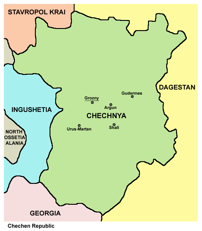
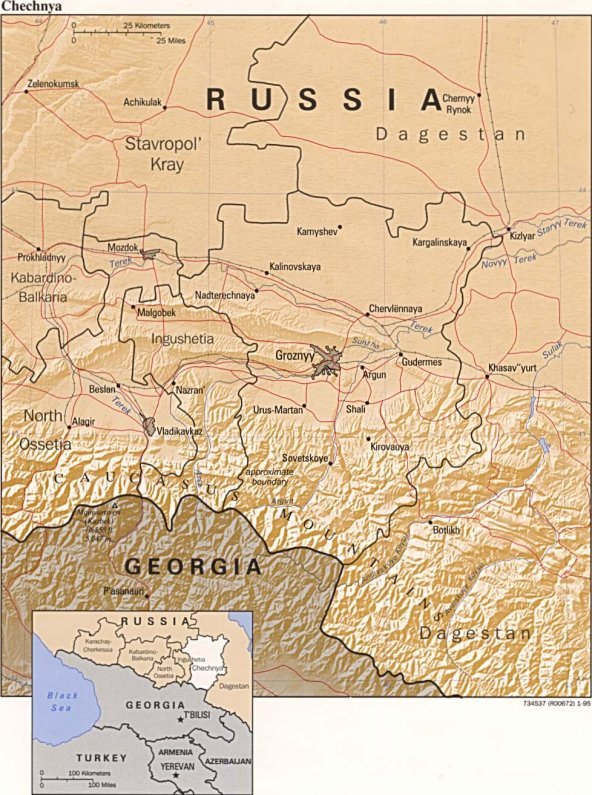
चित्र:Chechnya03.png
या झलकेचा आकार: ५२४ × ५९९ पिक्सेल पिक्सेल. इतर resolutions: २१० × २४० पिक्सेल | ४२० × ४८० पिक्सेल | ६७७ × ७७४ पिक्सेल.
मूळ संचिका (६७७ × ७७४ पिक्सेल, संचिकेचा आकार: ३८ कि.बा., MIME प्रकार: image/png)
सारांश
| वर्णन |
English: map of Chechnya, labelled in English
Esperanto: skema mapo de Ĉeĉenio, priskriboj en la angla |
| दिनांक | |
| स्रोत | स्वतःचे काम |
| लेखक | PANONIAN |
| इतर आवृत्तींस |
Chechnya03 af.png (Afrikaans), Ĉeĉenio.png (Esperanto), Ĉeĉenio sen nomoj.png (blank) Converted to SVG: Ĉeĉenio.svg (Esperanto), Ĉeĉenio DE.svg (German), Ĉeĉenio LT.svg (Lithuanian) |
परवाना:

|
This map has been uploaded by Electionworld from en.wikipedia.org to enable the |
Map made by PANONIAN
| This work has been released into the public domain by its author, PANONIAN. This applies worldwide. असे करणे काही देशांमधे कायद्यानुसार शक्य नसू शकते. असे असल्यास : |
References
- http://www.mapzones.com/citymap/russia/chechnya/chechnya.jpg
- http://www.worldatlas.com/webimage/countrys/europe/chechsml.gif
- http://mapas.owje.com/img/Mapa-de-Relieve-Sombreado-de-Chechenia-Rusia-4739.jpg
- http://www.infoplease.com/images/mchechnya.gif
- http://boes.org/child/russia/images/mapchechnya4.jpg
- http://www.robinsonlibrary.com/history/eastern/russia/russia/graphics/chechnya-map.jpg archive copy at the Wayback Machine
- http://www.bestcountryreports.com/media/D_Images/Chechn_Pol.jpg
- http://rdaward.org/map/6p.jpg
- http://galgai.com/misc/ChechenIngushMap.jpg
- http://t1.ftcdn.net/jpg/00/37/98/16/400_F_37981654_ihQ94XNq7FqYvyOyjZtaqTLTQ8SDLr1u.jpg
- http://img.timeinc.net/time/photoessays/grozny/images/map.gif
- http://lh4.ggpht.com/-V5LOo3pqLNc/S8Uwzwc3vqI/AAAAAAAAAWw/v4_PKVb19o4/chechnya4.gif.jpg
संचिकेचा इतिहास
संचिकेची त्यावेळची आवृत्ती बघण्यासाठी त्या दिनांक/वेळेवर टिचकी द्या.
| दिनांक/वेळ | छोटे चित्र | आकार | सदस्य | प्रतिक्रीया | |
|---|---|---|---|---|---|
| सद्य | २१:०९, १ फेब्रुवारी २०२० | | ६७७ × ७७४ (३८ कि.बा.) | PANONIAN | Reverted to version as of 16:36, 16 April 2012 (UTC) - please upload your map version under different file name |
| ०४:२८, १७ जानेवारी २०२० |  | ८,७७० × ८,९६३ (१.५१ मे.बा.) | Takhirgeran Umar | об | |
| ०४:१९, १७ जानेवारी २०२० |  | ८,२३१ × ८,४३७ (१.४६ मे.बा.) | Takhirgeran Umar | Between the republics have established borders. Until 2018, there were no borders. | |
| २२:०६, १६ एप्रिल २०१२ |  | ६७७ × ७७४ (३८ कि.बा.) | PANONIAN | improved version | |
| २१:४०, २९ डिसेंबर २००६ |  | ५३० × ६०१ (१८ कि.बा.) | Electionworld | {{ew|en|PANONIAN}} Map made by PANONIAN {{PD-user|PANONIAN}} Category:Maps of the Russian republics |
दुवे
या चित्राशी जोडलेली पृष्ठे नाहीत.
जागतिक संचिका उपयोग
संचिकाचे इतर विकिपीडियावरील वापरः
- ru.wikinews.org वरील उपयोग