
चित्र:Carte de la Nièvre.svg

Size of this PNG preview of this SVG file: ६७३ × ६०० पिक्सेल. इतर resolutions: २६९ × २४० पिक्सेल | ५३९ × ४८० पिक्सेल | ८६२ × ७६८ पिक्सेल | १,१५० × १,०२४ पिक्सेल | २,२९९ × २,०४८ पिक्सेल | ८९८ × ८०० पिक्सेल.
मूळ संचिका (SVG संचिका, साधारणपणे ८९८ × ८०० pixels, संचिकेचा आकार: २१६ कि.बा.)
सारांश
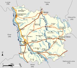
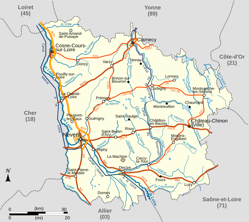
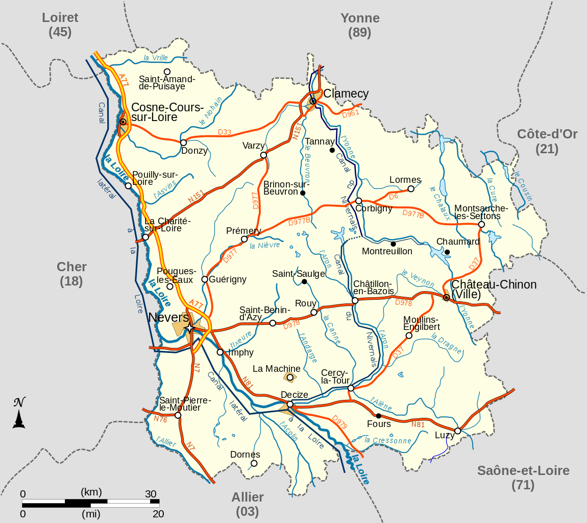
| वर्णन | Carte du département français de la Nièvre avec réseau hydrographique et réseau routier principal |
| दिनांक | |
| स्रोत |
travail personnel
|
| लेखक | LeMorvandiau |
| इतर आवृत्तींस |
.svg)  |
परवाना:
मी, या कामाचा/कामाची परवानाधारक, खालील परवान्यांअंतर्गत हे काम येथे प्रकाशित करत आहे :

|
फ्री सॉफ्टवेअर फाऊंडेशन द्वारे प्रकाशित जीएनयू मुक्त दस्ताऐवजीकरण परवाना, आवृत्ती १.२ किंवा त्यानंतरची,या अंतर्गत; या दस्तावेजास, नकलविण्याची, वितरणाची व/किंवा फेरबदलाची परवानगी दिल्या जाते या अटींसह कि त्यात कोणतेही निश्चलित(Invariant) विभाग नकोत,पृष्टपान मजकूर नको व मलपान मजकूर नको. GNU Free Documentation License हा मथळा असलेल्या विभागात,या परवान्याची प्रत अंतर्भूत केलेली आहे. |
ही संचिका खालील परवान्यांअंतर्गत आहे - क्रीएटिव्ह कॉमन्स Attribution-Share Alike 3.0 Unported, 2.5 Generic, 2.0 Generic आणि 1.0 Generic.
- तुम्ही मुक्त आहात.
- सामायिक करा – नक्कल, वितरण आणि पारेषित करण्यास
- पुर्नमिश्रीत करण्यास – काम गरजेनुसार अनुकुलीत करण्यास
- खालील अटींच्या अधिन राहून:
- रोपण – आपण योग्य क्रेडिट देणे आवश्यक आहे, परवान्यास दुवा प्रदान करणे आवश्यक आहे, आणि बदल केले गेले आहेत हे दर्शविणे आवश्यक आहे. आपण हे कोणत्याही वाजवी मार्गाने करू शकता, परंतु परवानाधारक आपल्यास किंवा आपल्या वापरास मान्यता देतो अशा कोणत्याही मार्गाने नाही.
- जसेहोते-वाटातसेच (शेअर अलाईक) – जर तुम्ही या कामात काही बदल केलात, काटछाट केलीत, किंवा भर घातली, तर असे करून बनलेले नवीन काम तुम्ही केवळ या किंवा यासारख्याच परवान्याअंतर्गत प्रसारित करू शकतात.
तुमच्या पसंतीचा परवाना तुम्ही निवडू शकता.
संचिकेचा इतिहास
संचिकेची त्यावेळची आवृत्ती बघण्यासाठी त्या दिनांक/वेळेवर टिचकी द्या.
| दिनांक/वेळ | छोटे चित्र | आकार | सदस्य | प्रतिक्रीया | |
|---|---|---|---|---|---|
| सद्य | ११:०६, २७ ऑक्टोबर २००८ | | ८९८ × ८०० (२१६ कि.बा.) | LeMorvandiau | Normalisation générale selon les conventions cartographiques. |
| ०९:२०, १० एप्रिल २००८ |  | ७१० × ७०४ (२०४ कि.बा.) | LeMorvandiau | == Description == {{Information |Description=Carte du département français de la Nièvre avec réseau hydrographique et réseau routier principal |Source=travail personnel |Date=9 avril 2008 |Author= LeMorvandiau |Permission= |othe | |
| ०९:१५, १० एप्रिल २००८ |  | ७१० × ७०४ (२०४ कि.बा.) | LeMorvandiau | == Description == {{Information |Description=Carte du département français de la Nièvre avec réseau hydrographique et réseau routier principal |Source=travail personnel |Date=9 avril 2008 |Author= LeMorvandiau |Permission= |othe | |
| ०९:४०, ९ एप्रिल २००८ |  | ८०१ × ८९६ (२०५ कि.बा.) | LeMorvandiau | {{Information |Description=Carte du département français de la Nièvre, avec réseau hydrographique et réseau routier principal |Source=travail personnel |Date=9 avril 2008 |Author= LeMorvandiau |Permission= |other_versions= }} [ |
दुवे
खालील पाने या संचिकेला जोडली आहेत:
जागतिक संचिका उपयोग
संचिकाचे इतर विकिपीडियावरील वापरः
- bg.wikipedia.org वरील उपयोग
- el.wikipedia.org वरील उपयोग
- en.wikipedia.org वरील उपयोग
- eo.wikipedia.org वरील उपयोग
- es.wikipedia.org वरील उपयोग
- fr.wikipedia.org वरील उपयोग
- Nièvre (département)
- Chaumard (Nièvre)
- Gien-sur-Cure
- Montsauche-les-Settons
- Lormes
- La Machine (Nièvre)
- Corbigny
- Chiddes (Nièvre)
- Fléty
- Larochemillay
- Luzy
- Millay
- Tazilly
- Château-Chinon (Campagne)
- Chevenon
- Cossaye
- Gouloux
- Lucenay-lès-Aix
- Saint-Saulge
- Beuvron (Yonne)
- Ixeure
- Canne (affluent de l'Aron)
- Réseau routier de la Nièvre
- Utilisateur:LeMorvandiau/Cartes
- Portail:Nièvre
- Portail:Nièvre/Transport
- Projet:Cartographie/Cartes standards/France
- Magny-Cours
- Vrille (rivière)
- Climat de la Nièvre
- it.wikipedia.org वरील उपयोग
- ja.wikipedia.org वरील उपयोग
- nl.wikipedia.org वरील उपयोग
- oc.wikipedia.org वरील उपयोग
या संचिकेचे अधिक वैश्विक उपयोग पहा