
चित्र:Bayarea map.png

या झलकेचा आकार: ५३३ × ६०० पिक्सेल पिक्सेल. इतर resolutions: २१३ × २४० पिक्सेल | ४२६ × ४८० पिक्सेल | ६८२ × ७६८ पिक्सेल | ९१० × १,०२४ पिक्सेल | १,५३९ × १,७३२ पिक्सेल.
मूळ संचिका (१,५३९ × १,७३२ पिक्सेल, संचिकेचा आकार: ४७५ कि.बा., MIME प्रकार: image/png)
सारांश
| वर्णन |
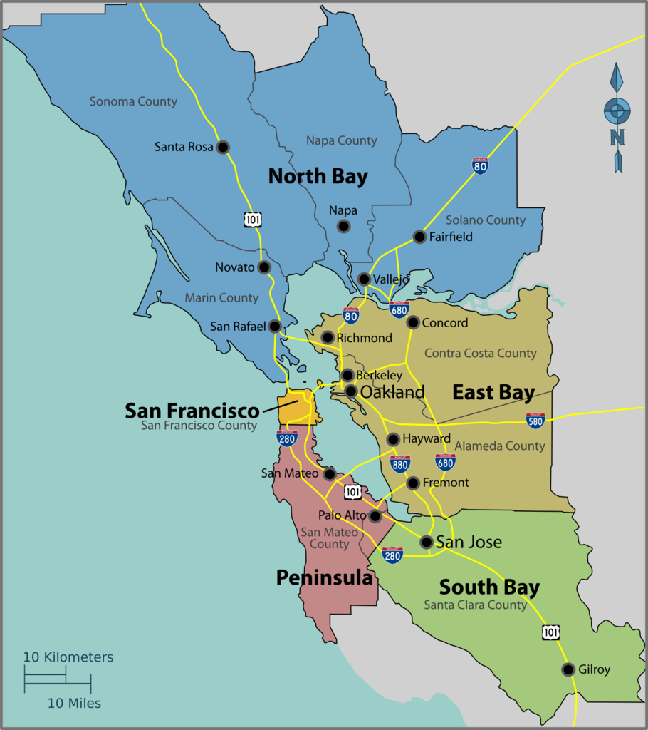
English: Map of the San Francisco Bay Area — the region in Northern California.
|
| दिनांक | |
| स्रोत | Image:Bayarea map.svg |
| लेखक | PerryPlanet |

|
File:Bayarea map.svg is a vector version of this file. It should be used in place of this PNG file when not inferior.
File:Bayarea map.png → File:Bayarea map.svg
For more information, see Help:SVG. |
 |
परवाना:
| This work has been released into the public domain by its author, User: (WT-shared) PerryPlanet at wts wikivoyage. This applies worldwide. असे करणे काही देशांमधे कायद्यानुसार शक्य नसू शकते. असे असल्यास : User: (WT-shared) PerryPlanet at wts wikivoyage grants anyone the right to use this work for any purpose, without any conditions, unless such conditions are required by law.
|
चढवल्याचे मुळ विवरण
| This file was imported from Wikivoyage WTS. |
The original description page was here. All following user names refer to wts.wikivoyage-old.
- 2010-10-17 03:39 (WT-shared) PerryPlanet[dead link] 1438×1616 (481629 bytes) {{Imagecredit|credit=PerryPlanet|captureDate=10/16/2010|location=Bay Area (California)|source=[[Image:Bayarea map.svg]]|caption=Bay Area Reg (Import from wikitravel.org/shared)
संचिकेचा इतिहास
संचिकेची त्यावेळची आवृत्ती बघण्यासाठी त्या दिनांक/वेळेवर टिचकी द्या.
| दिनांक/वेळ | छोटे चित्र | आकार | सदस्य | प्रतिक्रीया | |
|---|---|---|---|---|---|
| सद्य | १७:२१, २७ सप्टेंबर २०१७ | | १,५३९ × १,७३२ (४७५ कि.बा.) | Haha169 | okay finally fixed |
| १७:२०, २७ सप्टेंबर २०१७ |  | १,५३९ × १,७३४ (४७५ कि.बा.) | Haha169 | fix minor inconsistency | |
| १७:१८, २७ सप्टेंबर २०१७ |  | १,५३९ × १,७३२ (४७३ कि.बा.) | Haha169 | change font for readability, adjust hierarchy in favor of the subregions (that's what this map is being used for), and remove airports due to clutter | |
| १०:२१, २१ सप्टेंबर २०१७ |  | १,४६२ × १,६४५ (५०० कि.बा.) | Haha169 | ok was being lazy. fix sonoma county borders | |
| ०९:१०, २१ सप्टेंबर २०१७ |  | १,४५१ × १,६३४ (४९४ कि.बा.) | Haha169 | Add santa clara county lines and restore Sonoma County, can't find any literature on what part of Sonoma county is cut off from the Bay Area | |
| ०२:१९, १८ नोव्हेंबर २०१२ |  | १,४३८ × १,६१६ (४७० कि.बा.) | MGA73bot2 | {{BotMoveToCommons|wts.oldwikivoyage|year={{subst:CURRENTYEAR}}|month={{subst:CURRENTMONTHNAME}}|day={{subst:CURRENTDAY}}}} == {{int:filedesc}} == {{Information |description=Bay Area Regions Map. , Bay Area (California) * Map of: Bay Area (California)... |
दुवे
खालील पाने या संचिकेला जोडली आहेत:
जागतिक संचिका उपयोग
संचिकाचे इतर विकिपीडियावरील वापरः
- cy.wikipedia.org वरील उपयोग
- de.wikivoyage.org वरील उपयोग
- he.wikivoyage.org वरील उपयोग
- it.wikivoyage.org वरील उपयोग
- zh.wikipedia.org वरील उपयोग