
चित्र:Australian external territories.png
यापेक्षा मोठे चित्र उपलब्ध नाही.
Australian_external_territories.png (६४४ × ३७६ पिक्सेल, संचिकेचा आकार: १४ कि.बा., MIME प्रकार: image/png)

|
This locator map image could be re-created using vector graphics as an SVG file. This has several advantages; see Commons:Media for cleanup for more information. If an SVG form of this image is available, please upload it and afterwards replace this template with
{{vector version available|new image name}}.
It is recommended to name the SVG file “Australian external territories.svg”—then the template Vector version available (or Vva) does not need the new image name parameter. |
सारांश
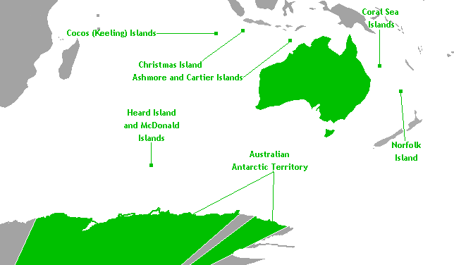
This is a map of Australia's external territories. The base map is Image:Antarctica territorial claims.png by User:Astrokey44 since it shows the AAT. The location of the other territories is Image:BlankMap-World-v6.png by the same user. The previous maps are under the GFDL; therefore, this map is too.
परवाना:
मी, या कामाचा/कामाची परवानाधारक, खालील परवान्यांअंतर्गत हे काम येथे प्रकाशित करत आहे :

|
फ्री सॉफ्टवेअर फाऊंडेशन द्वारे प्रकाशित जीएनयू मुक्त दस्ताऐवजीकरण परवाना, आवृत्ती १.२ किंवा त्यानंतरची,या अंतर्गत; या दस्तावेजास, नकलविण्याची, वितरणाची व/किंवा फेरबदलाची परवानगी दिल्या जाते या अटींसह कि त्यात कोणतेही निश्चलित(Invariant) विभाग नकोत,पृष्टपान मजकूर नको व मलपान मजकूर नको. GNU Free Documentation License हा मथळा असलेल्या विभागात,या परवान्याची प्रत अंतर्भूत केलेली आहे. |
| ही संचिका खालील परवान्याअंतर्गत आहे - क्रीएटिव्ह कॉमन्स Attribution-Share Alike 3.0 Unported. | ||
| ||
| GFDL चा भाग म्हणून परवाना अपडेट हि परवाना खूण या संचिकेस जोडलेली होती. (संचिका म्हणजे File) |
तुमच्या पसंतीचा परवाना तुम्ही निवडू शकता.
संचिकेचा इतिहास
संचिकेची त्यावेळची आवृत्ती बघण्यासाठी त्या दिनांक/वेळेवर टिचकी द्या.
| दिनांक/वेळ | छोटे चित्र | आकार | सदस्य | प्रतिक्रीया | |
|---|---|---|---|---|---|
| सद्य | १२:१०, १८ नोव्हेंबर २०१० | | ६४४ × ३७६ (१४ कि.बा.) | Hoshie | rm boundary lines in Africa, SE Asia, and PNG to focus on Australia and its territories; fixed color of the Comoros |
| १५:३०, १७ मार्च २००७ |  | ६४४ × ३७६ (१४ कि.बा.) | Hoshie | This is a map of Australia's external territories. The base map is Image:Antarctica territorial claims.png by User:Astrokey44 since it shows the AAT. The location of the other territories is Image:BlankMap-World-v6.png by the same user. The |
दुवे
खालील पाने या संचिकेला जोडली आहेत:
जागतिक संचिका उपयोग
संचिकाचे इतर विकिपीडियावरील वापरः
- af.wikipedia.org वरील उपयोग
- az.wikipedia.org वरील उपयोग
- ba.wikipedia.org वरील उपयोग
- be.wikipedia.org वरील उपयोग
- br.wikipedia.org वरील उपयोग
- bs.wikipedia.org वरील उपयोग
- cs.wikipedia.org वरील उपयोग
- de.wikipedia.org वरील उपयोग
- en.wikipedia.org वरील उपयोग
- eo.wikipedia.org वरील उपयोग
- gl.wikipedia.org वरील उपयोग
- hi.wikipedia.org वरील उपयोग
- hy.wikipedia.org वरील उपयोग
- incubator.wikimedia.org वरील उपयोग
- ka.wikipedia.org वरील उपयोग
- ko.wikipedia.org वरील उपयोग
- lv.wikipedia.org वरील उपयोग
- oc.wikipedia.org वरील उपयोग
- pa.wikipedia.org वरील उपयोग
- ru.wikipedia.org वरील उपयोग
- ru.wikinews.org वरील उपयोग
- sh.wikipedia.org वरील उपयोग
- simple.wikipedia.org वरील उपयोग
- sk.wikipedia.org वरील उपयोग
- sr.wikipedia.org वरील उपयोग
- ta.wikipedia.org वरील उपयोग
- th.wikipedia.org वरील उपयोग
- tr.wikipedia.org वरील उपयोग
- vec.wikipedia.org वरील उपयोग
- war.wikipedia.org वरील उपयोग
- xmf.wikipedia.org वरील उपयोग
- zh.wikipedia.org वरील उपयोग