
चित्र:Ankara districts.png
यापेक्षा मोठे चित्र उपलब्ध नाही.
Ankara_districts.png (७३३ × ६०० पिक्सेल, संचिकेचा आकार: १६६ कि.बा., MIME प्रकार: image/png)
सारांश
| वर्णन |
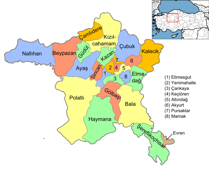
English: Map of the districts of Ankara province of Turkey. Created by Rarelibra 16:37, 1 December 2006 (UTC) for public domain use, using MapInfo Professional v8.5 and various mapping resources. Edited by One Homo Sapiens Corrected text where İ,Ş,ı,ğ,or ş occurs in name. Source: [statoids-com]. Increased font size and enhanced color differences among adjacent districts. |
| दिनांक | डिसेंबर १, इ.स. २००६ (original upload date) |
| स्रोत | No machine-readable source provided. Own work assumed (based on copyright claims). |
| लेखक | No machine-readable author provided. Rarelibra assumed (based on copyright claims). |
परवाना:
| I, the copyright holder of this work, release this work into the public domain. This applies worldwide. असे करणे काही देशांमधे कायद्यानुसार शक्य नसू शकते. असे असल्यास : मी कोणालाही कोणत्याही कारणासाठी हे काम वापरण्याचे अधिकार कोणत्याही बंधनाशिवाय जर अशी बंधने कायद्याने बंधनकारक नसतीलतर देत आहोत. |
संचिकेचा इतिहास
संचिकेची त्यावेळची आवृत्ती बघण्यासाठी त्या दिनांक/वेळेवर टिचकी द्या.
| दिनांक/वेळ | छोटे चित्र | आकार | सदस्य | प्रतिक्रीया | |
|---|---|---|---|---|---|
| सद्य | २०:३८, १५ सप्टेंबर २०१५ | | ७३३ × ६०० (१६६ कि.बा.) | AylakBiri | Yeni sınırlar. |
| ००:२९, २ जून २०१४ |  | १,०५६ × ८६४ (१९८ कि.बा.) | Joseph48 | - "Pursaklar" added. - Borders changed using File:Ankara location Pursaklar.svg | |
| २३:३०, २२ ऑक्टोबर २०११ |  | १,०५६ × ८१६ (४८ कि.बा.) | Karedefter | small things | |
| ०१:१०, २२ नोव्हेंबर २०१० |  | १,०५६ × ८१६ (४८ कि.बा.) | Joseph48 | Şultan Koçhisar > Şerefli Koçhisar | |
| ०२:०७, २९ डिसेंबर २००८ |  | १,०५६ × ८१६ (४१ कि.बा.) | One Homo Sapiens | Corrected text where İ,Ş,ı,ğ,or ş occurs in name. Source: [statoids-com]. Increased font size and enhanced color differences among adjacent districts. | |
| २२:०७, १ डिसेंबर २००६ |  | १,०५६ × ८१६ (४० कि.बा.) | Rarelibra | Map of the districts of Ankara province of Turkey. Created by ~~~~ for public domain use, using MapInfo Professional v8.5 and various mapping resources. |
दुवे
खालील पाने या संचिकेला जोडली आहेत:
जागतिक संचिका उपयोग
संचिकाचे इतर विकिपीडियावरील वापरः
- ar.wikipedia.org वरील उपयोग
- azb.wikipedia.org वरील उपयोग
- az.wikipedia.org वरील उपयोग
- ba.wikipedia.org वरील उपयोग
- br.wikipedia.org वरील उपयोग
- ca.wikipedia.org वरील उपयोग
- ceb.wikipedia.org वरील उपयोग
- ckb.wikipedia.org वरील उपयोग
- crh.wikipedia.org वरील उपयोग
- cs.wikipedia.org वरील उपयोग
- cy.wikipedia.org वरील उपयोग
- de.wikipedia.org वरील उपयोग
- Şereflikoçhisar
- Ankara (Provinz)
- Kızılcahamam
- Etimesgut
- Gölbaşı (Ankara)
- Haymana
- Evren (Ankara)
- Polatlı
- Sincan (Ankara)
- Vorlage:Navigationsleiste Landkreise der Provinz Ankara
- Çankaya
- Keçiören
- Mamak
- Kalecik
- Beypazarı
- Ayaş (Ankara)
- Yenimahalle
- Altındağ
- Balâ
- Elmadağ (Ankara)
- Nallıhan
- Pursaklar
- Çamlıdere (Ankara)
या संचिकेचे अधिक वैश्विक उपयोग पहा