
चित्र:Wallis and Futuna-CIA WFB Map.png
यापेक्षा मोठे चित्र उपलब्ध नाही.
Wallis_and_Futuna-CIA_WFB_Map.png (३३० × ३५४ पिक्सेल, संचिकेचा आकार: ३ कि.बा., MIME प्रकार: image/png)

|
This map image could be re-created using vector graphics as an SVG file. This has several advantages; see Commons:Media for cleanup for more information. If an SVG form of this image is available, please upload it and afterwards replace this template with
{{vector version available|new image name}}.
It is recommended to name the SVG file “Wallis and Futuna-CIA WFB Map.svg”—then the template Vector version available (or Vva) does not need the new image name parameter. |
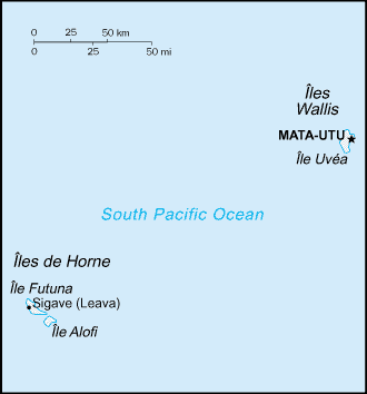
| वर्णन |
English: Map of Wallis and Futuna, showing islands and towns. |
|||
| दिनांक | ||||
| स्रोत | CIA, The World Factbook, 2004 (internet version) | |||
| लेखक | CIA | |||
| परवानगी (या संचिकेचा पुनर्वापर करीत आहे) |
|
|||
| इतर आवृत्तींस | Macedonian version |

संचिकेचा इतिहास
संचिकेची त्यावेळची आवृत्ती बघण्यासाठी त्या दिनांक/वेळेवर टिचकी द्या.
| दिनांक/वेळ | छोटे चित्र | आकार | सदस्य | प्रतिक्रीया | |
|---|---|---|---|---|---|
| सद्य | १४:४८, २७ मार्च २००५ | | ३३० × ३५४ (३ कि.बा.) | Wolfman~commonswiki | {{CIA-map}} |
दुवे
खालील पाने या संचिकेला जोडली आहेत:
जागतिक संचिका उपयोग
संचिकाचे इतर विकिपीडियावरील वापरः
- az.wikipedia.org वरील उपयोग
- be-tarask.wikipedia.org वरील उपयोग
- cs.wikipedia.org वरील उपयोग
- el.wikipedia.org वरील उपयोग
- en.wikipedia.org वरील उपयोग
- en.wikisource.org वरील उपयोग
- es.wikipedia.org वरील उपयोग
- eu.wikipedia.org वरील उपयोग
- fa.wikipedia.org वरील उपयोग
- fi.wikipedia.org वरील उपयोग
- gl.wikipedia.org वरील उपयोग
- hy.wikipedia.org वरील उपयोग
- id.wikipedia.org वरील उपयोग
- incubator.wikimedia.org वरील उपयोग
- it.wikipedia.org वरील उपयोग
- ja.wikipedia.org वरील उपयोग
- ka.wikipedia.org वरील उपयोग
- pl.wikipedia.org वरील उपयोग
- pt.wikipedia.org वरील उपयोग
- pt.wikivoyage.org वरील उपयोग
- to.wikipedia.org वरील उपयोग
- uk.wikipedia.org वरील उपयोग
- vi.wikipedia.org वरील उपयोग
- zh.wikipedia.org वरील उपयोग