
चित्र:Sierra Nevada map.png
यापेक्षा मोठे चित्र उपलब्ध नाही.
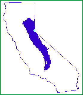
Sierra_Nevada_map.png (२७८ × ३१५ पिक्सेल, संचिकेचा आकार: ५ कि.बा., MIME प्रकार: image/png)

|
File:Sierra Nevada map vector.svg is a vector version of this file. It should be used in place of this PNG file when not inferior.
File:Sierra Nevada map.png → File:Sierra Nevada map vector.svg
For more information, see Help:SVG. |
 |
सारांश
| वर्णन | |
| दिनांक | |
| स्रोत | http://www.fs.fed.us/r5/spf/publications/fh_94-95/m261e.htm |
| लेखक | John W. Dale, U.S. Forest Service |
| परवानगी (या संचिकेचा पुनर्वापर करीत आहे) |
Public Domain |
परवाना:
This image is a work of the Forest Service of the United States Department of Agriculture. As a work of the U.S. federal government, the image is in the public domain.
|
संचिकेचा इतिहास
संचिकेची त्यावेळची आवृत्ती बघण्यासाठी त्या दिनांक/वेळेवर टिचकी द्या.
| दिनांक/वेळ | छोटे चित्र | आकार | सदस्य | प्रतिक्रीया | |
|---|---|---|---|---|---|
| सद्य | ०४:५१, ८ जानेवारी २००७ | | २७८ × ३१५ (५ कि.बा.) | Hike395 | {{Information |Description=Map of the Sierra Nevada, United States |Source=http://www.fs.fed.us/r5/spf/publications/fh_94-95/m261e.htm |Date=1999-07-12 |Author=John W. Dale, U.S. Forest Service |Permission=Public Domain }} |
दुवे
खालील पाने या संचिकेला जोडली आहेत:
जागतिक संचिका उपयोग
संचिकाचे इतर विकिपीडियावरील वापरः
- af.wikipedia.org वरील उपयोग
- cs.wikipedia.org वरील उपयोग
- cy.wikipedia.org वरील उपयोग
- de.wikipedia.org वरील उपयोग
- en.wikipedia.org वरील उपयोग
- eo.wikipedia.org वरील उपयोग
- fi.wiktionary.org वरील उपयोग
- frr.wikipedia.org वरील उपयोग
- fy.wikipedia.org वरील उपयोग
- gd.wikipedia.org वरील उपयोग
- gl.wikipedia.org वरील उपयोग
- he.wikipedia.org वरील उपयोग
- hr.wikipedia.org वरील उपयोग
- id.wikipedia.org वरील उपयोग
- ja.wikipedia.org वरील उपयोग
- ko.wikipedia.org वरील उपयोग
- ml.wikipedia.org वरील उपयोग
- nn.wikipedia.org वरील उपयोग
- no.wikipedia.org वरील उपयोग
- pnb.wikipedia.org वरील उपयोग
- pt.wikipedia.org वरील उपयोग
- sco.wikipedia.org वरील उपयोग
- sh.wikipedia.org वरील उपयोग
- simple.wikipedia.org वरील उपयोग
- sk.wikipedia.org वरील उपयोग
- sl.wikipedia.org वरील उपयोग
- sr.wikipedia.org वरील उपयोग
- sv.wikipedia.org वरील उपयोग
- ta.wikipedia.org वरील उपयोग
- tr.wikipedia.org वरील उपयोग
- uk.wikipedia.org वरील उपयोग
- vi.wikipedia.org वरील उपयोग
- zh.wikipedia.org वरील उपयोग