
चित्र:Nagaland locator map.svg

Size of this PNG preview of this SVG file: ७३४ × ६०० पिक्सेल. इतर resolutions: २९४ × २४० पिक्सेल | ५८७ × ४८० पिक्सेल | ९४० × ७६८ पिक्सेल | १,२५३ × १,०२४ पिक्सेल | २,५०६ × २,०४८ पिक्सेल | २,३९३ × १,९५६ पिक्सेल.
मूळ संचिका (SVG संचिका, साधारणपणे २,३९३ × १,९५६ pixels, संचिकेचा आकार: २७७ कि.बा.)
| शीर्षक |
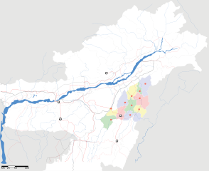
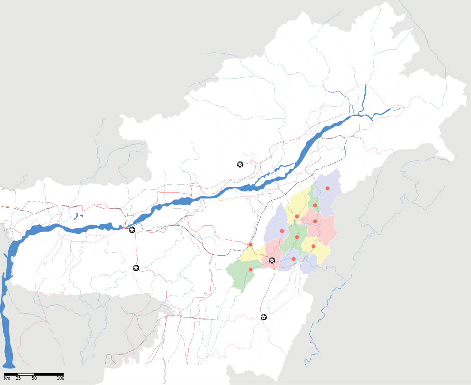
Nagaland locator Map |
| वर्णन |
Map of w:Nagaland with road and rail lines. Equirectangular projection. Geographic limits of the map: top=29.49, bottom=23.74, left=89.61, right=97.52. |
| दिनांक | |
| स्रोत |
स्वतःचे काम |
| रचनाकार | |
| परवानगी (या संचिकेचा पुनर्वापर करीत आहे) |
I, the copyright holder of this work, hereby publish it under the following license: ही संचिका खालील परवान्याअंतर्गत आहे - क्रीएटिव्ह कॉमन्स Attribution-Share Alike 3.0 Unported.
|
| Geotemporal data | |
| Date depicted | second half of 20 century आणि 21 century |
| Georeferencing | If inappropriate please set warp_status = skip to hide. |
| Archival data | |
| नोंदी | Part of WikiProject India Maps |
संचिकेचा इतिहास
संचिकेची त्यावेळची आवृत्ती बघण्यासाठी त्या दिनांक/वेळेवर टिचकी द्या.
| दिनांक/वेळ | छोटे चित्र | आकार | सदस्य | प्रतिक्रीया | |
|---|---|---|---|---|---|
| सद्य | १७:३५, १७ एप्रिल २००७ | | २,३९३ × १,९५६ (२७७ कि.बा.) | Planemad | not displaying, reupload |
| १७:३०, १७ एप्रिल २००७ |  | २,३९३ × १,९५६ (२७७ कि.बा.) | Planemad | not displaying, reupload | |
| १७:२५, १७ एप्रिल २००७ |  | २,३९३ × १,९५६ (२७७ कि.बा.) | Planemad | {{WikiProject_India_Maps |Title=Nagaland locator Map |Description=Map of w:Nagaland with road and rail lines |Source= [http://www.iitg.ernet.in/rcilts/assam_political.jpg IIT Guwahati - Assam Political map], [http://nagaland.nic.in/planning&coord/p |
दुवे
या चित्राशी जोडलेली पृष्ठे नाहीत.
जागतिक संचिका उपयोग
संचिकाचे इतर विकिपीडियावरील वापरः
- ar.wikipedia.org वरील उपयोग
- ast.wikipedia.org वरील उपयोग
- as.wikipedia.org वरील उपयोग
- ba.wikipedia.org वरील उपयोग
- bh.wikipedia.org वरील उपयोग
- bn.wikipedia.org वरील उपयोग
- ceb.wikipedia.org वरील उपयोग
- de.wikipedia.org वरील उपयोग
- en.wikipedia.org वरील उपयोग
- en.wikinews.org वरील उपयोग
- es.wikipedia.org वरील उपयोग
- fa.wikipedia.org वरील उपयोग
- hi.wikipedia.org वरील उपयोग
- ja.wikipedia.org वरील उपयोग
- kbd.wikipedia.org वरील उपयोग
- ml.wikipedia.org वरील उपयोग
- nl.wikipedia.org वरील उपयोग
- or.wikipedia.org वरील उपयोग
- pam.wikipedia.org वरील उपयोग
- pa.wikipedia.org वरील उपयोग
- pnb.wikipedia.org वरील उपयोग
- sa.wikipedia.org वरील उपयोग
- sw.wikipedia.org वरील उपयोग
- ta.wikipedia.org वरील उपयोग
- tr.wikipedia.org वरील उपयोग
- vi.wikipedia.org वरील उपयोग
- war.wikipedia.org वरील उपयोग
- www.wikidata.org वरील उपयोग
- yo.wikipedia.org वरील उपयोग
- zh.wikipedia.org वरील उपयोग