
चित्र:MessinaStrait.jpg
यापेक्षा मोठे चित्र उपलब्ध नाही.
MessinaStrait.jpg (६९४ × ६०० पिक्सेल, संचिकेचा आकार: १७४ कि.बा., MIME प्रकार: image/jpeg)
सारांश
| वर्णन |
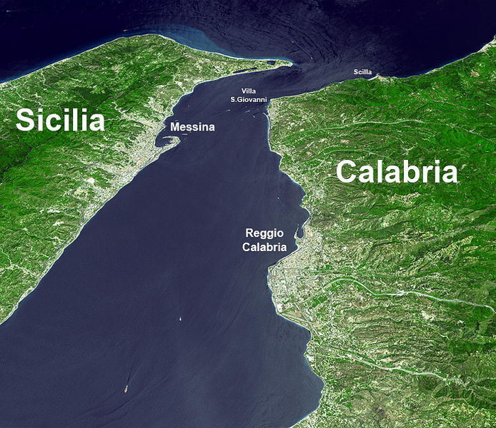
Deutsch: Straße von Messina.
English: Satellite photo of the Strait of Messina with names. NASA image. Satellite photo of the Strait of Messina.
עברית: מצר מסינה.
Hrvatski: Satelitska snimka Mesinskog tjesnaca.
Magyar: A Messinai-szoros űrfelvételen.
한국어: 메시나 해협 위성 사진.
Norsk nynorsk: Satellittbilete av Messinasundet med namn.
Polski: Cieśnina Mesyńska.
Română: Strâmtoarea Messina fotografiată din satelit.
Srpskohrvatski / српскохрватски: Satelitska snimka Mesinskog tjesnaca. |
| स्रोत | |
| लेखक |
परवाना:
| This file is in the public domain in the United States because it was solely created by NASA. NASA copyright policy states that "NASA material is not protected by copyright unless noted". (See Template:PD-USGov, NASA copyright policy page or JPL Image Use Policy.) | ||
 |
Warnings:
|
चढवल्याचे मुळ विवरण
The original description page was here. All following user names refer to en.wikipedia.
- 2006-05-01 18:28 Rhegion 700×605×8 (325599 bytes)
संचिकेचा इतिहास
संचिकेची त्यावेळची आवृत्ती बघण्यासाठी त्या दिनांक/वेळेवर टिचकी द्या.
| दिनांक/वेळ | छोटे चित्र | आकार | सदस्य | प्रतिक्रीया | |
|---|---|---|---|---|---|
| सद्य | ०५:३७, २७ एप्रिल २००७ | | ६९४ × ६०० (१७४ कि.बा.) | Matanya (usurped) | {{Information |Description=''no original description'' |Source=Originally from [http://en.wikipedia.org en.wikipedia]; description page is/was [http://en.wikipedia.org/w/index.php?title=Image%3AMessinaStrait.jpg here]. |Date=2006-05-01 (original upload da |
दुवे
खालील पाने या संचिकेला जोडली आहेत:
जागतिक संचिका उपयोग
संचिकाचे इतर विकिपीडियावरील वापरः
- az.wikipedia.org वरील उपयोग
- be-tarask.wikipedia.org वरील उपयोग
- be.wikipedia.org वरील उपयोग
- bg.wikipedia.org वरील उपयोग
- bs.wikipedia.org वरील उपयोग
- ce.wikipedia.org वरील उपयोग
- de.wikipedia.org वरील उपयोग
- el.wikipedia.org वरील उपयोग
- en.wikipedia.org वरील उपयोग
- eu.wikipedia.org वरील उपयोग
- fa.wikipedia.org वरील उपयोग
- fr.wikipedia.org वरील उपयोग
- fr.wikibooks.org वरील उपयोग
- fy.wikipedia.org वरील उपयोग
- he.wikipedia.org वरील उपयोग
- hu.wikipedia.org वरील उपयोग
- hyw.wikipedia.org वरील उपयोग
- id.wikipedia.org वरील उपयोग
- ja.wikipedia.org वरील उपयोग
- ja.wikibooks.org वरील उपयोग
- ka.wikipedia.org वरील उपयोग
- ko.wikipedia.org वरील उपयोग
- la.wikipedia.org वरील उपयोग
- nl.wikipedia.org वरील उपयोग
- nn.wikipedia.org वरील उपयोग
- pl.wikipedia.org वरील उपयोग
- ro.wikipedia.org वरील उपयोग
- sh.wikipedia.org वरील उपयोग
- tr.wikipedia.org वरील उपयोग
- vi.wikipedia.org वरील उपयोग